33rd Street station (IRT Lexington Avenue Line)
33rd Street is a local station on the IRT Lexington Avenue Line of the New York City Subway. Located at the intersection of Park Avenue and 33rd Street in the Murray Hill neighborhood of Manhattan, it is served by 6 trains at all times, <6> trains during weekdays in the peak direction, and 4 trains during late night hours.
33 Street | |||||||||||
|---|---|---|---|---|---|---|---|---|---|---|---|
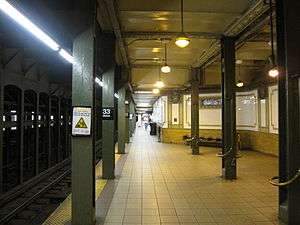 Downtown platform with Arts for Transit artwork on the columns | |||||||||||
| Station statistics | |||||||||||
| Address | East 33rd Street & Park Avenue New York, NY 10016 | ||||||||||
| Borough | Manhattan | ||||||||||
| Locale | Murray Hill, Kips Bay | ||||||||||
| Coordinates | 40°44′47″N 73°58′55″W | ||||||||||
| Division | A (IRT) | ||||||||||
| Line | IRT Lexington Avenue Line | ||||||||||
| Services | 4 6 | ||||||||||
| Transit connections | |||||||||||
| Structure | Underground | ||||||||||
| Platforms | 2 side platforms | ||||||||||
| Tracks | 4 | ||||||||||
| Other information | |||||||||||
| Opened | October 27, 1904[1] | ||||||||||
| Station code | 403[2] | ||||||||||
| Wireless service | |||||||||||
| Opposite-direction transfer available | No | ||||||||||
| Traffic | |||||||||||
| Passengers (2019) | 8,934,900[5] | ||||||||||
| Rank | 33 out of 424[5] | ||||||||||
| Station succession | |||||||||||
| Next north | Grand Central–42nd Street: 4 Grand Central (shuttle): no passenger service | ||||||||||
| Next south | 28th Street: 4 | ||||||||||
| |||||||||||
| |||||||||||
| |||||||||||
33rd Street Subway Station (IRT) | |||||||||||
New York City Landmark No. 1096 | |||||||||||
| MPS | New York City Subway System MPS | ||||||||||
| NRHP reference No. | 04001014[6] | ||||||||||
| NYCL No. | 1096 | ||||||||||
| Significant dates | |||||||||||
| Added to NRHP | September 17, 2004 | ||||||||||
| Designated NYCL | November 24, 1981[7] | ||||||||||


%26groups%3D_35398c6f7736b4bbbd4ab3c7d574e2cc6b213c75.svg)
History
Construction started on the first IRT line in 1900.[8]:162–191 The part of the line from City Hall to just south of 42nd Street was part of the original IRT line, opened on October 27, 1904 including a local station at 33rd Street.[1]
On April 13, 1948, the platform extensions to accommodate ten-car trains at this station along with those at 23rd Street, and 28th Street were opened for use.[9]
On December 27, 1948, a new entrance to the station at 32nd Street opened for use.[9]
Express stop proposals
It has been proposed several times–by the IRT and members of the public–that this station be rebuilt as an express stop to reduce overcrowding at the Grand Central–42nd Street station one stop to the north. It was estimated that the extra time spent by express trains at 33rd Street would be offset by the reduced dwell times at Grand Central.[10][11]
Station layout
| G | Street level | Entrances/exits |
| P Platform level |
Side platform | |
| Northbound local | ← ← | |
| Northbound express | ← | |
| Southbound express | | |
| Southbound local | | |
| Side platform | ||
There are four tracks and two side platforms, with the express tracks in the middle. The express tracks stay level, while the local tracks slowly incline from south to north to allow for the easier deceleration of local trains.[12] This results in a layout similar to Houston Street on the IRT Broadway-Seventh Avenue Line, the express tracks are at a lower elevation than the local tracks in the northern half of the station. North of the station, the two pairs of tracks in each direction separate into different tunnels because of the presence of the Murray Hill Tunnel, which runs under the center of this section of Park Avenue. The station was renovated in the late 1990s or early 2000s, and contains eagle plaques similar to those at Brooklyn Bridge–City Hall. The plaques contain the numerals "33". Fare control is at the platform level. The station has been on the National Register of Historic Places since 2004.[6]
| 33rd St to 34th St subway cross-section | |||||||||
| 11th Av | 10th & 9th Avs are skipped |
8th Av | Madison Square Garden |
7th Av | Storefronts | 6th Av & Broadway |
5th & Madison Avs are skipped |
Park Av | |
| mezzanine | A / C / E | concourse | 1 / 2 / 3 | Former Gimbel's passageway |
mezz | PATH | 6 / <6> | ||
| mezzanine | mezzanine | concourse | mezzanine | N / Q / R / W | |||||
| 7 / <7> | Penn Station | B/D/F/<F>/M | |||||||
Exits
| Exit location[13] | Number of exits | Platform served |
|---|---|---|
| NW corner of Park Avenue and 33rd Street | 1 | Southbound |
| SW corner of Park Avenue and 33rd Street | 1 | Southbound |
| NE corner of Park Avenue and 33rd Street | 1 | Northbound |
| SE corner of Park Avenue and 33rd Street | 1 | Northbound |
| SE corner of Park Avenue S and 32nd Street | 2 | Northbound |
| SW corner of Park Avenue S and 32nd Street | 2 | Southbound |
Image gallery
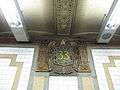 Faience plaque by Heins & LaFarge / Grueby Faience Company, 1904.
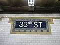 Tile name tablet by Heins & LaFarge / John H. Parry Co., 1904.

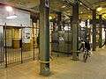 The unique fare control ironwork and Art for Transit installation on the columns
 Southbound street stairs
 33rd Street station in 1905
References
- "Our Subway Open: 150,000 Try It; Mayor McClellan Runs the First Official Train". The New York Times. October 28, 1904. p. 1. ISSN 0362-4331. Retrieved April 21, 2020.
- "Station Developers' Information". Metropolitan Transportation Authority. Retrieved June 13, 2017.
- "NYC Subway Wireless – Active Stations". Transit Wireless Wifi. Retrieved November 13, 2019.
- Attached PDF to "Governor Cuomo Announces Wireless Service and New "Transit Wireless WiFi" in Queens and Manhattan Subway Stations", governor.ny.gov
- "Facts and Figures: Annual Subway Ridership 2014–2019". Metropolitan Transportation Authority. 2020. Retrieved May 26, 2020.
- "NPS Focus". National Register of Historic Places. National Park Service. Retrieved November 6, 2011.
- "Interborough Rapid Transit System, Underground Interior" (PDF). New York City Landmarks Preservation Commission. November 24, 1981. Retrieved 2019-11-19.
- Walker, James Blaine (1918). Fifty Years of Rapid Transit — 1864 to 1917. New York, N.Y.: Law Printing. Retrieved November 6, 2016.
- Report for the three and one-half years ending June 30, 1949. New York City Board of Transportation. 1949. hdl:2027/mdp.39015023094926.
- Supreme Court Appellate Division-Second Department. pp. 458–460.
- ERA Headlights. Electric Railroaders Association. 1956.
- Lavis, Fred (1914). "The New York Rapid Transit Railway Extensions". nycsubway.org. Engineering News. Retrieved May 31, 2018.
- "MTA Neighborhood Maps: Union Square / Gramercy" (PDF). Metropolitan Transportation Authority. 2015. Retrieved August 6, 2015.
Further reading
- Lee Stokey. Subway Ceramics: A History and Iconography. 1994. ISBN 978-0-9635486-1-0
External links
| Wikimedia Commons has media related to 33rd Street (IRT Lexington Avenue Line). |
- nycsubway.org – IRT East Side Line: 33rd Street
- Station Reporter — 4 Train
- Station Reporter — 6 Train
- Forgotten NY — Original 28 - NYC's First 28 Subway Stations
- MTA's Arts For Transit — 33rd Street (IRT Lexington Avenue Line)
- 32nd Street entrance from Google Maps Street View
- 33rd Street entrance from Google Maps Street View
- downtown platform from Google Maps Street View
| Lexington Ave. Line |
|
|---|---|
| |
| Topics |  | |
|---|---|---|
| Lists by county |
| |
| Lists by city | ||
| Other lists | ||
| ||