Pelham Bay Park station
Pelham Bay Park is the northern terminal station of the IRT Pelham Line of the New York City Subway. Located across from Pelham Bay Park, at the intersection of the Bruckner Expressway and Westchester Avenue in the Pelham Bay neighborhood of the Bronx, it is served by the 6 train at all times, except weekdays in the peak direction, when the <6> serves it.
Pelham Bay Park | |||||||||
|---|---|---|---|---|---|---|---|---|---|
_by_David_Shankbone.jpg) Station platform | |||||||||
| Station statistics | |||||||||
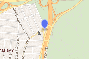
| Address | Bruckner Boulevard & Westchester Avenue Bronx, NY 10461 | ||||||||
| Borough | The Bronx | ||||||||
| Locale | Pelham Bay | ||||||||
| Coordinates | 40.852871°N 73.827138°W | ||||||||
| Division | A (IRT) | ||||||||
| Line | IRT Pelham Line | ||||||||
| Services | 6 | ||||||||
| Transit connections | |||||||||
| Structure | Elevated | ||||||||
| Platforms | 1 island platform (in service) 2 side platforms (unused) | ||||||||
| Tracks | 2 | ||||||||
| Other information | |||||||||
| Opened | December 20, 1920 | ||||||||
| Station code | 360[1] | ||||||||
| Accessible | |||||||||
| Opposite-direction transfer available | N/A | ||||||||
| Traffic | |||||||||
| Passengers (2019) | 2,134,403[2] | ||||||||
| Rank | 220 out of 424[2] | ||||||||
| Station succession | |||||||||
| Next north | (Terminal): 6 | ||||||||
| Next | none: 6 | ||||||||
| Next south | Buhre Avenue (local): 6 Parkchester (express): no regular service | ||||||||
| Next | Hunts Point Avenue: 6 | ||||||||
| |||||||||
| |||||||||
| |||||||||


History
Service to Pelham Bay Park began on December 20, 1920, when the Pelham Line was extended from Westchester Square.[3][4][5] Service to Pelham Bay Park was originally provided by a mix of through and shuttle trains during the 1920s.[6]:73–74
Renovations
As part of the 1968 Program for Action, the Pelham Line would have been extended to a modern terminal nearby in the Co-op City housing complex, and the Pelham Line would have been converted to B Division standards so lettered trains could use the line. As part of the plan, this station would no longer be the line's terminal.[7][8] Because of the 1975 New York City fiscal crisis, most of the remaining projects did not have funding, so they were declined.[9] If built, the extension would have been completed by the mid-1970s or early 1980s.[10][11]
In 1981, the Metropolitan Transportation Authority listed the station among the 69 most deteriorated stations in the subway system.[12]
The station's elevators were installed in December 1989, making the station one of the earliest to comply with the Americans with Disabilities Act of 1990. The elevators were renovated from June 2015 to April 2016.[13]
Station layout
| P Platform level |
Side platform, not in service | |
| West track | ← (No service: Parkchester) | |
| Island platform | ||
| East track | ← (No service: Parkchester) | |
| Side platform, not in service | ||
| M | Mezzanine | Fare control, station agent, MetroCard machines |
| G | Street level | Exit/entrance |
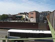
This is an elevated station which has two tracks, one island platform and two disused side platforms. The tracks end at bumper blocks at the north end of the platforms. The station was formerly set up as a Spanish solution with alighting passengers using the side platforms and boarding passengers using the island platform. Now all passengers use the island platform.[14]
During 2005, rooms were located on the side platforms for temporary crew use while the crew quarters at the north end of the station was rebuilt. At the south end is a staff-only crossover bridge between the center and west side platform. It also used to connect to the east side platform but that portion has been removed. There is also a tower and crew facilities at the south end. There are old style signs which are covered over on the main platform.
Pelham Bay Park is the only New York City Subway terminal that does not use numerical track labels, but rather track labels based on compass directions (i.e. East track, West track).[15] Punch boxes exist, however, at the south end of the island platform where the corresponding track numbers (Track 1 and 2) are used.
Exits
Fare control is in the mezzanine below the platforms. There are two staircases, an escalator, and an elevator that lead to Westchester Avenue. There is also a pedestrian bridge from the station entrance that crosses the Bruckner Expressway and leads to Pelham Bay Park.[16]
The Taking of Pelham One Two Three superstition
In the novel The Taking of Pelham One Two Three by Morton Freedgood and its film adaptations (the 1974 original and the 1998 and 2009 remakes), the train that gets hijacked leaves the Pelham Bay Park station at 1:23 pm. After the 1974 film's release, the New York City Transit Authority banned any schedule of a train leaving this station at 1:23am or 1:23pm. Eventually this policy was rescinded, but due to the superstitions involved dispatchers have continued to avoid scheduling a Manhattan-bound train to leave at 1:23.[17]
Nearby points of interest
In the early 1960s, the Pelham Bay Park station was the closest station to the defunct Freedomland U.S.A. amusement park, now the site of Co-op City.[19]
References
- "Station Developers' Information". Metropolitan Transportation Authority. Retrieved June 13, 2017.
- "Facts and Figures: Annual Subway Ridership 2014–2019". Metropolitan Transportation Authority. 2020. Retrieved May 26, 2020.
- York, Bronx Board of Trade, New (1931). A Comprehensive General and Industrial Survey: The Bronx in the City of New York. Bronx Board of Trade. p. 27.
- Brooklyn Daily Eagle Almanac. Brooklyn Daily Eagle. 1922. p. 372.
- Moodys Manual of Railroads and Corporation Securities. Moody Manual Company. 1922.
- Annual Report. J.B. Lyon Company. 1922.
- Metropolitan transportation, a program for action. Report to Nelson A. Rockefeller, Governor of New York. Metropolitan Commuter Transportation Authority. November 7, 1967. Retrieved October 1, 2015.
- Witkin, Richard (February 29, 1968). "$2.9-Billion Transit Plan For New York Area Links Subways, Rails, Airports; 2-Phase Proposal Program by Governor Calls for $1.6-Billion in First 10 Years 2-Phase Proposal For Transit Given" (PDF). The New York Times. Retrieved October 11, 2015.
- Raskin, Joseph B. (2013). The Routes Not Taken: A Trip Through New York City's Unbuilt Subway System. New York, New York: Fordham University Press. doi:10.5422/fordham/9780823253692.001.0001. ISBN 978-0-82325-369-2.
- "New Line May Get Double Trackage: Transit Unit Shift on Queens Super-Express" (PDF). The New York Times. February 21, 1971. Retrieved September 26, 2015.
- Burks, Edward C. (October 24, 1973). "Work Begun on Queens Subway Extension" (PDF). The New York Times. Retrieved September 26, 2015.
- Gargan, Edward A. (June 11, 1981). "Agency Lists Its 69 Most Deteriorated Subway Stations". The New York Times. Retrieved August 13, 2016.
- "Station Information". mta.info. Metropolitan Transportation Authority. Retrieved March 25, 2016.
- Dougherty, Peter (2006) [2002]. Tracks of the New York City Subway 2006 (3rd ed.). Dougherty. OCLC 49777633 – via Google Books.
- Tricarico, Michael (April 12, 2004). "Track labels with service sign and 6 train on East track". www.nycsubway.org. Pelham Bay Park: www.nycsubway.org. Retrieved July 27, 2016.
- "MTA Neighborhood Maps: Pelham Bay" (PDF). mta.info. Metropolitan Transportation Authority. 2015. Retrieved July 20, 2016.
- Dwyer, Jim (1991). Subway lives : 24 hours in the life of the New York City subway. New York: Crown. ISBN 0-517-58445-X.
- "MTA Neighborhood Maps: Pelham Bay / Westchester Square" (PDF). mta.info. Metropolitan Transportation Authority. 2018. Retrieved October 1, 2018.
- Fowle, Farnsworth (May 26, 1959). "Big Exhibit Park Planned In Bronx; 206-Acre Freedomland Will Have Mock Cities and Trips by Wagon and Steamer". The New York Times. ISSN 0362-4331. Retrieved January 6, 2020.
External links
| Wikimedia Commons has media related to Pelham Bay Park (IRT Pelham Line). |
- nycsubway.org – IRT Pelham Line: Pelham Bay Park
- Station Reporter — 6 Train
- The Subway Nut — Pelham Bay Park Pictures
- Burr Avenue entrance from Google Maps Street View
- Bruckner Boulevard entrance from Google Maps Street View
- Platforms from Google Maps Street View (Daytime)
- Platforms from Google Maps Street View (Night)
| Pelham Line |
|
|---|---|
| |