Rockport, Wood County, West Virginia
| Rockport, West Virginia | |
|---|---|
| Unincorporated community | |
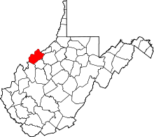
 Rockport, West Virginia Location within the state of West Virginia  Rockport, West Virginia Rockport, West Virginia (the US) | |
| Coordinates: 39°4′27″N 81°33′11″W / 39.07417°N 81.55306°WCoordinates: 39°4′27″N 81°33′11″W / 39.07417°N 81.55306°W | |
| Country | United States |
| State | West Virginia |
| County | Wood |
| Elevation | 705 ft (215 m) |
| Time zone | UTC-5 (Eastern (EST)) |
| • Summer (DST) | UTC-4 (EDT) |
| ZIP codes | 26169 |
| FIPS code | 54107[1] |
| GNIS feature ID | 1555508[2] |
Rockport is an unincorporated community in Wood County, West Virginia, United States. It lies at an elevation of 705 feet (215 m),[2] along Tygart Creek.[3] It is the last exit in Southern Wood County along I-77 and is unincorporated, with the ZIP code of 26169.[1]
References
- 1 2 Zip Code Lookup
- 1 2 U.S. Geological Survey Geographic Names Information System: Rockport, Wood County, West Virginia
- ↑ West Virginia Atlas & Gazetteer. Yarmouth, Me.: DeLorme. 1997. p. 33. ISBN 0-89933-246-3.
This article is issued from
Wikipedia.
The text is licensed under Creative Commons - Attribution - Sharealike.
Additional terms may apply for the media files.