Taïx
| Taïx | ||
|---|---|---|
| Commune | ||
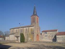 The church in Taïx | ||
| ||
 Taïx Location within Occitanie region  Taïx | ||
| Coordinates: 44°00′32″N 2°07′26″E / 44.0089°N 2.1239°ECoordinates: 44°00′32″N 2°07′26″E / 44.0089°N 2.1239°E | ||
| Country | France | |
| Region | Occitanie | |
| Department | Tarn | |
| Arrondissement | Albi | |
| Canton | Carmaux-2 Vallée du Cérou | |
| Intercommunality | Ségala-Carmausin | |
| Government | ||
| • Mayor (2008–2014) | Didier Somen | |
| Area1 | 4.76 km2 (1.84 sq mi) | |
| Population (2006)2 | 325 | |
| • Density | 68/km2 (180/sq mi) | |
| Time zone | UTC+1 (CET) | |
| • Summer (DST) | UTC+2 (CEST) | |
| INSEE/Postal code | 81291 /81130 | |
| Elevation |
275–347 m (902–1,138 ft) (avg. 301 m or 988 ft) | |
|
1 French Land Register data, which excludes lakes, ponds, glaciers > 1 km2 (0.386 sq mi or 247 acres) and river estuaries. 2 Population without double counting: residents of multiple communes (e.g., students and military personnel) only counted once. | ||
.svg.png)
Taïx is a commune in the Tarn department in southern France.
Geography
The river Vère rises in the south-eastern part of the commune, then flows westward through its southern part.
See also
References
| Wikimedia Commons has media related to Taïx. |
This article is issued from
Wikipedia.
The text is licensed under Creative Commons - Attribution - Sharealike.
Additional terms may apply for the media files.