Saint-Christophe, Tarn
| Saint-Christophe | |
|---|---|
| Commune | |
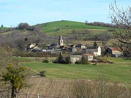 The church and surrounding buildings in Saint-Christophe | |
 Saint-Christophe Location within Occitanie region  Saint-Christophe | |
| Coordinates: 44°09′09″N 2°02′56″E / 44.1525°N 2.0489°ECoordinates: 44°09′09″N 2°02′56″E / 44.1525°N 2.0489°E | |
| Country | France |
| Region | Occitanie |
| Department | Tarn |
| Arrondissement | Albi |
| Canton | Carmaux-2 Vallée du Cérou |
| Intercommunality | Ségala-Carmausin |
| Government | |
| • Mayor (2008–2014) | Christian Gil |
| Area1 | 14.47 km2 (5.59 sq mi) |
| Population (2006)2 | 129 |
| • Density | 8.9/km2 (23/sq mi) |
| Time zone | UTC+1 (CET) |
| • Summer (DST) | UTC+2 (CEST) |
| INSEE/Postal code | 81245 /81190 |
| Elevation |
156–484 m (512–1,588 ft) (avg. 400 m or 1,300 ft) |
|
1 French Land Register data, which excludes lakes, ponds, glaciers > 1 km2 (0.386 sq mi or 247 acres) and river estuaries. 2 Population without double counting: residents of multiple communes (e.g., students and military personnel) only counted once. | |
Saint-Christophe is a commune in the Tarn department in southern France.
See also
References
| Wikimedia Commons has media related to Saint-Christophe (Tarn). |
This article is issued from
Wikipedia.
The text is licensed under Creative Commons - Attribution - Sharealike.
Additional terms may apply for the media files.