Saint-Paul-Cap-de-Joux
| Saint-Paul-Cap-de-Joux | ||
|---|---|---|
| Commune | ||
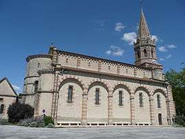 The church in Saint-Paul-Cap-de-Joux | ||
| ||
 Saint-Paul-Cap-de-Joux Location within Occitanie region  Saint-Paul-Cap-de-Joux | ||
| Coordinates: 43°38′53″N 1°58′35″E / 43.6481°N 1.9764°ECoordinates: 43°38′53″N 1°58′35″E / 43.6481°N 1.9764°E | ||
| Country | France | |
| Region | Occitanie | |
| Department | Tarn | |
| Arrondissement | Castres | |
| Canton | Plaine de l'Agoût | |
| Intercommunality | Pays d'Agout | |
| Government | ||
| • Mayor (2001–2008) | André Jouqueviel | |
| Area1 | 17.01 km2 (6.57 sq mi) | |
| Population (2006)2 | 1,030 | |
| • Density | 61/km2 (160/sq mi) | |
| Time zone | UTC+1 (CET) | |
| • Summer (DST) | UTC+2 (CEST) | |
| INSEE/Postal code | 81266 /81220 | |
| Elevation |
127–300 m (417–984 ft) (avg. 155 m or 509 ft) | |
|
1 French Land Register data, which excludes lakes, ponds, glaciers > 1 km2 (0.386 sq mi or 247 acres) and river estuaries. 2 Population without double counting: residents of multiple communes (e.g., students and military personnel) only counted once. | ||
.svg.png)
Saint-Paul-Cap-de-Joux is a commune in the Tarn department in southern France.
See also
References
| Wikimedia Commons has media related to Saint-Paul-Cap-de-Joux. |
This article is issued from
Wikipedia.
The text is licensed under Creative Commons - Attribution - Sharealike.
Additional terms may apply for the media files.