Lacroisille
| Lacroisille | ||
|---|---|---|
| Commune | ||
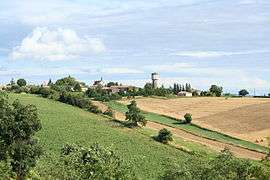 A general view of Lacroisille | ||
| ||
 Lacroisille Location within Occitanie region  Lacroisille | ||
| Coordinates: 43°35′04″N 1°55′52″E / 43.5844°N 1.9311°ECoordinates: 43°35′04″N 1°55′52″E / 43.5844°N 1.9311°E | ||
| Country | France | |
| Region | Occitanie | |
| Department | Tarn | |
| Arrondissement | Castres | |
| Canton | Lavaur Cocagne | |
| Intercommunality | Pays de Cocagne | |
| Government | ||
| • Mayor (2008–2014) | Yves Hurand | |
| Area1 | 6.67 km2 (2.58 sq mi) | |
| Population (2006)2 | 145 | |
| • Density | 22/km2 (56/sq mi) | |
| Time zone | UTC+1 (CET) | |
| • Summer (DST) | UTC+2 (CEST) | |
| INSEE/Postal code | 81127 /81470 | |
| Elevation |
213–315 m (699–1,033 ft) (avg. 320 m or 1,050 ft) | |
|
1 French Land Register data, which excludes lakes, ponds, glaciers > 1 km2 (0.386 sq mi or 247 acres) and river estuaries. 2 Population without double counting: residents of multiple communes (e.g., students and military personnel) only counted once. | ||
.svg.png)
Lacroisille is a commune in the Tarn department in southern France.
See also
References
| Wikimedia Commons has media related to Lacroisille. |
This article is issued from
Wikipedia.
The text is licensed under Creative Commons - Attribution - Sharealike.
Additional terms may apply for the media files.