Montgey
| Montgey | ||
|---|---|---|
| Commune | ||
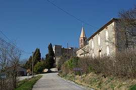 The road into Montgey | ||
| ||
 Montgey Location within Occitanie region  Montgey | ||
| Coordinates: 43°30′34″N 1°56′32″E / 43.5094°N 1.9422°ECoordinates: 43°30′34″N 1°56′32″E / 43.5094°N 1.9422°E | ||
| Country | France | |
| Region | Occitanie | |
| Department | Tarn | |
| Arrondissement | Castres | |
| Canton | Lavaur Cocagne | |
| Intercommunality | Lauragais-Revel-Sorezois | |
| Government | ||
| • Mayor (2008–2014) | Pierre Fraisse | |
| Area1 | 9.91 km2 (3.83 sq mi) | |
| Population (2006)2 | 258 | |
| • Density | 26/km2 (67/sq mi) | |
| Time zone | UTC+1 (CET) | |
| • Summer (DST) | UTC+2 (CEST) | |
| INSEE/Postal code | 81179 /81470 | |
| Elevation |
182–332 m (597–1,089 ft) (avg. 217 m or 712 ft) | |
|
1 French Land Register data, which excludes lakes, ponds, glaciers > 1 km2 (0.386 sq mi or 247 acres) and river estuaries. 2 Population without double counting: residents of multiple communes (e.g., students and military personnel) only counted once. | ||
.svg.png)
Montgey is a commune in the Tarn department in southern France.
See also
References
| Wikimedia Commons has media related to Montgey. |
This article is issued from
Wikipedia.
The text is licensed under Creative Commons - Attribution - Sharealike.
Additional terms may apply for the media files.