Arifat
| Arifat | |
|---|---|
| Commune | |
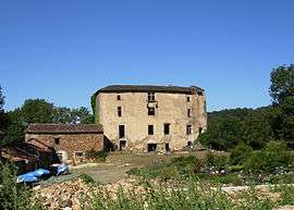 The chateau in Arifat | |
 Arifat Location within Occitanie region  Arifat | |
| Coordinates: 43°47′07″N 2°21′53″E / 43.7853°N 2.3647°ECoordinates: 43°47′07″N 2°21′53″E / 43.7853°N 2.3647°E | |
| Country | France |
| Region | Occitanie |
| Department | Tarn |
| Arrondissement | Castres |
| Canton | Le Haut Dadou |
| Intercommunality | CC Centre Tarn |
| Government | |
| • Mayor (2014-2020) | Sylvian Cals |
| Area1 | 20.28 km2 (7.83 sq mi) |
| Population (2015)2 | 159 |
| • Density | 7.8/km2 (20/sq mi) |
| Time zone | UTC+1 (CET) |
| • Summer (DST) | UTC+2 (CEST) |
| INSEE/Postal code | 81017 /81360 |
| Elevation |
267–583 m (876–1,913 ft) (avg. 430 m or 1,410 ft) |
|
1 French Land Register data, which excludes lakes, ponds, glaciers > 1 km2 (0.386 sq mi or 247 acres) and river estuaries. 2 Population without double counting: residents of multiple communes (e.g., students and military personnel) only counted once. | |
Arifat (Occitan: Arifat) is a commune of the Tarn department in southern France.
The inhabitants are known as Arifatois.
Geography
The commune is traversed by the river Dadou.
Demographics
| Year | 1962 | 1968 | 1975 | 1982 | 1990 | 1999 | 2006 | 2015 |
|---|---|---|---|---|---|---|---|---|
| Population | 182 | 215 | 195 | 201 | 171 | 158 | 159 | 159 |
Places of interest
- Château d'Arifat
- Cascade
See also
References
| Wikimedia Commons has media related to Arifat. |
This article is issued from
Wikipedia.
The text is licensed under Creative Commons - Attribution - Sharealike.
Additional terms may apply for the media files.