Paulinet
| Paulinet | ||
|---|---|---|
| Commune | ||
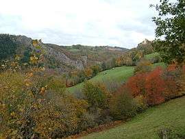 Gorge of Oulas and Castle Paulin | ||
| ||
 Paulinet Location within Occitanie region  Paulinet | ||
| Coordinates: 43°50′58″N 2°25′50″E / 43.8494°N 2.4306°ECoordinates: 43°50′58″N 2°25′50″E / 43.8494°N 2.4306°E | ||
| Country | France | |
| Region | Occitanie | |
| Department | Tarn | |
| Arrondissement | Albi | |
| Canton | Le Haut Dadou | |
| Intercommunality | Monts-d'Alban | |
| Government | ||
| • Mayor (2008–2014) | Damien Chamayou | |
| Area1 | 73.75 km2 (28.48 sq mi) | |
| Population (2006)2 | 572 | |
| • Density | 7.8/km2 (20/sq mi) | |
| Time zone | UTC+1 (CET) | |
| • Summer (DST) | UTC+2 (CEST) | |
| INSEE/Postal code | 81203 /81250 | |
| Elevation |
360–704 m (1,181–2,310 ft) (avg. 654 m or 2,146 ft) | |
|
1 French Land Register data, which excludes lakes, ponds, glaciers > 1 km2 (0.386 sq mi or 247 acres) and river estuaries. 2 Population without double counting: residents of multiple communes (e.g., students and military personnel) only counted once. | ||
.svg.png)
Paulinet is a commune in the Tarn department in southern France.
Geography
The commune is traversed by the river Dadou.
See also
References
| Wikimedia Commons has media related to Paulinet. |
This article is issued from
Wikipedia.
The text is licensed under Creative Commons - Attribution - Sharealike.
Additional terms may apply for the media files.