Lacaze
| Lacaze | ||
|---|---|---|
| Commune | ||
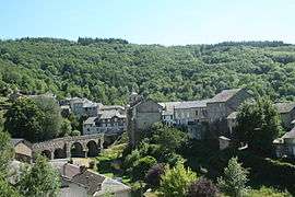 A general view of Lacaze | ||
| ||
 Lacaze Location within Occitanie region  Lacaze | ||
| Coordinates: 43°44′21″N 2°31′15″E / 43.7392°N 2.5208°ECoordinates: 43°44′21″N 2°31′15″E / 43.7392°N 2.5208°E | ||
| Country | France | |
| Region | Occitanie | |
| Department | Tarn | |
| Arrondissement | Castres | |
| Canton | Les Hautes Terres d'Oc | |
| Intercommunality | Val et Plateau Mont-de-Lacaune | |
| Government | ||
| • Mayor (2008–2014) | Michel Madern | |
| Area1 | 46.16 km2 (17.82 sq mi) | |
| Population (2008)2 | 315 | |
| • Density | 6.8/km2 (18/sq mi) | |
| Time zone | UTC+1 (CET) | |
| • Summer (DST) | UTC+2 (CEST) | |
| INSEE/Postal code | 81125 /81330 | |
| Elevation |
392–805 m (1,286–2,641 ft) (avg. 450 m or 1,480 ft) | |
|
1 French Land Register data, which excludes lakes, ponds, glaciers > 1 km2 (0.386 sq mi or 247 acres) and river estuaries. 2 Population without double counting: residents of multiple communes (e.g., students and military personnel) only counted once. | ||
.svg.png)
Lacaze (Occitan: La Casa, meaning the house) is a commune in the Tarn department in southern France.
Geography
The river Dadou forms part of the commune's northern border. The village lies on the banks of the Gijou, which flows westward through the commune, then forms most of its south-western border.
See also
References
| Wikimedia Commons has media related to Lacaze. |
This article is issued from
Wikipedia.
The text is licensed under Creative Commons - Attribution - Sharealike.
Additional terms may apply for the media files.