Monestiés
| Monestiés | ||
|---|---|---|
| Commune | ||
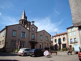 The town hall in Monestiés | ||
| ||
 Monestiés Location within Occitanie region  Monestiés | ||
| Coordinates: 44°04′19″N 2°05′52″E / 44.0719°N 2.0978°ECoordinates: 44°04′19″N 2°05′52″E / 44.0719°N 2.0978°E | ||
| Country | France | |
| Region | Occitanie | |
| Department | Tarn | |
| Arrondissement | Albi | |
| Canton | Carmaux-2 Vallée du Cérou | |
| Intercommunality | Ségala-Carmausin | |
| Government | ||
| • Mayor (2008–2014) | Denis Marty | |
| Area1 | 26.83 km2 (10.36 sq mi) | |
| Population (2006)2 | 1,340 | |
| • Density | 50/km2 (130/sq mi) | |
| Time zone | UTC+1 (CET) | |
| • Summer (DST) | UTC+2 (CEST) | |
| INSEE/Postal code | 81170 /81640 | |
| Elevation |
190–437 m (623–1,434 ft) (avg. 200 m or 660 ft) | |
|
1 French Land Register data, which excludes lakes, ponds, glaciers > 1 km2 (0.386 sq mi or 247 acres) and river estuaries. 2 Population without double counting: residents of multiple communes (e.g., students and military personnel) only counted once. | ||
.svg.png)
Monestiés (Occitan: Monestièr, meaning monastery) is a commune in the Tarn department in southern France.
It is a member of the Les Plus Beaux Villages de France ("The Most Beautiful Villages of France") association.
Geography
The commune is traversed by the Cérou river.
See also
References
| Wikimedia Commons has media related to Monestiés. |
This article is issued from
Wikipedia.
The text is licensed under Creative Commons - Attribution - Sharealike.
Additional terms may apply for the media files.