Arfons
| Arfons | ||
|---|---|---|
| Commune | ||
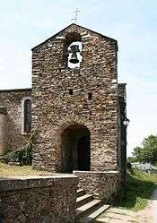 The church in Arfons | ||
| ||
 Arfons Location within Occitanie region  Arfons | ||
| Coordinates: 43°25′51″N 2°10′06″E / 43.4308°N 2.1683°ECoordinates: 43°25′51″N 2°10′06″E / 43.4308°N 2.1683°E | ||
| Country | France | |
| Region | Occitanie | |
| Department | Tarn | |
| Arrondissement | Castres | |
| Canton | La Montagne noire | |
| Intercommunality | Pays de Dourgne | |
| Government | ||
| • Mayor (2001–2008) | Alain Couzinié | |
| Area1 | 40.71 km2 (15.72 sq mi) | |
| Population (2006)2 | 191 | |
| • Density | 4.7/km2 (12/sq mi) | |
| Time zone | UTC+1 (CET) | |
| • Summer (DST) | UTC+2 (CEST) | |
| INSEE/Postal code | 81016 /81110 | |
| Elevation |
566–904 m (1,857–2,966 ft) (avg. 659 m or 2,162 ft) | |
|
1 French Land Register data, which excludes lakes, ponds, glaciers > 1 km2 (0.386 sq mi or 247 acres) and river estuaries. 2 Population without double counting: residents of multiple communes (e.g., students and military personnel) only counted once. | ||

Arfons (Arfons in Occitan) is a commune of the Tarn department in southern France.
See also
References
| Wikimedia Commons has media related to Arfons. |
This article is issued from
Wikipedia.
The text is licensed under Creative Commons - Attribution - Sharealike.
Additional terms may apply for the media files.