Vindrac-Alayrac
| Vindrac-Alayrac | |
|---|---|
| Commune | |
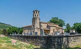 Saint-Martin Church of Vindrac-Alayrac | |
 Vindrac-Alayrac Location within Occitanie region  Vindrac-Alayrac | |
| Coordinates: 44°03′58″N 1°54′49″E / 44.0661°N 1.9136°ECoordinates: 44°03′58″N 1°54′49″E / 44.0661°N 1.9136°E | |
| Country | France |
| Region | Occitanie |
| Department | Tarn |
| Arrondissement | Albi |
| Canton | Carmaux-2 Vallée du Cérou |
| Intercommunality | Pays Cordais |
| Government | |
| • Mayor (2008–2014) | Régine Bessou |
| Area1 | 9.82 km2 (3.79 sq mi) |
| Population (2006)2 | 158 |
| • Density | 16/km2 (42/sq mi) |
| Time zone | UTC+1 (CET) |
| • Summer (DST) | UTC+2 (CEST) |
| INSEE/Postal code | 81320 /81170 |
| Elevation |
150–340 m (490–1,120 ft) (avg. 160 m or 520 ft) |
|
1 French Land Register data, which excludes lakes, ponds, glaciers > 1 km2 (0.386 sq mi or 247 acres) and river estuaries. 2 Population without double counting: residents of multiple communes (e.g., students and military personnel) only counted once. | |
Vindrac-Alayrac is a commune in the Tarn department in southern France.
Geography
The commune is traversed by the Cérou river.
See also
References
| Wikimedia Commons has media related to Vindrac-Alayrac. |
This article is issued from
Wikipedia.
The text is licensed under Creative Commons - Attribution - Sharealike.
Additional terms may apply for the media files.