Cambounet-sur-le-Sor
| Cambounet-sur-le-Sor | ||
|---|---|---|
| Commune | ||
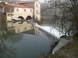 The Sor river in Cambounet-sur-le-Sor | ||
| ||
 Cambounet-sur-le-Sor Location within Occitanie region  Cambounet-sur-le-Sor | ||
| Coordinates: 43°34′41″N 2°06′49″E / 43.5781°N 2.1136°ECoordinates: 43°34′41″N 2°06′49″E / 43.5781°N 2.1136°E | ||
| Country | France | |
| Region | Occitanie | |
| Department | Tarn | |
| Arrondissement | Castres | |
| Canton | Le Pastel | |
| Intercommunality | Sor et Agout | |
| Government | ||
| • Mayor (2008–2014) | Sylvain Fernandez | |
| Area1 | 7.65 km2 (2.95 sq mi) | |
| Population (2006)2 | 795 | |
| • Density | 100/km2 (270/sq mi) | |
| Time zone | UTC+1 (CET) | |
| • Summer (DST) | UTC+2 (CEST) | |
| INSEE/Postal code | 81054 /81580 | |
| Elevation |
158–250 m (518–820 ft) (avg. 170 m or 560 ft) | |
|
1 French Land Register data, which excludes lakes, ponds, glaciers > 1 km2 (0.386 sq mi or 247 acres) and river estuaries. 2 Population without double counting: residents of multiple communes (e.g., students and military personnel) only counted once. | ||
.svg.png)
Cambounet-sur-le-Sor is a commune in the Tarn department in southern France.
See also
References
| Wikimedia Commons has media related to Cambounet-sur-le-Sor. |
This article is issued from
Wikipedia.
The text is licensed under Creative Commons - Attribution - Sharealike.
Additional terms may apply for the media files.