Cuq, Tarn
| Cuq | ||
|---|---|---|
| Commune | ||
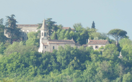 The church in Cuq | ||
| ||
 Cuq Location within Occitanie region  Cuq | ||
| Coordinates: 43°38′55″N 2°05′38″E / 43.6486°N 2.0939°ECoordinates: 43°38′55″N 2°05′38″E / 43.6486°N 2.0939°E | ||
| Country | France | |
| Region | Occitanie | |
| Department | Tarn | |
| Arrondissement | Castres | |
| Canton | Plaine de l'Agoût | |
| Intercommunality | Pays d'Agout | |
| Government | ||
| • Mayor (2008–2014) | Jean-Claude Prat | |
| Area1 | 14.99 km2 (5.79 sq mi) | |
| Population (2006)2 | 481 | |
| • Density | 32/km2 (83/sq mi) | |
| Time zone | UTC+1 (CET) | |
| • Summer (DST) | UTC+2 (CEST) | |
| INSEE/Postal code | 81075 /81570 | |
| Elevation |
152–322 m (499–1,056 ft) (avg. 200 m or 660 ft) | |
|
1 French Land Register data, which excludes lakes, ponds, glaciers > 1 km2 (0.386 sq mi or 247 acres) and river estuaries. 2 Population without double counting: residents of multiple communes (e.g., students and military personnel) only counted once. | ||
.svg.png)
Cuq (Occitan: Cuc, meaning dark) is a commune in the Tarn department in southern France.
See also
References
| Wikimedia Commons has media related to Cuq (Tarn). |
This article is issued from
Wikipedia.
The text is licensed under Creative Commons - Attribution - Sharealike.
Additional terms may apply for the media files.