Blaye-les-Mines
| Blaye-les-Mines | ||
|---|---|---|
| Commune | ||
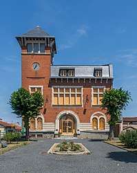 Former town hall of Blaye-les-Mines | ||
| ||
 Blaye-les-Mines Location within Occitanie region  Blaye-les-Mines | ||
| Coordinates: 44°01′54″N 2°07′57″E / 44.0317°N 2.1325°ECoordinates: 44°01′54″N 2°07′57″E / 44.0317°N 2.1325°E | ||
| Country | France | |
| Region | Occitanie | |
| Department | Tarn | |
| Arrondissement | Albi | |
| Canton | Carmaux-2 Vallée du Cérou | |
| Intercommunality | Carmausin | |
| Government | ||
| • Mayor (2014–20) | André Fabre | |
| Area1 | 8.88 km2 (3.43 sq mi) | |
| Population (2013)2 | 3,073 | |
| • Density | 350/km2 (900/sq mi) | |
| Time zone | UTC+1 (CET) | |
| • Summer (DST) | UTC+2 (CEST) | |
| INSEE/Postal code | 81033 /81400 | |
| Elevation |
241–344 m (791–1,129 ft) (avg. 339 m or 1,112 ft) | |
|
1 French Land Register data, which excludes lakes, ponds, glaciers > 1 km2 (0.386 sq mi or 247 acres) and river estuaries. 2 Population without double counting: residents of multiple communes (e.g., students and military personnel) only counted once. | ||
.svg.png)
Blaye-les-Mines is a commune in the Tarn department and Occitanie region of southern France.
The settlement grew up around the home of Gabriel de Solages (1711–1799), who founded the Compagnie minière de Carmaux and a glassworks at his château at Blaye.[1]
See also
References
- ↑ Monnié, A. (1929), "Le bassin houiller de Carmaux-Albi" (PDF), Annales de Géographie (in French), 38 (216): 581, doi:10.3406/geo.1929.9935, retrieved 2017-07-23
| Wikimedia Commons has media related to Blaye-les-Mines. |
This article is issued from
Wikipedia.
The text is licensed under Creative Commons - Attribution - Sharealike.
Additional terms may apply for the media files.