Salvagnac
| Salvagnac | ||
|---|---|---|
| Commune | ||
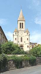 The church in Salvagnac | ||
| ||
 Salvagnac Location within Occitanie region  Salvagnac | ||
| Coordinates: 43°54′23″N 1°41′19″E / 43.9064°N 1.6886°ECoordinates: 43°54′23″N 1°41′19″E / 43.9064°N 1.6886°E | ||
| Country | France | |
| Region | Occitanie | |
| Department | Tarn | |
| Arrondissement | Albi | |
| Canton | Vignobles et Bastides | |
| Intercommunality | Pays Salvagnacois | |
| Government | ||
| • Mayor (2008–2014) | Barnard Miramond | |
| Area1 | 33.41 km2 (12.90 sq mi) | |
| Population (2010)2 | 1,078 | |
| • Density | 32/km2 (84/sq mi) | |
| Time zone | UTC+1 (CET) | |
| • Summer (DST) | UTC+2 (CEST) | |
| INSEE/Postal code | 81276 /81630 | |
| Elevation |
139–280 m (456–919 ft) (avg. 234 m or 768 ft) | |
|
1 French Land Register data, which excludes lakes, ponds, glaciers > 1 km2 (0.386 sq mi or 247 acres) and river estuaries. 2 Population without double counting: residents of multiple communes (e.g., students and military personnel) only counted once. | ||
.svg.png)
Salvagnac is a commune in the Tarn department in southern France.
See also
References
| Wikimedia Commons has media related to Salvagnac. |
This article is issued from
Wikipedia.
The text is licensed under Creative Commons - Attribution - Sharealike.
Additional terms may apply for the media files.