Fontrieu
| Fontrieu | |
|---|---|
| Commune | |
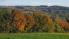 A panorama of the Fontrieu landscape | |
 Fontrieu Location within Occitanie region  Fontrieu | |
| Coordinates: 43°38′56″N 2°30′50″E / 43.649°N 2.514°ECoordinates: 43°38′56″N 2°30′50″E / 43.649°N 2.514°E | |
| Country | France |
| Region | Occitanie |
| Department | Tarn |
| Arrondissement | Castres |
| Canton | Les Hautes Terres d'Oc |
| Government | |
| • Mayor (2016–2020) | Didier Gavalda |
| Area1 | 102.62 km2 (39.62 sq mi) |
| Population (2013)2 | 933 |
| • Density | 9.1/km2 (24/sq mi) |
| Time zone | UTC+1 (CET) |
| • Summer (DST) | UTC+2 (CEST) |
| INSEE/Postal code | 81062 /81260 |
|
1 French Land Register data, which excludes lakes, ponds, glaciers > 1 km2 (0.386 sq mi or 247 acres) and river estuaries. 2 Population without double counting: residents of multiple communes (e.g., students and military personnel) only counted once. | |
Fontrieu is a commune in the Tarn department and Occitanie region of southern France. The municipality was established on 1 January 2016 by merger of the former communes of Castelnau-de-Brassac, Ferrières and Le Margnès.[1]
See also
References
| Wikimedia Commons has media related to Fontrieu. |
- ↑ Arrêté préfectoral 18 November 2015 (in French)
This article is issued from
Wikipedia.
The text is licensed under Creative Commons - Attribution - Sharealike.
Additional terms may apply for the media files.