Ambialet
| Ambialet | ||
|---|---|---|
| Commune | ||
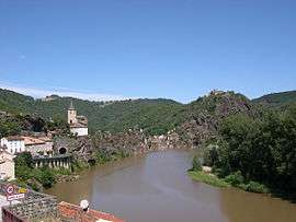 A general view of Ambialet | ||
| ||
 Ambialet Location within Occitanie region  Ambialet | ||
| Coordinates: 43°56′51″N 2°22′48″E / 43.9475°N 2.38°ECoordinates: 43°56′51″N 2°22′48″E / 43.9475°N 2.38°E | ||
| Country | France | |
| Region | Occitanie | |
| Department | Tarn | |
| Arrondissement | Albi | |
| Canton | Le Haut Dadou | |
| Intercommunality | Monts-d'Alban et Villefranchois | |
| Government | ||
| • Mayor (2014-2020) | Jean-Pierre Lefloch | |
| Area1 | 30.04 km2 (11.60 sq mi) | |
| Population (2014)2 | 459 | |
| • Density | 15/km2 (40/sq mi) | |
| Time zone | UTC+1 (CET) | |
| • Summer (DST) | UTC+2 (CEST) | |
| INSEE/Postal code | 81010 /81430 | |
| Elevation |
180–502 m (591–1,647 ft) (avg. 190 m or 620 ft) | |
|
1 French Land Register data, which excludes lakes, ponds, glaciers > 1 km2 (0.386 sq mi or 247 acres) and river estuaries. 2 Population without double counting: residents of multiple communes (e.g., students and military personnel) only counted once. | ||
.svg.png)
Ambialet is a commune of the Tarn department in southern France.
Ambialet's castle was a stronghold of the Cathars and was sacked during the Middle Ages by Simon de Montfort. It is also home to a study abroad campus of Saint Francis University, Loretto, Pennsylvania. Classes are held in the centuries-old former Franciscan Monastery in Ambialet, and during visits to Barcelona, Spain and Paris, France. All classes are taught in English.[1]
See also
References
- ↑ "Archived copy". Archived from the original on 2010-09-23. Retrieved 2010-05-12.
| Wikimedia Commons has media related to Ambialet. |
This article is issued from
Wikipedia.
The text is licensed under Creative Commons - Attribution - Sharealike.
Additional terms may apply for the media files.