Rihand Dam
| Rihand Dam | |
|---|---|
 Location of Rihand Dam in Uttar Pradesh  Rihand Dam (India) | |
| Official name | Govind Ballabh Pant Sagar |
| Country | India |
| Location | Sonbhadra, Uttar Pradesh |
| Coordinates | 24°12′9″N 83°0′29″E / 24.20250°N 83.00806°ECoordinates: 24°12′9″N 83°0′29″E / 24.20250°N 83.00806°E |
| Construction began | 1954 |
| Opening date | 1962 |
| Dam and spillways | |
| Height | 91 m (299 ft) |
| Length | 934 m (3,064 ft) |
| Reservoir | |
| Total capacity | 10.6 billion cubic metres |
| Active capacity | 8.9 billion cubic metres |
| Inactive capacity | 1.7 billion cubic metres |
| Catchment area | 5,148 km2 (1,988 sq mi) |
| Power Station | |
| Turbines | 6 x 50 MW Francis-type |
| Installed capacity | 300 MW[1] |
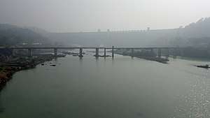
Rihand Dam (Hindi: रिहन्द बांध), also known as Govind Ballabh Pant Sagar, is the largest dam of India by volume. The reservoir of Rihand Dam is called Govind Ballabh Pant Sagar and is India's largest artificial lake.[2] Rihand Dam is a concrete gravity dam located at Pipri in Sonbhadra District in Uttar Pradesh, India.[3] Its reservoir area is on the border of Madhya Pradesh and Uttar Pradesh. It is located on the Rihand River, a tributary of the Son River. The catchment area of this dam extends over Uttar Pradesh, Madhya Pradesh & Chhattisgarh whereas it supplies irrigation water in Bihar located downstream of the river.
Specifications
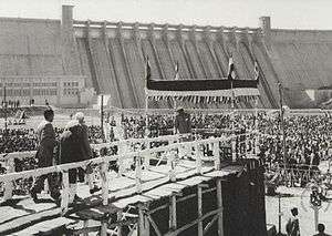
Govind Ballabh Pant Sagar is the largest man made lake in India by its gross storage capacity. Rihand dam is a concrete gravity dam with a length of 934.21 m. The maximum height of the dam is 91.44 m and was constructed during period 1954-62. The dam consists of 61 independent blocks and ground joints. The powerhouse is situated at the toe of the dam, with installed capacity of 300 MW (6 units of 50 MW each). The Intake Structure is situated between blocks no. 28 and 33. The Dam is in distress condition. It is proposed to carry out the rehabilitation works in the dam and the powerhouse.[4] The F.R.L. of the dam is 268.22 m and it impounds 8.6 Million Acre ft of water.The construction of the dam resulted in forced relocation of nearly 100,000 people [5]
Many super thermal power stations are located in the catchment area of the dam. These are Singrauli, Vindyachal, Rihand, Anpara & Sasan super thermal power stations and Renukoot thermal station. The high alkalinity run off water from the ash dumps (some are located in the reservoir area) of these coal-fired power stations ultimately collects in this reservoir enhancing its water alkalinity and pH range. Using high alkalinity water for irrigation converts the agriculture fields in to fallow Alkali soils.
See also
References
- ↑ "Rihand Power Station, Pipri, District : Sonebhadra (UP)". UPDESCO. Retrieved 10 July 2011.
- ↑ "Kathiawar-Gir dry deciduous forests". Terrestrial Ecoregions. World Wildlife Fund. Retrieved 2017-01-29.
- ↑ "Rihand Dam". Retrieved 5 December 2015.
- ↑ "Rehabilitation of Rihand dam". Retrieved 5 December 2015.
- ↑ B. Terminski, Development-Induced Displacement: Theoretical Frameworks and Current Challenges, Geneva, 2013