Snåsa
| Snåsa kommune Snåasen tjielte | |||
|---|---|---|---|
| Municipality | |||
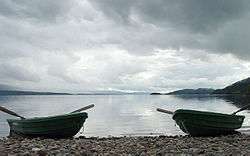
 View of Snåsa over Snåsavatnet | |||
| |||
 Snåsa within Trøndelag | |||
| Coordinates: 64°13′28″N 12°37′31″E / 64.22444°N 12.62528°ECoordinates: 64°13′28″N 12°37′31″E / 64.22444°N 12.62528°E | |||
| Country | Norway | ||
| County | Trøndelag | ||
| District | Innherad | ||
| Established | 1 Jan 1838 | ||
| Administrative centre | Snåsa | ||
| Government | |||
| • Mayor (2015) | Tone Våg (Ap) | ||
| Area | |||
| • Total | 2,342.66 km2 (904.51 sq mi) | ||
| • Land | 2,150.05 km2 (830.14 sq mi) | ||
| • Water | 192.61 km2 (74.37 sq mi) 8.2% | ||
| Area rank | #20 in Norway | ||
| Population (2017) | |||
| • Total | 2,159 | ||
| • Rank | #317 in Norway | ||
| • Density | 0.92/km2 (2.4/sq mi) | ||
| • Change (10 years) | -1.7% | ||
| Demonym(s) | Snåsning[1] | ||
| Time zone | UTC+01:00 (CET) | ||
| • Summer (DST) | UTC+02:00 (CEST) | ||
| ISO 3166 code | NO-5041 | ||
| Official language form | Neutral | ||
| Website |
snasa | ||


Snåsa (Norwegian) or Snåase (Southern Sami) is a municipality in Trøndelag county, Norway. It is part of the Innherred region. The administrative centre of the municipality is the village of Snåsa. Other villages include Agle and Jørstad.
Snåsa is one of the last strongholds for the seriously endangered Southern Sami language.
The 2,343-square-kilometre (905 sq mi) municipality is the 20th largest by area out of the 422 municipalities in Norway. Snåsa is the 317th most populous municipality in Norway with a population of 2,159. The municipality's population density is 1 inhabitant per square kilometre (2.6/sq mi) and its population has decreased by 1.7% over the last decade.[2]
General information
Snåsa was established as a municipality on 1 January 1838 (see formannskapsdistrikt). The eastern district of Lierne was separated from Snåsa on 1 January 1874 to form a separate municipality. Snåsa's boundaries have not changed since then.[3] On 1 January 2018, the municipality switched from the old Nord-Trøndelag county to the new Trøndelag county.
Name
The name of the municipality (and the old prestegjeld) comes from the Old Norse word Snǫs. The name is identical with the word snös which means "prominent mountain" or "overhanging rock" (possibly referring to the mountain of Bergsåsen, at the inner end of the lake Snåsavatnet). The name was spelled Snaasen until the early 20th century.[4] The Southern Sami language version of the name is Snåasen tjielte, which was officially accepted in 2010 as an alternate name for the Norwegian: Snåsa kommune.[5]
Coat of arms
The coat of arms is from modern times; they were granted on 17 March 1994. The arms show a yellow Lady Slipper orchid (Cypripedium calceolus) on a blue background. This particular flower is prevalent throughout the municipality, in fact at least 15 species of orchid have been found growing in Snåsa.[5][6]
Churches
The Church of Norway has one parish (sokn) within the municipality of Snåsa. It is part of the Nord-Innherad prosti (deanery) in the Diocese of Nidaros.
| Parish (Sokn) | Church Name | Location of the Church | Year Built |
|---|---|---|---|
| Snåsa | Snåsa Church | Snåsa | 1200 |
Geography
Snåsa is located about 180 kilometres (110 mi) northeast of the city of Trondheim, and it borders Sweden to the southeast. Snåsa borders the municipalities of Overhalla, Grong, and Lierne in the north and east, and Steinkjer and Verdal in the west and south. The 6th largest lake in the country, Snåsavatnet, is partly located in the municipality. Other lakes include Andorsjøen, Bangsjøene, Grøningen, Holderen, and Store Øyingen. The Blåfjella–Skjækerfjella National Park covers a lot of the eastern part of the municipality.
Government
All municipalities in Norway, including Snåsa, are responsible for primary education (through 10th grade), outpatient health services, senior citizen services, unemployment and other social services, zoning, economic development, and municipal roads. The municipality is governed by a municipal council of elected representatives, which in turn elect a mayor. The municipality falls under the Inntrøndelag District Court and the Frostating Court of Appeal.
Municipal council
The municipal council (Kommunestyre) of Snåsa is made up of 21 representatives that are elected to four year terms. Currently, the party breakdown is as follows:[7]
| Party Name | Name in Norwegian | Number of representatives | |
|---|---|---|---|
| Labour Party | Arbeiderpartiet | 10 | |
| Conservative Party | Høyre | 1 | |
| Centre Party | Senterpartiet | 7 | |
| Socialist Left Party | Sosialistisk Venstreparti | 2 | |
| Liberal Party | Venstre | 1 | |
| Total number of members: | 21 | ||
Transportation
The European route E6 highway runs through the municipality on the north side of the Snåsavatnet lake and the Nordland Line runs along the south side of the lake. The train stops at Jørstad Station and Snåsa Station.
Trivia
- Inge Altemberg (Elizabeth Reaser), the leading character in the movie Sweet Land comes to America from Snåsa.
Media gallery
 Sandmo, old husmannsplass, now protected
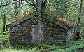 Protected building at Vinje old Vicarage
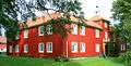 The main building, Vinje vicarage from the 18th century
 Stabbur hus storage shed
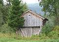 Bekkestue at Sandmo
References
- ↑ "Navn på steder og personer: Innbyggjarnamn" (in Norwegian). Språkrådet. Retrieved 2015-12-01.
- ↑ Statistisk sentralbyrå (2017). "Table: 06913: Population 1 January and population changes during the calendar year (M)" (in Norwegian). Retrieved 2017-10-01.
- ↑ Jukvam, Dag (1999). "Historisk oversikt over endringer i kommune- og fylkesinndelingen" (PDF) (in Norwegian). Statistisk sentralbyrå.
- ↑ Rygh, Oluf (1903). Norske gaardnavne: Nordre Trondhjems amt (dokpro.uio.no) (in Norwegian) (15 ed.). Kristiania, Norge: W. C. Fabritius & sønners bogtrikkeri. p. 273.
- 1 2 Store norske leksikon. "Snåsa" (in Norwegian). Retrieved 2011-08-05.
- ↑ "Civic heraldry of Norway - Norske Kommunevåpen". Heraldry of the World. Retrieved 2018-04-05.
- ↑ "Table: 04813: Members of the local councils, by party/electoral list at the Municipal Council election (M)" (in Norwegian). Statistics Norway. 2015.
External links
| Wikimedia Commons has media related to Snåsa. |

- Municipal fact sheet from Statistics Norway (in Norwegian)
| |||||||
| |||||||
| |||||||

| Authority control |
|---|