Siraha District
| Siraha District सिराहा जिल्ला | |
|---|---|
| District | |
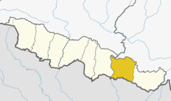 | |
| Country | Nepal |
| Province | Province No. 2 |
| Admin HQ. | Siraha |
| Government | |
| • Type | Coordination committee |
| • Body | DCC, Siraha |
| Area | |
| • Total | 1,188 km2 (459 sq mi) |
| Population (2011) | |
| • Total | 637,328 |
| • Density | 540/km2 (1,400/sq mi) |
| Time zone | UTC+5:45 (NPT) |
| Website | http://ddcsiraha.gov.np |
Siraha District (Nepali: सिराहा जिल्ला![]()
Geography and Climate
| Climate Zone[1] | Elevation Range | % of Area |
|---|---|---|
| Lower Tropical | below 300 meters (1,000 ft) | 90.5% |
| Upper Tropical | 300 to 1,000 meters 1,000 to 3,300 ft. |
9.5% |
Village Development Committees (VDCs) and Municipalities
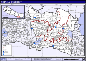
VDCs and Municipalities (blue) in Siraha District
- Arnama Lalpur
- Arnama Rampur
- Aurahi
- Ayodhyanagar
- Badharamal
- Barchhawa
- Bariyarpatti
- Basbita
- Bastipur
- Belaha
- Belhi
- Betauna
- Bhadaiya
- Bhagawanpur
- Bhagawatipur
- Bhawanipur
- Bhawanpur Kalabanzar
- Bhokraha
- Bishnupur Pra. Ma.
- Bishnupur Pra. Ra.
- Bishnupur Katti
- Brahmagaughadi
- Chandra Ayodhyapur
- Chandralalpur
- Chandraudyapur
- Chatari
- Chikana
- Devipur
- Dhangadi
- Dhangadhimai Municipality
- Dhodhana
- Dumari
- Durgapur
- Gadha
- Gauripur
- Gautari
- Golbazar Municipality
- Govindapur Malahanama
- Govindpur Taregana
- Hakpara
- Hanumannagar
- Harakathi
- Inarwa
- Itarhawa
- Itari Parsahi
- Itatar
- Jamadaha
- Janakinagar
- Jighaul
- Kabilasi
- Kachanari
- Kalyanpur Jabadi
- Kalyanpur Kalabanjar
- Karjanha
- Kharukyanhi
- Khirauna
- Krishnapur Birta
- Kushaha Laksiminiya
- Lagadi Gadiyani
- Lagadigoth
- Lahan Municipality
- Lalpur
- Laksminiya
- Laksmipur (Pra. Ma.)
- Laksmipur Patari
- Madar
- Mahadewa Portaha
- Mahanaur
- Maheshpur Gamharia
- Maheshpur Patari
- Majhauliya
- Majhaura
- Makhanaha
- Malhaniya Gamharia[2]
- Malhaniyakhori
- Mauwahi
- Mirchaiya Municipality
- Media
- Mohanpur Kamalpur
- Muksar
- Nahara Rigaul
- Naraha Balkawa
- Navarajpur
- Padariya Tharutol
- Phulkaha Kati
- Pipra Pra. Dha.
- Pipra Pra. Pi
- Pokharbhinda
- Rajpur
- Ramaul
- Rampur Birta
- Sakhuwanankar Katti
- Sanhaitha
- Sarshwar
- Sikron
- Silorba Pachhawari
- Siraha Municipality
- Sisawani
- Sitapur Pra. Da.
- Sitapur Pra. Ra.
- Sonmati Majhaura
- Sothayan
- Sukhachina
- Sukhipur Municipality
- Tenuwapati
- Thalaha Kataha
- Thegahi
- Tulsipur
- Vidhyanagar
See also
References
- ↑ The Map of Potential Vegetation of Nepal - a forestry/agroecological/biodiversity classification system (PDF), . Forest & Landscape Development and Environment Series 2-2005 and CFC-TIS Document Series No.110., 2005, ISBN 87-7903-210-9, retrieved Nov 22, 2013
- ↑ Raj mahisotha
- "Districts of Nepal". Statoids.
| Wikimedia Commons has media related to Siraha District. |
Places adjacent to Siraha District | ||||||||||
|---|---|---|---|---|---|---|---|---|---|---|
| ||||||||||
| Province No. 1 |  | |
|---|---|---|
| Province No. 2 | ||
| Province No. 3 | ||
| Gandaki Pradesh | ||
| Province No. 5 | ||
| Karnali Pradesh | ||
| Sudurpashchim Pradesh | ||
Coordinates: 26°39′0″N 86°12′0″E / 26.65000°N 86.20000°E
This article is issued from
Wikipedia.
The text is licensed under Creative Commons - Attribution - Sharealike.
Additional terms may apply for the media files.