Paudhur
| Paudhur पाऊॅदुर | |
|---|---|
| Village in Nepal | |
 Paudhur Location in Nepal | |
| Coordinates: 28°16′19″N 83°54′05″E / 28.27195°N 83.90138°ECoordinates: 28°16′19″N 83°54′05″E / 28.27195°N 83.90138°E | |
| Country |
|
| Zone | Gandaki Zone |
| District | Kaski District |
| Time zone | UTC+5:45 (Nepal Time) |
Paudhur (पाउँदुर)is a village in central Nepal 28 km west of the Pokhara valley. It is a part of ward no. 3 of Annapurna Gaupalika of Gandaki Pradesh of Nepal, and was the ward no.8 of the previous Dhikurpokhari VDC.It lies west of Nagdada way to Baglung. There are more than 100 houses in this village.
Geography
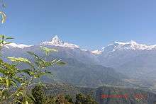
It is located in Annapurna Massif, north of Fewa Lake at a distance of 28 kilometers west of Pokhara after Sarangkot and Dhikurpokhari. It is on the mountainside ridge at an altitude of 1,678 meters, It equally provides panoramic Hilly views. On the northern side of Paudhur, Dhawalagiri can be seen in the far North-East. The Annapurna mountain range is clearly visible on the same side. To the east, the village overlooks the city of Pokhara across Fewa Lake.
Paudhur shares its territories with other villages of the then Dhikurpokhari VDC like Rayale, Kande, and Sera as well.
Sub villages
As Paudhur, a part of ward no. 3 of the Annapurna Gaupalika. There are sub villages or toles. Some of them are:
- Masthok
- Maidan
- Mulachare
- Dhungamuni
- Ranithok
Literacy
Paudhur is a literate village in Annapurna Gaupalika.About 85% of the people from each family are educated. There is one Primary School named Shree Laxmi Primary school. After completing high school students here go to Pokhara for higher education.