Muzaffarnagar
| Muzaffarnagar | |
|---|---|
| Metropolitan city | |
| Nickname(s): Sugar Bowl of India | |
 Muzaffarnagar | |
| Coordinates: 29°28′56″N 77°42′00″E / 29.482217°N 77.700116°ECoordinates: 29°28′56″N 77°42′00″E / 29.482217°N 77.700116°E | |
| Country | India |
| State | Uttar Pradesh |
| District | Muzaffarnagar(NCR) |
| First Settled | 1399 |
| Founded | 1633 |
| Incorporated as City | 1826 |
| Founded by | Saiyed Muzaffar Ali khan |
| Named for | Saiyed Muzaffar Ali khan |
| Government | |
| • Body | Municipal Board of Muzaffarnagar |
| • District Magistrate | Rajeev Sharma[1] |
| • Member of Parliament, Lok Sabha | Sanjeev Balyan (Bharatiya Janta Party) |
| • Member of Legislative Assembly | (Bharatiya Janta Party) |
| Area | |
| • Total | 150 km2 (60 sq mi) |
| Dimensions | |
| • Length | 12 km (7 mi) |
| • Width | 12 km (7 mi) |
| Elevation | 248 m (814 ft) |
| Population (2011)[2] | |
| • Rank | 15 (In U.P.) |
| • City | 392,768 |
| Demonym(s) | Muzaffarnagari |
| Languages | |
| • Official | Hindi,English and Urdu |
| • Literacy rate | 80.99 |
| Time zone | UTC+5:30 (IST) |
| PIN | 251001 |
| PIN | 251002 |
| Telephone code | 0131 |
| Vehicle registration | UP-12 |
| First newspaper | Dainik Dehat (est. 1936) |
| Website |
muzaffarnagar |
Muzaffarnagar (![]()
The city is located in the middle of highly fertile upper Ganga-Yamuna Doab region and is very near to the New Delhi and Saharanpur, making it one of the most developed and prosperous cities of Uttar Pradesh. This city is part of Delhi Mumbai Industrial Corridor (DMIC) and Amritsar Delhi Kolkata Industrial Corridor (ADKIC). It is the principal commercial, industrial and educational hub of Western Uttar Pradesh. Currently, Rajeev Sharma is the District Magistrate of Muzaffarnagar.[3]
History
The town was founded in 1633 near the site of an ancient town, Sarwat, by the son of a Mughal Commander Sayyid Muzaffar Khan during the reign of Shah Jahan.[4]
In 1901, during the British Raj, it was district in the Meerut Division in United Provinces of Agra and Oudh.[5]
2013 Muzaffarnagar riots
The 2013 Muzaffarnagar riots between Hindus and Muslims resulted in 62 deaths.[6]
According to a May 2015 report in India Today:
Shamli and adjoining Muzaffarnagar districts are considered sensitive ever since large-scale communal violence erupted in August and September 2013. More than 50 people had died and over 50,000 were rendered homeless ... The riot that ensued had engulfed many districts of western UP.[7]
Geography
MuzaffarNagar is located on an elevation of 272 meters above sea level[8] in the Doab region of Indo-Gangetic Plain. It is located 125 kilometres NE of the national capital, Delhi, and roughly 200 kilometres SE of Chandigarh, and near to such historical cities as Bijnor, Meerut and Hastinapur.
Climate
Muzaffarnagar has a monsoon influenced humid subtropical climate characterised by much hot summers and cooler winters. Summers last from early April to late June and are extremely hot. The monsoon arrives in late June and continues till the middle of September. Temperatures drop slightly, with plenty of cloud cover but with higher humidity. Temperatures rise again in October and the city then has a mild, dry winter season from late October to the middle of March. June is the warmest month of the year.
The temperature in June averages 30.2 °C. In January, the average temperature is 12.5 °C. It is the lowest average temperature of the whole year. The average annual temperature in Muzaffarnagar is 24.2 °C. The highest and lowest temperatures ever recorded in Muzaffarnagar are 45 °C (113 °F) on 29 may,1994 and −0.9 °C (30.4 °F) respectively. The rainfall here averages 929 mm. The driest month is November, with 8 mm of rain. Highest precipitation falls in July, with an average of 261.4 mm.
| Climate data for Muzaffarnagar (1971–2010) | |||||||||||||
|---|---|---|---|---|---|---|---|---|---|---|---|---|---|
| Month | Jan | Feb | Mar | Apr | May | Jun | Jul | Aug | Sep | Oct | Nov | Dec | Year |
| Average high °C (°F) | 19.2 (66.6) |
22.7 (72.9) |
27.9 (82.2) |
34.6 (94.3) |
37.4 (99.3) |
36.3 (97.3) |
33.2 (91.8) |
32.2 (90) |
32.2 (90) |
30.7 (87.3) |
26.3 (79.3) |
21.4 (70.5) |
29.5 (85.1) |
| Daily mean °C (°F) | 12.5 (54.5) |
15.6 (60.1) |
20.2 (68.4) |
26.1 (79) |
29.8 (85.6) |
30.2 (86.4) |
29.0 (84.2) |
28.4 (83.1) |
27.3 (81.1) |
23.3 (73.9) |
18.2 (64.8) |
13.9 (57) |
22.9 (73.2) |
| Average low °C (°F) | 5.8 (42.4) |
8.4 (47.1) |
12.4 (54.3) |
17.6 (63.7) |
22.2 (72) |
24.1 (75.4) |
24.9 (76.8) |
24.5 (76.1) |
22.3 (72.1) |
15.8 (60.4) |
10.0 (50) |
6.3 (43.3) |
16.2 (61.2) |
| Average precipitation mm (inches) | 25.1 (0.988) |
32.7 (1.287) |
23.5 (0.925) |
10.0 (0.394) |
25.6 (1.008) |
94.4 (3.717) |
261.4 (10.291) |
254.2 (10.008) |
162.2 (6.386) |
19.0 (0.748) |
8.0 (0.315) |
11.9 (0.469) |
929.0 (36.575) |
| Average rainy days | 1.9 | 2.5 | 2.2 | 1.2 | 2.1 | 4.4 | 9.5 | 9.9 | 5.5 | 1.1 | 0.5 | 1.1 | 42.0 |
| Source: [9] | |||||||||||||
Demographics
As of the 2011 census, Muzaffar Nagar municipality had a population of 392,451[2] and the urban agglomeration had a population of 494,792.[10] The municipality had a sex ratio of 897 females per 1,000 males and 12.2% of the population were under six years old.[2] Effective literacy was 80.99%; male literacy was 85.82% and female literacy was 75.65%.[2]
The city has 55.79% Hindus, 41.39% Muslims, 1.5% Sikhs, 0.5% Christians and 2% Jains.[11]
Muzaffarnagar city is governed by Municipal Council which comes under the remit of the Muzaffarnagar Urban Agglomeration. The city's population is 392,451; the urban/metropolitan population is 494,792, of which 261,338 are males and 233,454 are females. The majority of the population speaks Hindi.
Language
Khari Boli, a prestigious dialect of Hindi, is the native tongue of the city which resembles a lot with the Haryanvi dialect of Hindi.
Economy
Sugar and jaggery production are important industries in the district. As a result of the farming activities around, the city is an important hub of jaggery trading business.[12]
Muzaffarnagar is an important industrial city with sugar, steel and paper being the major industries. District Muzaffarnagar has 8 sugar mills. Many steel companies market their steel products, including angles and bars, through media in the country. More than 40% of the region's population is engaged in agriculture. According to Economic Research firm Indicus Analytics, Muzaffarnagar has the highest agricultural GDP in Uttar Pradesh, as well as UP's largest granary. Despite its economic strength, the city has been absent from the map of the foreign and modern business establishments. The city presents challenges, particularly in regard to crime and a decaying infrastructure.
CWC Godowns, Bamanheri
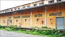
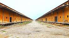
Central Warehousing Corporation (CWC) has its base depot in Bamanheri village on the outskirts of Muzaffarnagar city. With a capacity of 1.5 lakh metric tonnes (150000 MT) this is counted among largest of CWC depots.
Bright way, Muzaffarnagar Bright way an Import-Export Company have its Headquarters in the City Established November, 2015. The Company is well Known for Export of Basmati Rice and Ready made Garments to many famous Gulf Countries such as Saudi arabia, Oman, Qatar and many EU countries. THe Company is Registered Under Director General of foreign Trade, Government of India.
This depot is currently operated by Food Corporation of India (FCI) and stores around 80000 MT of food grains (Wheat & Rice) to ensure food security in the region. FCI is the nodal agency which procures food grains from farmers and stock them in this depot.
Transportation
Muzaffarnagar is well connected by road and railway networks. The Ghaziabad - Saharanpur line passes through the city thus forming the backbone of the long-distance and best possible travel from the city. Indian Railways provides connections to New Delhi, Western Uttar Pradesh, Jammu & Kashmir, Punjab, South India, and other parts of the country. Dehradun Shatabdi Express and Dehradun Jan Shatabdi Express trains pass through and halt at the Muzaffarnagar station. The Meerut - Shaharanpur section of this railway route is now being developed as a part of the Eastern Dedicated Freight Corridor. The corridor extends from Ludhiana in Punjab to Dankuni in West Bengal.
.png)
The National Highway - 58 (NH-58) passes through Muzaffarnagar city. This highway provides connections towards Delhi on the southern direction and upper reaches of the Himalayas in the Uttarakhand state on the northern direction. The highway is the backbone of the road transportation for the Muzaffarnagar city as well as Garhwal region of Uttarakhand. Cities and areas of Hardwar, Rishikesh, Dehradun as well as Badrinath and Kedarnath are served by this highway.
Environmental concerns
Muzaffarnagar lies approximately halfway on the road from Delhi to Rishikesh (the NH-58). As a result many roadside resorts and eateries have sprung up on the highway near the city. Especially, the town of Khatauli is famed for its canal side forest park named "Cheetal". Once visited for the sight of deer and rabbits and other wild animals, the Cheetal is now encroached by privately owned dhabas and resorts thus sidelining the animals.
City transportation mostly consists of tricycles and 3-wheeled vehicles, rickshaws. An international airport, Muzaffarnagar International Airport, was proposed in the city in order to reduce the traffic in at the Indira Gandhi International Airport, however, the same was transferred to the Jewar Airport.
Notable People of Muzaffarnagar
- Narain Singh (politician), Gurjar leader and deputy chief minister of UP
- Swami Kalyandev (1876–2004), was an ascetic who worked in the field of education and social reforms throughout his life. He was awarded the Padma Bhushan by the Indian government
- Liaquat Ali Khan, first Prime Minister of Pakistan (once lived in Muzaffarnagar)
- Nawazuddin Siddiqui, Bollywood actor
- Neeraj Agnihotri, cinematographer, photographer and author
- Harendra Singh Malik, political figure
- Kartar Singh Bhadana, political figure[13]
- Sultan Rahi, Pakistani actor
- Brahma Singh, scientist and agriculturist; awarded the Padma Shri by the Indian government.
Religious establishments in Muzaffarnagar
- Baghra, a holy shrine of Hazrat Abbas.
- Shiv Murti at Shiv Chowk, Bhagat Singh Rd, Sutharshahi
- Brahma Ji Temple is situated in the town of Budhana on the banks of the Hindon River.
- Kali-Nadi Devi Mandir, one of the city's oldest temples, is situated at the west end of the city, and holds a great mythological importance. On the day following the festival of Holi, a large fair is held in and around the temple.
- Vahelna, 4 km from the city, is a holy site for Jains.
- Bhairo-ka-Mandir is a temple dedicated to Bhairo in the heart of the city on Ansari Road.
- Shri Shri Golokdham is a religious place for devotees of Krishna, situated at heart of Muzaffarnagar city.
- Sankirtan Bhawan, popularly known as Kirtan Bhawan, is situated in the neighbourhood of New Mandi; it provides food for the needy.
- Dallu Devta is a religious site near Kali Nadi.
- Balaji Dham temple, also known as Balaji Temple, it is situated in the New Mandi neighbourhood of Muzaffarnagar.
References
- ↑ "Who's Who". muzaffarnagar.nic.in. Retrieved 18 May 2018.
- 1 2 3 4 "Provisional Population Totals, Census of India 2011; Cities having population 1 lakh and above" (pdf). Office of the Registrar General & Census Commissioner, India. Retrieved 27 March 2012.
- ↑ "District magistrate Muzaffarnagar Rajeev Sharma has confirmed that 11 children have died in relief camp here and said the administration is looking into reports of death of six more children". The Times of India. Retrieved 1 February 2018.
- ↑ "Muzaffarnagar City". Imperial Gazetteer of India, Digital South Asia Library, Volume 18. 1909. p. 93. Retrieved 9 September 2013.
- ↑ Muzaffarnagar District The Imperial Gazetteer of India, 1909, v. 18, p. 83.
- ↑ "Government releases data of riot victims identifying religion". The Times of India. 24 September 2013. Retrieved 11 July 2014.
- ↑ "Western Uttar Pradesh tense after communal violence in Shamli". India Today. 4 May 2015. Retrieved 25 September 2016.
- ↑ "Maps, Weather, and Airports for Muzaffarnagar, India". www.fallingrain.com. Retrieved 1 February 2018.
- ↑ Climatological table per Indian Meteorological department, city.imd.gov.in; accessed 26 January 2018.
- ↑
- 1 2 "Population by religion community - 2011". Census of India, 2011. The Registrar General & Census Commissioner, India. Archived from the original on 25 August 2015.
- ↑ "Muzaffarnagar clashes sour its famed jaggery business". indiatimes.com. India Times. 19 September 2013. Retrieved 10 July 2014.
- ↑ "Elections: Uttar Pradesh Assembly". Retrieved 18 May 2018.