Elvalandet
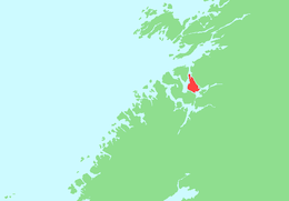 | |
 Elvalandet Location of the island  Elvalandet Elvalandet (Norway) | |
| Geography | |
|---|---|
| Location | Trøndelag, Norway |
| Coordinates | 64°34′53″N 11°23′35″E / 64.5814°N 11.3930°ECoordinates: 64°34′53″N 11°23′35″E / 64.5814°N 11.3930°E |
| Area | 38.184 km2 (14.743 sq mi) |
| Area rank |
|
| Length | 12 km (7.5 mi) |
| Width | 7 km (4.3 mi) |
| Highest elevation | 317 m (1,040 ft) |
| Highest point | Strandfjellet |
| Administration | |
|
Norway | |
| County | Trøndelag |
| Municipalities | Namsos and Fosnes |
Elvalandet is an island in Trøndelag county, Norway. The 38.184-square-kilometre (14.743 sq mi) island is located in the municipalities of Namsos and Fosnes. It is located in the Lauvøyfjorden, just south of the island of Jøa, east of the island of Otterøya, and west of the mainland. The town of Namsos lies about 10 kilometres (6.2 mi) south of the island.[1]
The island is connected to the mainland by a bridge on the Norwegian County Road 769. There is a ferry connection on the north side of the island to the nearby island of Jøa. Most of the island is forested. The island is the 82nd largest island in Norway.[2]
See also
References
- ↑ Thorsnæs, Geir, ed. (2017-06-17). "Elvalandet". Store norske leksikon (in Norwegian). Kunnskapsforlaget. Retrieved 2018-04-28.
- ↑ "100 største øyene i Norge" (in Norwegian). Kartverket. 2016-05-06. Retrieved 2018-04-28.
This article is issued from
Wikipedia.
The text is licensed under Creative Commons - Attribution - Sharealike.
Additional terms may apply for the media files.