Austra
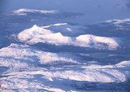 Aerial view from the east towards west, of Bindal municipality in Nordland county, Norway. | |
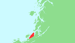 | |
 Austra Location of the island  Austra Austra (Norway) | |
| Geography | |
|---|---|
| Location | Trøndelag and Nordland, Norway |
| Coordinates | 65°05′01″N 11°52′37″E / 65.0837°N 11.8769°ECoordinates: 65°05′01″N 11°52′37″E / 65.0837°N 11.8769°E |
| Area | 88 km2 (34 sq mi) |
| Length | 21 km (13 mi) |
| Width | 6.5 km (4.04 mi) |
| Coastline | 61 km (37.9 mi) |
| Highest elevation | 588 m (1,929 ft) |
| Highest point | Romsskåla |
| Administration | |
|
Norway | |
| Counties | Trøndelag and Nordland |
| Municipality | Nærøy, Leka, Bindal |
Austra is an island on the border between Trøndelag and Nordland counties in Norway. The 88-square-kilometre (34 sq mi) island is shared between the municipalities of Bindal, Leka, and Nærøy. The highest point is the 588-metre-tall (1,929 ft) Romsskåla. The village of Årset lies on the southeastern shore, along the Årsetfjorden.[1]
See also
References
- ↑ Thorsnæs, Geir, ed. (2017-11-13). "Austra". Store norske leksikon (in Norwegian). Kunnskapsforlaget. Retrieved 2018-04-30.
This article is issued from
Wikipedia.
The text is licensed under Creative Commons - Attribution - Sharealike.
Additional terms may apply for the media files.