Enclave and exclave
An enclave is a territory, or a part of a territory, that is entirely surrounded by the territory of one other state.[1] Territorial waters have the same sovereign attributes as land, and enclaves may therefore exist within territorial waters.[2]:60
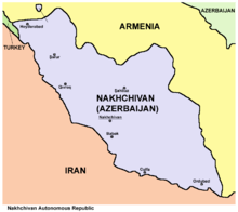
An exclave is a portion of a state or territory geographically separated from the main part by surrounding alien territory (of one or more states).[3] Many exclaves are also enclaves. Enclave is sometimes used improperly to denote a territory that is only partly surrounded by another state.[1] Vatican City and San Marino, enclaved by Italy, and Lesotho, enclaved by South Africa, are the only completely enclaved states. Unlike an enclave, an exclave can be surrounded by several states.[4] The Azerbaijani exclave of Nakhchivan is an example of an exclave.
Semi-enclaves and semi-exclaves are areas that, except for possessing an unsurrounded sea border (a coastline contiguous with international waters), would otherwise be enclaves or exclaves.[4]:116[5]:12–14 Enclaves and semi-enclaves can exist as independent states (Monaco, Gambia and Brunei are semi-enclaves), while exclaves always constitute just a part of a sovereign state (like the Kaliningrad Oblast).[4]
A pene-enclave is a part of the territory of one country that can be conveniently approached—in particular, by wheeled traffic—only through the territory of another country.[6]:283 Pene-enclaves are also called functional enclaves or practical enclaves.[5]:31 Many pene-exclaves partially border their own territorial waters (i.e., they are not surrounded by other nations' territorial waters), such as Point Roberts, Washington. A pene-enclave can also exist entirely on land, such as when intervening mountains render a territory inaccessible from other parts of a country except through alien territory. A commonly cited example is the Kleinwalsertal, a valley part of Vorarlberg, Austria, that is only accessible from Germany to the north.
Origin and usage
The word enclave is French and first appeared in the mid-15th century as a derivative of the verb enclaver (1283), from the colloquial Latin inclavare (to close with a key).[7] Originally, it was a term of property law that denoted the situation of a land or parcel of land surrounded by land owned by a different owner, and that could not be reached for its exploitation in a practical and sufficient manner without crossing the surrounding land.[7] In law, this created a servitude[8] of passage for the benefit of the owner of the surrounded land. The first diplomatic document to contain the word enclave was the Treaty of Madrid, signed in 1526.[2]:61
Later, the term enclave began to be used also to refer to parcels of countries, counties, fiefs, communes, towns, parishes, etc. that were surrounded by alien territory. This French word eventually entered the English and other languages to denote the same concept, although local terms have continued to be used. In India, the word "pocket" is often used as a synonym for enclave (such as "the pockets of Puducherry district").[9] In British administrative history, subnational enclaves were usually called detachments or detached parts, and national enclaves as detached districts or detached dominions.[10] In English ecclesiastic history, subnational enclaves were known as peculiars (see also Royal Peculiar).
The word exclave, modeled on enclave,[3] is a logically extended back-formation of enclave.
Characteristics

- A:
- possesses 3 exclaves (A1, A2 and A3): it is impossible to go from the main part of A to any of these parts going only through territory of A; however:
- A1 and A2 are not enclaves: neither of them is surrounded by a single "foreign" territory;
- A3 is an enclave: it is totally surrounded by B;
- contains 1 enclave (E): "foreign" territory totally surrounded by territory of A;
- possesses 2 counter-enclaves, or second-order enclaves (A4 and A5): territories belonging to A which are encroached inside the enclave E;
- contains 1 counter-counter-enclave, or third-order enclave (E1).
- possesses 3 exclaves (A1, A2 and A3): it is impossible to go from the main part of A to any of these parts going only through territory of A; however:
- B:
- contains 2 enclaves (A3 and D).
- C:
- continuous territory.
- D:
- is an enclaved territory: it is territorially continuous, but its territory is totally surrounded by a single "foreign" territory (B).
- E:
- is an enclaved territory: it is inside A;
- contains 2 enclaves (A4 and A5), which are counter-enclaves of A;
- possesses 1 counter-enclave (E1), which is a counter-counter-enclave as viewed by A and contained within A5.
Enclaves exist for a variety of historical, political and geographical reasons. For example, in the feudal system in Europe, the ownership of feudal domains was often transferred or partitioned, either through purchase and sale or through inheritance, and often such domains were or came to be surrounded by other domains. In particular, this state of affairs persisted into the 19th century in the Holy Roman Empire, and these domains (principalities, etc.) exhibited many of the characteristics of sovereign states. Prior to 1866 Prussia alone consisted of more than 270 discontiguous pieces of territory.[2]:61
Residing in an enclave within another country has often involved difficulties in such areas as passage rights, importing goods, currency, provision of utilities and health services, and host nation cooperation. Thus, over time, enclaves have tended to be eliminated. For example, two-thirds of the then-existing national-level enclaves were extinguished on August 1, 2015, when the governments of India and Bangladesh implemented a Land Boundary Agreement that exchanged 162 first-order enclaves (111 Indian and 51 Bangladeshi). This exchange thus effectively de-enclaved another two dozen second-order enclaves and one third-order enclave, eliminating 197 of the Indo-Bangladesh enclaves in all. The residents in these enclaves had complained of being effectively stateless. Only Bangladesh's Dahagram–Angarpota enclave remained.
Enclave versus exclave
For illustration, in the figure (above), A1 is a semi-enclave (attached to C and also bounded by water that only touches C's territorial water). Although A2 is an exclave of A, it cannot be classed as an enclave because it shares borders with B and C. The territory A3 is both an exclave of A and an enclave from the viewpoint of B. The singular territory D, although an enclave, is not an exclave.
True enclaves
An enclave is a part of the territory of a state that is enclosed within the territory of another state. To distinguish the parts of a state entirely enclosed in a single other state, they are called true enclaves.[5]:10 A true enclave cannot be reached without passing through the territory of a single other state that surrounds it. Vinokurov (2007) calls this the restrictive definition of "enclave" given by international law, which thus "comprises only so-called 'true enclaves'".[5]:10 Two examples are Büsingen, a true enclave of Germany, and Campione d'Italia, a true enclave of Italy, both of which are surrounded by Switzerland.
The definition of a territory comprises both land territory and territorial waters. In the case of enclaves in territorial waters, they are called maritime (those surrounded by territorial sea) or lacustrine (if in a lake) enclaves.[5]:10 Most of the true national-level enclaves now existing are in Asia and Europe. While subnational enclaves are numerous the world over, there are only a few national-level true enclaves in Africa, Australia and the Americas (each such enclave being surrounded by the territorial waters of another country).
An historical example is West Berlin before the reunification of Germany. Since 1945, all of Berlin was ruled de jure by the four Allied powers. However, the East German government and the Soviet Union treated East Berlin as an integral part of East Germany, so West Berlin was a de facto enclave within East Germany. Also, 12 small West Berlin enclaves, such as Steinstücken, were separated from the city, some by only a few meters.[11]
Enclaved countries
Three nations qualify, as completely surrounded by another country's land and/or internal waters:
- The Republic of San Marino, enclaved within Italy
- Vatican City, enclaved within the city of Rome, Italy
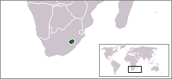
- The Kingdom of Lesotho, enclaved within South Africa
Historically, four Bantustans (or "Black homelands") of South Africa were granted nominal independence, unrecognized internationally, by the Apartheidist government from 1976 until their reabsorption in 1994. Others remained under government rule from 1948 to 1994. Being heavily partitioned, various parts of these Bantustans were true enclaves.
The United States' constitutional principle of tribal sovereignty treats federally-recognized Indian reservations as quasi-independent enclaves.
Temporary enclaves
To establish jurisdiction, the Scottish Court in the Netherlands, at Camp Zeist near Utrecht, was temporarily declared as sovereign territory of the United Kingdom under Scots law for the duration of the trial of those accused in the Lockerbie bombing, and was therefore an exclave of the United Kingdom and of Scotland, and an enclave within the Netherlands. This was also so during the appeal against the conviction. The court was first convened in 1999, and the land returned to the Netherlands in 2002.[12][13]
True exclaves
True exclave is an extension of the concept of true enclave. In order to access a true exclave from the mainland, a traveller must go through the territory of at least one other state. Examples include:
- Nakhchivan, which borders Turkey, Armenia and Iran, is an exclave of Azerbaijan.[14]
- In the United Arab Emirates, four emirates have five true exclaves: Dubai (Hatta), Ajmān (Masfout and Manama), Ras al-Khaimah (the southerly of the emirate's two non-contiguous sections), and Sharjah (Nahwa, also both a true national-level enclave and a counter-enclave).
- Llívia is an enclave and exclave of Spain surrounded by France.
- Campione d'Italia is an enclave and exclave of Italy surrounded by Switzerland.
- Büsingen am Hochrhein is an enclave and exclave of Germany surrounded by Switzerland. The shortest distance from Büsingen's borders to the main portion of German territory is only about 700 metres (about 2,300 ft).
- Likoma and Chizumulu Islands in Lake Malawi are lacustrine enclaves and exclaves of Malawi, surrounded by Mozambique territorial waters.[15]
- Sokh is the largest of several exclaves and enclaves of Uzbekistan within Kyrgyzstan.
- Vorukh is an exclave and enclave of Tajikistan within Kyrgyzstan.
Related constructs and terms
Semi-enclaves/exclaves
Semi-enclaves and semi-exclaves are areas that, except for possessing an unsurrounded sea border, would otherwise be enclaves or exclaves.[4]:116[5]:12–14 Semi-enclaves can exist as independent states that border only one other state, such as Monaco, the Gambia and Brunei. Vinokurov (2007) declares, "Technically, Portugal, Denmark, and Canada also border only one foreign state, but they are not enclosed in the geographical, political, or economic sense. They have vast access to international waters. At the same time, there are states that, although in possession of sea access, are still enclosed by the territories of a foreign state."[5]:14 Therefore, a quantitative principle applies: the land boundary must be longer than the coastline. Thus a state is classified as a sovereign semi-enclave if it borders on just one state, and its land boundary is longer than its sea coastline.[5]:14, 20–22
Vinokurov affirms that "no similar quantitative criterion is needed to define the scope of non-sovereign semi-enclaves/exclaves."[5]:14, 26[16] Examples include:
- Alaska, one of the states in the United States of America, is the largest semi-exclave in the world, separated from the US by Canada.
- Oecusse, a district on the northwestern side of the island of Timor, is a semi-enclave of East Timor.
- Ceuta and Melilla are Spanish semi-enclaves on the Mediterranean coast of Morocco.
- Temburong is a Bruneian semi-enclave surrounded by Malaysia.
- Kaliningrad Oblast is a federal subject of Russia (an oblast), a semi-exclave situated on the Baltic coast. Sea access from mainland is possible from Saint Petersburg via Gulf of Finland without passing through other states' territory.
- Cabinda (also spelled Kabinda, formerly Portuguese Congo) is a semi-exclave and a province of Angola on the Atlantic coast of southwestern Africa, separated by the only sea-access port of the Democratic Republic of the Congo.
- French Guiana (a French Overseas Department), in South America, is a semi-exclave that is bounded by Suriname, Brazil, and the Atlantic Ocean.
Subnational enclaves and exclaves
Sometimes, administrative divisions of a country, for historical or practical reasons, caused some areas to belong to one division while being attached to another.
- Dadra, enclaved within the state of Gujarat, is part of Dadra and Nagar Haveli in India.
- Pondicherry district, of the Union Territory of Puducherry, is made of 12 non-contiguous parts,[17] many of them true enclaves entirely surrounded by the state of Tamil Nadu. Before Pondicherry, along with the other territories of French India, was absorbed into India in 1954, they were enclaved within the Union of India, and before that the British Raj. Also a legacy of the French colonial period, the Mahe district is made of three non-contiguous parts enclaved within the state of Kerala.
- From 1947 to 1971, Bangladesh was a part of Pakistan as its East Pakistan exclave, separated from West Pakistan by 1,760 kilometers (1,100 miles) of India. It eventually gained independence in 1971, during the Bangladesh Liberation War.
- Before 1974, and especially before 1844, there were many exclaves of counties in England and Wales.
- The counties of Scotland before reorganisation in 1889 included dozens of exclaves. This was especially notable in the case of Cromartyshire, which was split into at least nine parts spread across Ross-shire.
- The French department of Pyrénées-Atlantiques, in the southwest of France, surrounds two enclaves of the neighbouring department of Hautes-Pyrénées.
- The French department of Vaucluse has a rather large exclave to its southeast within the Drôme department – the canton of Valréas (historically known as Enclave des Papes).
- San Colombano al Lambro is an exclave of the province of Milan at the junction between the Pavia and Lodi provinces. The exclave arose when the province of Lodi was carved out of the province of Milan, but a referendum in San Colombano indicated the locals' wish to stay in Milan. As a result, the commune is the only wine-producing area in the mostly urbanized province of Milan.
- In the United States:
- A portion of Ellis Island is an exclave of New York City within the boundaries of Jersey City, and therefore of New York State within the boundaries of New Jersey.
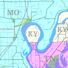
- The Kentucky Bend exists because of a meander of the Mississippi River.
- West Hollywood and Beverly Hills, California, adjoin one another, but are entirely surrounded by the city of Los Angeles.
- Jeddito, Arizona lies within a 121-square-kilometre (47 sq mi) exclave of the Navajo Nation. This exclave is surrounded by territory of the Hopi Reservation, which is itself surrounded by the Navajo Nation.
"Practical" enclaves, exclaves and inaccessible districts
The term pene-exclave was defined in Robinson (1959) as "parts of the territory of one country that can be approached conveniently – in particular by wheeled traffic – only through the territory of another country."[6]:283 Thus, a pene-exclave, although having land borders, is not completely surrounded by the other's land or territorial waters.[18]:60 Catudal (1974)[19]:113 and Vinokurov (2007)[5]:31–33 further elaborate upon examples, including Point Roberts. "Although physical connections by water with Point Roberts are entirely within the sovereignty of the United States, land access is only possible through Canada."[19]
Pene-enclaves are also called functional enclaves or practical enclaves.[5]:31 They can exhibit continuity of state territory across territorial waters but, nevertheless, a discontinuity on land, such as in the case of Point Roberts.[5]:47 Along rivers that change course, pene-enclaves can be observed as complexes comprising many small pene-enclaves.[5]:50 A pene-enclave can also exist entirely on land, such as when intervening mountains render a territory, although geographically attached, inaccessible from other parts of a country except through alien territory. A commonly cited example is the Kleinwalsertal, a valley part of Vorarlberg, Austria, that is only accessible from Germany to the north, being separated from the rest of Austria by high mountains traversed by no roads. Another example is the Spanish village of Os de Civís, accessible from Andorra.
Hence, such areas are enclaves or exclaves for practical purposes, without meeting the strict definition. Many pene-exclaves partially border the sea or another body of water, which comprises their own territorial waters (i.e., they are not surrounded by other nations' territorial waters). They border their own territorial waters in addition to a land border with another country, and hence they are not true exclaves. Still, one cannot travel to them on land without going through another country. Attribution of a pene-enclave status to a territory can sometimes be disputed, depending on whether the territory is considered to be practically inaccessible from the mainland or not.[5]:33
- Northern Ireland, an area of the United Kingdom, is bounded by the Republic of Ireland, the Irish Sea and the Atlantic Ocean.
- Equatorial Guinea's continental portion, Rio Muni, is a semi-exclave surrounded by Gabon, Cameroon and the Atlantic Ocean.
- The Northwest Angle in Minnesota is geographically separated from the rest of the state (and United States) by Lake of the Woods and is only accessible on land through Canada, via Manitoba.
- Point Roberts, Washington, is an unincorporated community in Whatcom County—located on the southernmost tip of the Tsawwassen Peninsula, south of Delta, British Columbia, Canada—that can be reached by land from the rest of the United States only by traveling through Canada.
- Vermont has two pene-enclaves with Canada. Province Point, a few kilometres to the northeast of the town of East Alburgh, Vermont, is the southernmost tip of a small promontory approximately 2 acres (1 ha) in size (45°0′48.07″N 73°11′35.72″W / 45.0133528°N 73.1932556°W). The promontory is cut through by the US-Canada border; as such the area is a practical enclave of the United States contiguous with Canada. Similarly, the southern point of Province Island (45°0′15″N 72°13′52″W / 45.00417°N 72.23111°W), a small island mostly in the Canadian province of Quebec, crosses into the American state of Vermont. It is situated in Lake Memphremagog, near Newport, Vermont.
- Walvis Bay, now part of Namibia, was a pene-exclave of the Cape Colony in German South-West Africa, created in 1878. It became part of the Cape Province of the Union of South Africa in 1910, but from 1922, it was administered as a de facto part of South-West Africa, a League of Nations Mandate.[20] In 1977, it was separated from that territory and re-integrated into the Cape Province.[21] South Africa did not relinquish sovereignty over Walvis Bay until 1994, nearly four years after Namibia's independence.[22]
- Magallanes Region of Chile, the southernmost portion of the Chilean mainland, is a practical exclave. The southernmost location that can be reached by road from the core of Chile is Villa O'Higgins in Aysén Region. Before the construction of the Carretera Austral, and its side-routes, the practical exclave included the Aysén Region and other locations such as Futaleufú.
- Isla Grande de Tierra del Fuego is a large island off southern Chile, divided into an eastern Argentinean portion and a western Chilean portion. The Argentinean portion can be considered a practical exclave, because road access is via mainland Chile and the Chilean portion of the island. Nevertheless about 95% of the human population lives in the Argentinean part.
Subnational "practical" enclaves, exclaves and inaccessible districts
- Although the Jervis Bay Territory, which occupies a coastal peninsula in Australia, is not part of the Australian Capital Territory, the laws of the ACT apply to it.[23]
- The Romanian village of Nămoloasa (Galați county) can be accessed only through Vrancea county (where there is a bridge over the Siret river), because it is separated by the Siret River from the rest of Galați county.
- The southern part of the Province of Venice, Veneto, can be reached directly from the rest of the province only by boat. By land it can be reached only traveling through the Province of Padua because territorial continuity with the main part of the province exists only through some unconnected islands and islets.
- It is not possible to drive from the northern half of County Leitrim in the Republic of Ireland to the southern half without leaving the county; Lough Allen and the River Shannon present a water barrier requiring one to drive through County Cavan to the east or County Roscommon to the west.[24]
- The community of East Kemptville, Nova Scotia, Canada, is part of the Municipality of Argyle, but it can only be reached by road from the rest of the municipality by travelling through the Municipality of Yarmouth or the Municipality of Shelburne. The latter route also requires travelling through the Municipality of Barrington.
- In the United States:
- Several portions of land on the New Jersey side of the Delaware River belong to Delaware. Within the Twelve-Mile Circle, Delaware's border extends to the low-water mark across the river. South of the Circle, the Delaware-New Jersey border follows the middle of the river and bay.
- The Eastern Shore of Virginia on the southern portion of the Delmarva Peninsula shares a border with Maryland but is only connected to the rest of Virginia by the Chesapeake Bay Bridge-Tunnel, which is part of U.S. Route 13.
- The city of Carter Lake, Iowa is separated from the rest of the state of Iowa by the Missouri River, which changed course during a flood in 1877, cutting the city off from the rest of the state. It is now only accessible through Omaha, Nebraska.
- The village of Kaskaskia, Illinois, the state's first capital, is separated from the rest of Illinois by the Mississippi River due to a flood in 1881, which shifted the river to flow east of the town, rather than west. This resulted in the only access to the town being from Missouri.
- The Upper Peninsula of Michigan is separated from the Lower Peninsula by the Straits of Mackinac, so until construction of the Mackinac Bridge, the only land routes between them were through the states of Wisconsin, Illinois, and Indiana, or through the Canadian province of Ontario,
- The Marble Hill neighborhood of Manhattan is separated from the rest of the borough by the Harlem River.
Enclaves within enclaves
It is possible for an enclave of one country to be completely surrounded by a part of another country that is itself an enclave of the first country. These enclaves are sometimes called counter-enclaves.
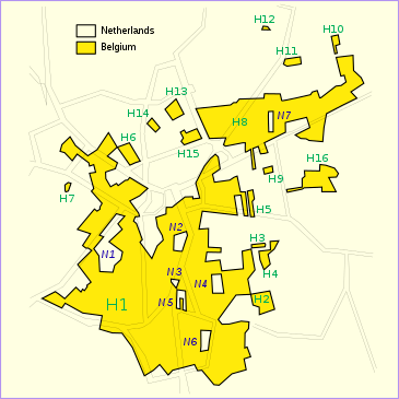
- The Dutch municipality of Baarle-Nassau has seven exclaves in two exclaves of the Belgian municipality of Baarle-Hertog.
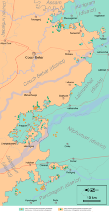
- The former complex of enclaves at Cooch Behar district included 24 second-order enclaves and one small third-order enclave called Dahala Khagrabari #51: a piece of India within Bangladesh, within India, within Bangladesh. The Indo-Bangladesh enclaves were exchanged on 31 July 2015 by the ratified Land Boundary Agreement, and Dahala Khagrabari was ceded to Bangladesh.
- Nahwa of the United Arab Emirates is surrounded by Madha, an exclave of Oman within the U.A.E.
- The Portuguese town of Estremoz is made up of two civil parishes (freguesias): the small Santo André and the big Santa Maria. Santo André corresponds to the old town (located inside the medieval walls), but excludes the citadel, which is an enclave inside the old town; the citadel belongs to Santa Maria, which also includes the entire new town (outside the walls) and the vast rural area around it. Thus, Santa Maria has an enclave (Santo André, the old town) with a second-order enclave inside it (the citadel).[25]
Ethnic enclaves
An ethnic enclave is a community of an ethnic group inside an area in which another ethnic group predominates. Ghettos, Little Italys, barrios and Chinatowns are examples. These areas may have a separate language, culture and economic system.
- Székely Land is a Hungarian ethnic enclave within Romania, with its people calling themselves Székely. Originally, the name Székely Land denoted an autonomous region within Transylvania. It existed as a legal entity from medieval times until the Austro-Hungarian Compromise of 1867, when the Székely and Saxon seats were dissolved and replaced by the county system. Along with Transylvania, it became a part of Romania in 1920, according with the Treaty of Trianon signed on 4 June 1920 at the Grand Trianon Palace in Versailles, France. In 1938–1940, during World War II, post-Trianon Hungary temporarily expanded its territory and included some additional territories that were formerly part of the pre-war Kingdom of Hungary, under Third Reich auspices, the Second Vienna Award. It was later reduced to boundaries approximating those of 1920 by the peace treaties signed after World War II at Paris, in 1947. The area was called Magyar Autonomous Region between September 8, 1952 and February 16, 1968, a Hungarian autonomous region within Romania, and today there are territorial autonomy initiatives to reach a higher level of self-governance for this region within Romania.
- There are several Serb enclaves in Kosovo where the institutions of Kosovo are not fully operational due to disputes.
Extraterritoriality
Diplomatic missions, such as embassies and consulates, as well as military bases, are usually exempted from the jurisdiction of the host country, i.e., the laws of the host nation in which an embassy is located do not typically apply to the land of the embassy or base itself. This exemption from the jurisdiction of the host country is defined as extraterritoriality. Areas and buildings enjoying some forms of extraterritoriality are not true enclaves since, in all cases, the host country retains full sovereignty. In addition to embassies, some other areas enjoy a limited form of extraterritoriality.
Examples of this include:
- Pavillon de Breteuil in France, used by the General Conference on Weights and Measures.
- United Nations headquarters in the United States, used by the United Nations.
- United Nations Office at Geneva in Switzerland, used by the United Nations.
- INTERPOL headquarters in Lyon, France, used by INTERPOL.
- NATO (political) headquarters near Evere in Haren, a part of the City of Brussels, Belgium.
- Headquarters of Allied Command Operations (NATO) at the area designated as Supreme Headquarters Allied Powers Europe (SHAPE), north of Mons, Belgium.
- Palazzo Malta and the Villa del Priorato di Malta, the headquarters of Sovereign Military Order of Malta in Rome. In addition to extraterritoriality, Italy recognizes the exercise by SMOM of all the prerogatives of sovereignty in its headquarters. Therefore, Italian sovereignty and SMOM sovereignty uniquely coexist without overlapping.[26]
- Extraterritorial properties of the Holy See in Rome and surroundings.
- By treaty of 2 November 1929, Czechoslovakia obtained the lease for 99 years of two plots of land (in the Moldauhafen and in the Saalehafen), both within the perimeter of the free port of Hamburg. Another plot, in the Peutehafen, was purchased by the Czechoslovak government in 1929; this plot lies just outside the free-port perimeter.[27][28][29]
- Saalehafen – approximately 2 ha of land on Hallesches Ufer, on the southeastern bank of the Saalehafen.
- Moldauhafen – approximately 0.5 ha of land on Dresdener Ufer, on the southeastern bank of the Moldauhafen.
- Peutehafen – the narrow peninsula between the Peutekanal and the Peutehafen dock, comprising 8.054 ha of land and 0.5 ha of water surface.
- In Szczecin, Poland, a similar provision existed following the Treaty of Versailles for Czechoslovakia to have access to the harbor, which until the end of World War II was located in Germany. From 1945, when Szczecin became part of Poland, Czechoslovakia possessed no extraterritorial rights there.[30] It appears that the German concession ceased at the end of the war and that no successor paid attention to the pre-war rights that Czechoslovakia had under the Versailles Treaty. Neither the Polish nor the occupying Russians appear to have assumed any of Germany's pre-war liabilities. Czechoslovakia gave up the rights to its territory in Szczecin under an agreement signed on 13 January 1956.[31]
- Saimaa Canal: the longitudinal half of the canal in Russia is leased by Finland until 2063. Russian law is in principle valid, but in reality Finland maintains the area.
Land owned by a foreign country
One or more parcels/holdings of land in most countries is owned by other countries. Most instances are exempt from taxes. In the special case of embassies/consulates these enjoy special privileges driven by international consensus particularly the mutual wish to ensure free diplomatic missions, such as being exempt from major hindrances and host-country arrests in ordinary times on the premises. Most non-embassy lands in such ownership are also not enclaves as fall legally short of extraterritoriality, they are subject to alike court jurisdiction as before their grant/sale in most matters. Nonetheless, for a person's offence against the property itself, equally valid jurisdiction in criminal matters is more likely than elsewhere, assuming the perpetrator is found in the prosecuting authority's homeland. Devoid of permanent residents, formally defined new sovereignty is not warranted or asserted in the examples below. Nonetheless, minor laws, especially on flag flying, are sometimes relaxed to accommodate the needs of the accommodated nation's monument.
Embassies enjoy many different legal statuses approaching quasi-sovereignty, depending on the agreements reached and in practice upheld from time-to-time by host nations. Subject to hosts adhering to basic due process of international law, including giving warnings, the enforced reduction of scope of a foreign embassy has always been a possibility, even to the point of expelling the foreign embassy entirely, usually on a breakdown of relations, in reaction to extreme actions such as espionage, or as another form of sanction. The same seems to be possible in profit-driven moving or drilling under any of the sites below, providing safeguards as the structure or a new replacement site. The same possible curtailments and alterations never apply to proper exclaves.
Examples of such land other than for diplomatic missions are:
- Napoleon's original grave in Longwood, Saint Helena, owned by France.[32]
- Victor Hugo's house in Saint Peter Port (Saint-Pierre-Port), Guernsey, owned by the city of Paris.[33]
- The Brest memorial in Brest, France is owned by the US. It commemorates World War I.
- The Normandy American Cemetery and Memorial in Normandy, France, which contains the graves of 9,386 American military dead, most of whom died during the landings and ensuing operations of World War II, owned by the United States of America.[34]
- Pointe du Hoc, the 13-hectare site of a memorial and museum dedicated to the World War II Normandy landing at Omaha Beach, France transferred to the US on 11 January 1979.[35]
- The Suvorov memorial to Russia's final Generalissimo Alexander Suvorov near Göschenen in central Switzerland, was erected 99 years after his death by the Russian Empire.[36]
- The Vimy Memorial in France, which commemorates the Battle of Vimy Ridge. The French government permanently granted the about 91 ha (220 acres) to Canada as a war memorial in 1922 in recognition of Canada's military contributions in World War I in general and at Vimy Ridge in particular.[37]
- Two cemeteries on the Outer Banks of North Carolina, United States: one on Ocracoke Island and one on Hatteras Island in the town of Buxton, are owned by the United Kingdom hosting the British seamen washed ashore after World War II U-Boat attacks of 10 April (one from the San Delfino) and 11 May 1942 (five from HMT Bedfordshire).[38] Four graves are at Ocracoke and two at Buxton; three of the bodies were never identified; one of them could be that of a Canadian seaman.[39] The plot of land at Ocracoke "has been forever ceded to England" and is maintained by the U.S. Coast Guard.[40] The plot was leased to the Commonwealth War Graves Commission for as long as the land remained a cemetery.[39] The graves on Hatteras Island are maintained by the U.S. National Park Service.[41]
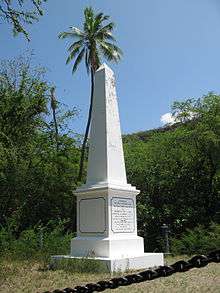
- The Captain Cook Monument at Kealakekua Bay and about 25 square feet (2.3 m2) of land around it in Hawaii, United States, the place where James Cook was killed in 1779, is owned by the United Kingdom.[42][43][44][45] An historian on the occasion of the monument's 50th anniversary recorded in 1928 that the white stone "obelisk monument [was] erected to the memory of Captain Cook, about 1876, and on land deeded outright to the British Government by Princess Likelike, sister of King Kalakaua, about the same year, so that that square is absolute British Territory."[46] Hawaii was a sovereign nation at the time. According to MacFarlane, "The land under the monument was deeded to the United Kingdom in 1877 and is considered as sovereign non-embassy land owned by the British Embassy in Washington DC. ... the Hawaiian State Parks agency maintained that as sovereign British territory it was the responsibility of the UK to maintain the site."[47]
- Tiwinza in Peru: In the 1998 peace agreement following the 1995 Cenepa War, Peru ceded to Ecuador the property, but not the sovereignty, of one square kilometer within Tiwinza (where 14 Ecuadorian soldiers were buried). Ecuador had established a frontier military outpost in Tiwinza, an area that was specified in the agreement as belonging to Peru.[48][49]

- The land under the John F. Kennedy memorial at Runnymede, United Kingdom was transferred from the Crown Estates to the United States of America by the John F. Kennedy Memorial Act 1964 (an Act of the UK Parliament);[50] however, it is in the care of the UK-based Kennedy Memorial Trust.[51]
- The Tomb of Suleyman Shah (of Suleyman Shah, the grandfather of Osman I, the founder of the Ottoman Empire) in Aleppo Governorate, Syria, is the property of Turkey. Article 9 of the Treaty of Ankara signed between France and Turkey in 1921, provides that the tomb "shall remain, with its appurtenances, the property of Turkey, who may appoint guardians for it and may hoist the Turkish flag there".[52]
Unusual cross-border transport channels
National railway passing through another state's territory
Changes in borders can make a railway that was previously located solely within a country traverse the new borders. Since diverting a railway is expensive, this arrangement may last a long time. This may mean that doors on passenger trains are locked and guarded to prevent illicit entry and exit while the train is temporarily in another country. Borders can also be in the "wrong" place, forcing railways into difficult terrain.
Examples include:
Europe
Current
- Salzburg to Innsbruck (Austria) (passes through Rosenheim, Germany). A railway line within Austria exists as well, but trains take about 1.5 hours longer than across German territory.
- Trains on the Birsig Valley Line from Basel to Rodersdorf, Switzerland, which passes through Leymen, France. It is operated by Baselland Transport and serviced by line no. 10, which continues into the Basel tram network.
- The Hochrheinbahn (Upper Rhine Railway) from Basel via Waldshut to Schaffhausen is part of the Deutsche Bahn network, and is mostly in Germany, but the two ends are in Switzerland and it is only connected with the rest of the German railway network via Switzerland. At both Basel and Schaffhausen the railway has extraterritorial status: one can travel by train to and from the rest of Germany without going through Swiss customs. See Basel Badischer Bahnhof.
- Trains from Neugersdorf, Saxony to Zittau pass Czech territory at Varnsdorf, while Czech trains from Varnsdorf to Chrastava pass through German territory at Zittau, and then a small part of Polish territory near the village of Porajów.
- Trains from Görlitz to Zittau, Germany, pass the border river Neisse several times (see Oder–Neisse line); the railway station for Ostritz, Germany, lies in Krzewina Zgorzelecka, Poland.
- Belgrade–Bar railway crosses into Bosnia and Herzegovina for 9 kilometres (5.6 mi), between stations Zlatibor and Priboj (both in Serbia). There is one station, Štrpci, but there are no border-crossing facilities, and trains do not call at the station.
- The Knin – Bihać railway between Croatia and Bosnia is split by the Croatian–Bosnian border several times. Similarly, the Savski Marof – Imeno railway was split by the Slovenian–Croatian border several times.
- Lučenec – Veľký Krtíš line in Slovakia passes through Hungary from Ipolytarnóc to Nógrádszakál.
- The local trains on the Burgenlandbahn in Austria cross the area of Hungary at Sopron. During the era of the Iron Curtain, the trains had their doors locked as they traversed Hungarian territory.
- The line from Ventimiglia to Limone Piemonte, Italy, via Breil-sur-Roya, France.
- The railway between France and Italy briefly leaves France to enter Monaco in a 150-metre tunnel before entering France once more.
- For the Belgian Vennbahn (now a cycleway) narrow strips of Belgian territory were created running through Germany, creating five German exclaves.
- The former Soviet republics have numerous examples:
- Semikhody – Chernihiv line of Ukraine passes through Belarus territory.[53]
- Belarus/Lithuania: Adutiškis railway station straddles the Lithuania/Belarus border. Trains pass through Lithuanian territory while traveling to and from Belarus, and platforms are in both Belarus and Lithuania. The station is now mainly used for freight.
- Druzhba – Vorozhba line of Ukraine passes through Russian territory.[53]
- In 2009, Russia and Kazakhstan agreed to transfer ownership of a cross-border section of line.
Historic
- During the Cold War, underground lines in West Berlin ran under parts of East Berlin. Ghost stations (German: Geisterbahnhöfe) were stations on Berlin's U-Bahn and S-Bahn metro networks that were closed during this period of Berlin's division.
Proposals
Africa
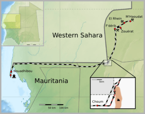
- Due to inability to agree in 1963 on a shorter route through easy terrain, the iron ore railway in Mauritania originally had to use a longer route through a tunnel (built through 2 km of solid granite) near Choum to avoid the territory of Spanish Sahara. The tunnel is no longer in use and trains now use the shorter route through 5 km of Western Saharan territory controlled by the Polisario Front.
- In 2012, a railway route from Angola proper to the enclave of Cabinda has to cross not only the Congo River but also the territory of the Democratic Republic of the Congo.
- In 2013, the shortest railway route from coal mines at Tete to a port at Nacala passes through Malawi. A route through all-Mozambique territory is circuitous.
- In 1928, Congo (Belgium) and Angola (Portugal) exchanged some land to facilitate the new route of the railway to Congo-Kinshasa.[54]
Middle East
The Americas
- Bolivia is landlocked and has no access to the sea, but a rail route runs through Chile from La Paz to the port of Arica on the Pacific Ocean. The rail route was built by Chile under the Treaty of Peace and Friendship of 1904 between Chile and Bolivia, with the Bolivian section transferred to Bolivia after 15 years. Bolivia enjoyed duty-free use of the railway and the ports connected.
- The International Railway of Maine was a railroad constructed by the Canadian Pacific Railway (CPR) between Lac-Mégantic, Quebec, and Mattawamkeag, Maine, closing a key gap in the railway's transcontinental main line to the port of Saint John, New Brunswick.[55] The railway was however, at all times under American jurisdiction with the borders of the United States.
- In order to avoid such a trans-border arrangement, the United States made the Gadsden Purchase of land from Mexico, on which it was planned to build a southern route for the transcontinental railroad. Owing to the topography of the area, acquisition of the land was the only feasible way to construct such a railroad through the southern New Mexico Territory.
Highway of one state passing through another state's territory
This arrangement is less common as highways are more easily re-aligned. Examples include:
Africa
- Congo Pedicle road: built to provide access for Zambia's Luapula Province to the Copperbelt through 70 kilometres (43 mi) of territory of the DR Congo, requiring a change in driving on the left to driving on the right.
- In Guinea, where 20 km long tunnel(s) through a hillspur at Naigaya (elevation 411 metres (1,348 ft)), Sicourou, Bokariadi and Feraya might be avoided by crossing the border into Sierra Leone at Yana (elevation 87 metres (285 ft)).
- Senegal is practically and inconveniently divided in two by the sovereign territory of Gambia. The easiest way to travel from northern Senegal to the southern Casamance region is through Gambia via the Trans-Gambia Highway, with a connecting ferry being the only way to cross the Gambia River. The fare for the ferry crossing is a source of contention between the two countries.[56][57] In 2015, a road bridge is under construction.[58]
Asia
- The road from Dubai to the tourist spot of Hatta, an exclave of the emirate of Dubai, passes through a small stretch of Omani territory.
- The highway between Bishkek and Issyk Kul, both in Kyrgyzstan, skirts the border with Kazakhstan, with the highway and the border crossing each other for short distances at various points.
Europe
- Various roads crossing the border back and forth between the Republic of Ireland and Northern Ireland. The N54 in County Monaghan, Ireland twice becomes the A3 in County Fermanagh, NI, before continuing as the N54. Similarly, the N53 in Monaghan passes through County Armagh, NI as the A37, before resuming as the N53 at the border between Monaghan and County Louth, Ireland.[59] No national or county border signs are present.
- Between 1963 and 2002 the N274 road from Roermond to Heerlen, part of Dutch territory, passed through the German Selfkant, which had been annexed by the Netherlands after the Second World War but returned to Germany in 1963.
- Close to Narvik, a road from Norway twice enters and leaves Swedish territory, following the southern shore of the Kjårdavatnet lake. It does not connect with any other Swedish road in either location before it enters Norwegian land once more.[60][61]
- Road 402 between Podsabotin and Solkan in Slovenia, built when Slovenia was a state of Yugoslavia, passes through part of Italy. The road is confined by high concrete walls topped by fences; as Slovenia and Italy are now both signatories to the Schengen agreement, the barriers are little more than historical curiosities.
- The Saatse Boot Road in Estonia, between the villages of Lutepää and Sesniki, passes through Russian territory. The stretch of road passing through Russia is flanked by barbed wire fences and guard towers. Stopping and/or getting out of one's vehicle on the stretch of road is forbidden; the rule is enforced by Russian border guards.
- The D8 coastal highway of Croatia passes through a small section of Herzegovina territory, at the Herzegovinian town of Neum, as it heads south from Split to Dubrovnik.
The Americas
- East Richford Slide Road in the US state of Vermont crosses in to the Canadian province of Québec for a distance of approximately 100 meters (300 feet) before returning to the United States.[62]
Subnational highway passing through other internal territory
- India
- The highway connecting Guwahati (capital of Assam state) to Silchar (a city in Barak valley of Assam) passes through Meghalaya state.
- One has to travel through part of West Bengal while travelling from Jamshedpur (Tatanagar), Jharkhand to few other cities of Jharkahand like Ranchi or Dhanbad.
- Kota, a city in Rajasthan surrounded by territory of Madhya Pradesh, is connected to other parts of Rajasthan by roads passing through Madhya Pradesh.
- Gwalior (Madhya Pradesh) is connected to few other cities of Madhya Pradesh by highways passing through Uttar Pradesh, covering the city of Jhansi.
- United States:
- Interstate 684, connecting various points in New York State, passes through Connecticut near Kensico Reservoir and Westchester County Airport but is maintained entirely by New York State. Motor vehicles cannot enter from nor exit to Connecticut roads, even though a portion of the highway is owned by Connecticut.
- A portion of New York State Route 17/Interstate 86 passes through South Waverly, Pennsylvania but is maintained entirely by New York State. This includes the roadway and traffic lights at the interchange with US Route 220 and a short portion of Pennsylvania Route 199. Nevertheless, Pennsylvania police enforce traffic laws on this short stretch, where there is one overpass built and owned by Pennsylvania.
- A 2.0 miles (3.2 km) portion of New Hampshire Route 153 runs along the border with and briefly passes through Parsonsfield, Maine as it sweeps around the eastern shore of Province Lake.
- Minnesota State Highway 23 passes through about 0.57 miles (0.92 km) of Wisconsin just west of Duluth, Minnesota.[63][64] Maintained by the Minnesota Department of Transportation, it intersects only a few dead-end local roads while in Wisconsin. No state line signs are present.[63][65]
- Hopkins Road north of Newark, Delaware, briefly enters Pennsylvania where the Twelve-Mile Circle meets the Mason–Dixon Line. The road is maintained by Delaware, and it appears that at one time Arc Corner Road in Pennsylvania may have intersected here. Further east, Beaver Dam Road enters Chadds Ford Township, Pennsylvania at the intersection of Beaver Valley Road and re-enters Delaware about 0.5 miles later. The section of road in Pennsylvania is in rough shape, and it is unclear who is supposed to maintain this section.
- Turkey:
Border transport infrastructure
Europe
- Several bridges cross the rivers Oder and Neisse between Germany and Poland. To avoid needing to coordinate their efforts on a single bridge, the two riparian states assign each bridge to one or the other; thus Poland is responsible for all maintenance on some of the bridges, including the German side, and vice versa.[66]
- The Hallein Salt Mine crosses from Austria into Germany. Under an 1829 treaty Austria can dig under the then-Kingdom of Bavaria. In return some salt has to be given to Bavaria, and up to 99 of its citizens can be hired to work in the Austrian mine.[67]
- The twin town of TornioHaparanda or HaparandaTornio lies at the mouth of river Tornio, Tornio on the Finnish side and Haparanda on the Swedish side. The two towns have a common public transportation, as well as cultural services, fire brigade, sports facilities etc.
- The Basel Badischer Bahnhof is a railway station in the Swiss city of Basel. Although situated on Swiss soil, because of the 1852 treaty between the Swiss Confederation and the state of Baden (one of the predecessors of today's Germany), the largest part of the station (the platforms and the parts of the passenger tunnel that lead to the German/Swiss checkpoint) is treated administratively as an inner-German railway station operated by the Deutsche Bahn. The shops in the station hall, however, are Swiss, and the Swiss franc is used as the official currency there (although the euro is universally accepted). The Swiss post office, car rental office, restaurant and a cluster of shops are each separately located wholly within a surrounding station area that is administered by the German railway.[68] The customs controls are located in a tunnel between the platforms and the station hall; international trains which continue to Basel SBB usually have on-board border controls.
Asia
- The Hong Kong–Shenzhen Western Corridor on the Hong Kong–mainland China border: the immigration control points for Hong Kong (Shenzhen Bay Control Point) and mainland China (Shenzhen Bay Port) are co-located in the same building on the Shenzhen side of the bridge in an effective pene-exclave. The Hong Kong portion of the service building and the adjoining bridge are leased to Hong Kong, and are under Hong Kong's jurisdiction for an initial period until 30 June 2047.
- The Mainland Port Area in Kowloon High Speed Railway Station in downtown Hong Kong is under the jurisdiction of the Mainland Chinese authorities and courts. The 30 km long underground tunnel to the border is under Hong Kong jurisdiction, however, the train compartments of any train in operation (that is carrying passengers to or from the Mainland) are subject to Mainland Laws and jurisdiction.[69]. This arrangement was created to allow for immigration clearance to occur in Hong Kong for all trains travelling to and from the Mainland of China.
- As a legacy of the British colonial period, the Malaysian rail network had its southern terminus at Tanjong Pagar railway station in central Singapore. The land on which the station and the rail tracks stood was leased to Keretapi Tanah Melayu, the Malaysian state railway operator. Consequently, Malaysia had partial sovereignty over the railway land.[70] Passengers had to clear Malaysian customs and immigration checks at Tanjong Pagar before boarding the train to Malaysia, even after Singapore shifted its border control facility to the actual border in 1998 and objected to the continued presence of Malaysian officials at the station. After a 20-year long dispute, the station was closed in 2011 and the railway land reverted to Singapore.[70] A remnant of the rail corridor is still in use; KTM trains now terminate at Woodlands Train Checkpoint in northern Singapore near the border, which houses Malaysian and Singaporean border controls for rail passengers.[71]
See also
Lists:
Notes
- 1 2 Raton, Pierre (1958). "Les enclaves". Annuaire français de droit international. p. 186.
- 1 2 3 Melamid, Alexander (1968). Sills, David, ed. "Enclaves and Exclaves". International Encyclopedia of the Social Sciences. 5. The Macmillan Company & Free Press.
- 1 2 "Exclave". Webster's Encyclopedic Unabridged Dictionary of the English Language. 1989. p. 497.
- 1 2 3 4 Rozhkov-Yuryevsky, Yuri (2013). "The concepts of enclave and exclave and their use in the political and geographical characteristic of the Kaliningrad region". Baltic Region (2): 113–123. doi:10.5922/2079-8555-2013-2-11.
- 1 2 3 4 5 6 7 8 9 10 11 12 13 14 Vinokurov, Evgeny (2007). The Theory of Enclaves. Lexington Books, Lanham, MD.
- 1 2 Robinson, G. W. S. (September 1959). "Exclaves". Annals of the Association of American Geographers. 49 (3, [Part 1]): 283–295. doi:10.1111/j.1467-8306.1959.tb01614.x. JSTOR 2561461.
- 1 2 Le Grand Robert, Dictionnaire de la Langue Française, 2001, vol. III, p. 946.
- ↑ Webster's Encyclopedic Unabridged Dictionary of the English Language. 1989. p. 1304.
Servitude: Law. A right possessed by one person with respect to another's property, consisting either of a right to use the other's property, or a power to prevent certain uses of it.
- ↑ "Government Jobs in BSNL : 01 Jobs Opening". jobresultsnic.in. Archived from the original on 2014-12-24. Retrieved 2014-02-24.
- ↑ As can be seen on 18th. century maps of Germany and other European countries by British cartographers and publishers such as R. Wilkinson.
- ↑ "Berlin Exclaves". Retrieved 2013-05-02.
- ↑ "Uncertain future for Camp Zeist". BBC News. 2002-03-14. Retrieved 2011-01-30.
The former military base at Camp Zeist in Holland has been under Scottish jurisdiction for more than three years. The base was converted into a prison and a courtroom to provide the venue for the Lockerbie trial – the largest and most expensive ever conducted under Scots law.
- ↑ Statutory Instrument 1998 No. 2251 The High Court of Justiciary (Proceedings in the Netherlands) (United Nations) Order 1998
- ↑ "Assembly of Turkish American Associations". Ataa.org. Retrieved 2014-02-24.
- ↑ "Malawi Tourism Guide". MalawiTMC. Retrieved 2017-05-08.
- ↑ Vinokurov (2007), p. 29, also refers to semi-exclaves as a type of "mere exclave with sea connection to the mainland."
- ↑ "Map showing the existing police station limits". Retrieved 2013-09-30.
- ↑ Melamid (1968) states, "Contiguous territories of states which for all regular commercial and administrative purposes can be reached only through the territory of other states are called pene-enclaves (pene-exclaves). These have virtually the same characteristics as complete enclaves (exclaves)."
- 1 2 Catudal, Honoré M. (1974). "Exclaves". Cahiers de géographie du Québec. 18 (43): 107–136. doi:10.7202/021178ar.
- ↑ Succession of States and Namibian territories, Y. Makonnen in Recueil Des Cours, 1986: Collected Courses of the Hague Academy of International Law, Academie de Droit International de la Haye, Martinus Nijhoff Publishers, 1987, page 213
- ↑ The Green and the dry wood: The Roman Catholic Church (Vicariate of Windhoek) and the Namibian socio-political situation, 1971-1981, Oblates of Mary Immaculate, 1983, page 6
- ↑ No. 203 of 1993: Transfer of Walvis Bay to Namibia Act, 1993. Archived 2016-02-23 at the Wayback Machine.
- ↑ "Jervis Bay Territory Governance and Administration". Although the Jervis Bay Territory is not part of the Australian Capital Territory, the laws of the ACT apply, in so far as they are applicable and, providing they are not inconsistent with an Ordinance, in the Territory by virtue of the Jervis Bay Acceptance Act 1915. The Department of Regional Australia, Local Government, Arts and Sport. Retrieved 17 January 2013.
- ↑ "Google Maps route out of the county from one point on the county border to the other here".
- ↑ Instituto Geográfico do Exército: Territory of Santa Maria (Estremoz)
- ↑ Arocha, Magaly (May 1999). "La Orden de Malta y su Naturaleza Jurídica (The Order of Malta and Its Legal Nature)". Caracas, Distrito Capital, Venezuela: Analítica.com. Retrieved October 1, 2012.
- ↑ "Notification of the Ministry of Transport and Communications of the Czech Republic". 20 August 2001. Retrieved 2013-10-26.
- ↑ Siebeck, Jürgen (23 October 2002). "Is Bohemia the sea?". Retrieved 2013-10-26.
- ↑ Vališ, Zdeněk (28 April 2005). "Czech harbor in Hamburg, waiting for resurrection". Retrieved 2013-10-26.
- ↑ "Czech leased areas in Hamburg and Stettin". Retrieved 2013-10-26.
- ↑ "The Transport Agreement between the Czechoslovak Republic and the Polish People's Republic of 13 January 1956". Archived from the original on 2013-10-29. Retrieved 2013-10-26.
- ↑ "domaines français de Sainte-Hélène". Domfrance.helanta.sh. Archived from the original on 2011-03-25. Retrieved 2012-09-02.
- ↑ "Guernesey : Hauteville House". Paris.fr. 2012-08-28. Archived from the original on 2010-06-26. Retrieved 2012-09-02.
- ↑ Source:American Battle Monument Commission Archived 2005-11-26 at the Wayback Machine.
- ↑ "The American Battle Monuments Commission". "The site, preserved since the war by the French Committee of the Pointe du Hoc, which erected an impressive granite monument at the edge of the cliff, was transferred to American control by formal agreement between the two governments on 11 January 1979 in Paris, with Ambassador Arthur A. Hartman signing for the United States and Secretary of State for Veterans Affairs Maurice Plantier signing for France". Retrieved October 29, 2012.
- ↑ "Suworow monument". Andermatt-Urserntal Tourism. Retrieved 2017-02-17. The 449 m² of rocks and 114 m² of access road is Parcel No. 725 of the land register of Andermatt, owned by the Russian Embassy in Berne. As in almost all examples in this list the parcel remains fully, in jurisdiction, that of the host country.
- ↑ "Canada And Vimy Ridge – Background Information – Veterans Affairs Canada". Archived from the original on 2013-04-18. Retrieved 2012-04-09.
- ↑ Hickam, Homer H. (1996). Torpedo Junction: U-Boat War Off America's East Coast, 1942. Naval Institute Press. pp. 202–207. ISBN 1-55750-362-1.
- 1 2 "British Cemetery at Ocracoke, North Carolina". Retrieved 2013-02-24.
- ↑ "Historic Ocracoke Village – A Walking Tour". Retrieved 2013-02-24.
- ↑ "British Cemeteries". Retrieved 2013-02-24.
- ↑ Horwitz, Tony. Oct. 2003, Blue Latitudes: Boldly Going Where Captain Cook Has Gone Before, Bloomsbury, ISBN 0-7475-6455-8
- ↑ Erickson, Lt Clayton, RCN (2012). "Captain Cook Monument at Kealakekua Cleaned and Repaired". Cook's Log. 35 (4). p. 38. Retrieved 2013-02-23.
- ↑ "Canadian Crew Cleans Cook Monument". 30 August 2012. Archived from the original on 2013-09-21. Retrieved 2013-02-23.
- ↑ Harris, Francis (22 Jul 2006). "Don't mention the murder – how Hawaii forgot Capt. Cook". The Daily Telegraph. London. Retrieved 2013-02-23.
- ↑ Taylor, Albert P. "HOW HAWAII HONORED CAPTAIN COOK, R.N., IN 1928". p. 29. Retrieved 2013-02-23.
- ↑ MacFarlane, John M. (2012). "The Captain Cook Memorial at Kealakakua Bay Hawaii". Retrieved 2013-02-23. (Fellow of Royal Geographic Society)
- ↑ "Cronologia de la Historia Resumida del Ecuador". Retrieved 15 Feb 2017.
- ↑ Jimenez, Carmen (27 Oct 1998). "Los presidentes de Perú y Ecuador firman la paz en Brasilia y delimitan su frontera". El País. Retrieved 15 Feb 2017.
- ↑ "John F. Kennedy Memorial Act". Google docs [unofficial copy]. Retrieved 2012-06-16.
- ↑ Evans, D. M. Emrys (1965). "John F. Kennedy Memorial Act, 1964". The Modern Law Review. 28 (6): 703–706. JSTOR 1092388. (free registration required to read relevant text on page 704)
- ↑ "Franco-Turkish agreement of Ankara" (PDF) (in French and English). Retrieved 8 August 2014.
- 1 2 Railway Gazette International April 2008 p 240
- ↑ [Railways Africa 2014 issue 5, p29]
- ↑ Johnson, Ron (1985). The Best of Maine Railroads. Portland Litho.
- ↑ "Senegal may tunnel under Gambia". BBC News. 2005-09-21.
- ↑ http://www.afdb.org/fileadmin/uploads/afdb/Documents/Project-and-Operations/Multinational__The_Gambia-Senegal__-_AR_-_Construction_of_the_Trans-Gambia_Bridge_and_Cross_Border_Improvement_.pdf
- ↑ "Office of The Gambian President: State House Online: Yahya A.J.J. Jammeh". statehouse.gm. Archived from the original on 2015-08-08.
- ↑ 2006 Road Atlas Ireland, AA, pp. 36–37
- ↑ Jan S. Krogh's Geosite on Sørdalen valley
- ↑ "Driving directions". Google maps. Google. Retrieved 21 May 2015.
- ↑ Google Maps
- 1 2 Bessert, Christopher J. "Highways 20–29". Wisconsin Highways. Retrieved July 7, 2011.
- ↑ Riner, Steve. "Details of Routes 1–25". The Unofficial Minnesota Highways Page. Retrieved July 7, 2011.
- ↑ "Map of Douglas County, Wisconsin" (PDF). Archived from the original (PDF) on 2014-03-17. Retrieved 2014-09-08.
- ↑ Railway Gazette: Border bridges rebuilt Archived May 3, 2008, at the Wayback Machine.
- ↑ The log of the Water Lily, p. 84. Books.google.com. Retrieved 2014-02-24.
- ↑ "Ihr Bahnhof Basel Bad Bf" (PDF). Archived from the original (PDF) on 2007-09-30. Retrieved 2013-02-26.
- ↑ [http://www.hklii.hk/cgi-bin/sinodisp/eng/hk/legis/ord/632/ Guangzhou-Shenzhen-Hong Kong Express Rail Link (Co-Location) Ordinance
- 1 2 "From The Straits Times Archives: Malayan Railway land in Singapore". The Straits Times. 31 October 2014. Retrieved 26 February 2015.
- ↑ "KTM Tg Pagar station will move to Woodlands in S'pore July 1, 2011 (Update)". The Star (Malaysia). 24 May 2010. Retrieved 26 February 2015.
References
- Robinson, G. W. S. (September 1959). "Exclaves". Annals of the Association of American Geographers. 49 (3, [Part 1]): 283–295. doi:10.1111/j.1467-8306.1959.tb01614.x. JSTOR 2561461.
External links
| Look up enclave in Wiktionary, the free dictionary. |
| Wikisource has the text of the 1911 Encyclopædia Britannica article Enclave. |
| Wikimedia Commons has media related to Exclaves and enclaves. |