Jhansi
| Jhansi | |
|---|---|
| Metropolis | |
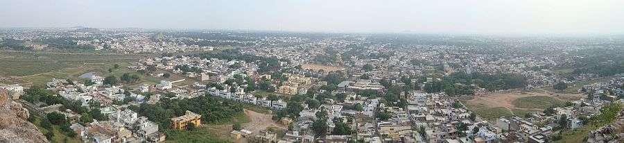
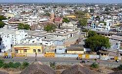 Jhansi skyline | |
Nickname(s):
| |
 Jhansi | |
| Coordinates: 25°26′55″N 78°34′11″E / 25.44862°N 78.56962°ECoordinates: 25°26′55″N 78°34′11″E / 25.44862°N 78.56962°E | |
| Country |
|
| State | Uttar Pradesh |
| Region | Bundelkhand |
| District | Jhansi |
| Founded by | Raja of Orchha |
| Named for | Orchha Cantonment |
| Government | |
| • Mayor | Ram Teerth Singhal (BJP) |
| • Assistant Superintendent | Dinesh Kumar Singh |
| • Member of Parliament | Uma Bharti (Bhartiya Janta Party) |
| Elevation | 285 m (935 ft) |
| Population (2011 census) | |
| • Metropolis | 505,693[1] |
| • Rank | 57 |
| • Metro | 547,638[1] |
| Languages | |
| • Official | Hindi |
| • Other | Bundeli |
| Time zone | UTC+5:30 (IST) |
| PIN | 284001-2-3-4 |
| Telephone code | 0510 |
| Vehicle registration | UP-93 |
| Sex ratio | ♂ 0.905 : ♀ 1.000 |
| Literacy | 83.02%[1] |
| Avg. summer temperature | 47 °C (117 °F) |
| Avg. winter temperature | 4.0 °C (39.2 °F) |
| Website |
www |
Jhansi (![]()
The original walled city grew around its stone fort which crowns a neighbouring rock. The ancient name of the city was Balwantnagar. From 1817 to 1854, Jhansi was the capital of the princely state of Jhansi which was ruled by Maratha rajas. The state was annexed by the British Governor General in 1854; Damodar Rao's claim to the throne was rejected but Rani Lakshmibai ruled it from June 1857 to June 1858.
Jhansi is well connected to all other major towns in uttar Pradesh by road and railway networks. The National Highways Development Project has supported development of Jhansi. Srinagar to Kanyakumari North-South corridor passes through Jhansi as does the East-West corridor; consequently there has been a sudden rush of infrastructure and real estate development in the city. A greenfield airport development has been planned.[2] On 28 August, 2015 Jhansi was selected among 98 cities for smart city initiative by Government of India.[3][4][5]
Etymology

According to a legend the Raja of Orchha was sitting on the roof of his palace with his friend, the Raja of Jaitpur, and asked the latter whether he could discern this new fort that he had built on Bangara hill, and he replied that he could see it 'jhainsi' (meaning rather indistinct). This name 'Jhansi' in course of time became corrupted to 'Jhansi'. It was one of the most strategically situated forts of central India being built on an elevated rock rising out of the plain and commanding the city and the surrounding country.
History
In the 18th century, the town of Jhansi served as the capital of a Maratha province and later the Princely State of Jhansi from 1804 till 1853, when the territory became a part of British India.
Demographics
| Historical population | ||
|---|---|---|
| Year | Pop. | ±% |
| 1871 | 30,000 | — |
| 1881 | 33,000 | +10.0% |
| 1891 | 53,779 | +63.0% |
| 1901 | 55,724 | +3.6% |
| 1911 | 70,200 | +26.0% |
| 1921 | 66,400 | −5.4% |
| 1931 | 76,700 | +15.5% |
| 1941 | 103,300 | +34.7% |
| 1951 | 127,400 | +23.3% |
| 1961 | 140,200 | +10.0% |
| 1971 | 173,300 | +23.6% |
| 1981 | 231,300 | +33.5% |
| 1991 | 300,850 | +30.1% |
| 2001 | 426,198 | +41.7% |
| 2011 | 505,693 | +18.7% |
| Source: 1871-1891 - The Imperial Gazetteer of India[6] 1901-1981 - Populstat.info[7] 1991-2011 - Citypopulation.de[8] | ||
According to the 2011 census, Jhansi has a population of 1,998,603, its urban agglomeration a population of 547,638. The literacy rate of Jhansi is 83.02%, higher than the state average of 67.68%. The sex ratio is 890 females for every 1000 males.[9] Jhansi city has 231st rank among the most populated cities of India, according to the 2011 census.
Jhansi Cantonment
According to the Indian Census of 2001[10] there were 21,917 people in Jhansi Cantonment, of whom 56% were male and 44% female (men 12,264; women 9,653; children 2,612). The rate of literacy was 80%.
Geography and climate
Jhansi is located at 25.4333 N 78.5833 E. It has an average elevation of 284 metres (935 feet).[11] Jhansi lies on the plateau of central India, an area dominated by rocky relief and minerals underneath the soil. The city has a natural slope in the north as it is on the south western border of the vast Tarai plains of Uttar Pradesh and the elevation rises on the south. The land is suitable for species of citrus fruit and crops include wheat, pulses, peas, and oilseeds. The region relies heavily on Monsoon the rains for irrigation purposes. Under an ambitious canal project (the Rajghat canal), the government is constructing a network of canals for irrigation in Jhansi and Lalitpur and some part of Madhya Pradesh. The trade in agricultural products (including grain and oilseeds) is of great economic importance.[12] The city is also a centre of brassware manufacture.[13]
Climate
Being on a rocky plateau, Jhansi experiences extreme temperatures. Winter begins in October with the retreat of the Southwest Monsoon (Jhansi does not experience any rainfall from the Northeast Monsoon) and peaks in mid-December. The mercury generally reads about 4 degrees minimum and 21 degrees maximum. Spring arrives by the end of February and is a short-lived phase of transition. Summer begins by April and summer temperatures can peak at 47 degrees in May. The rainy season starts by the third week of June (although this is variable year to year). Monsoon rains gradually weaken in September and the season ends by the last week of September. In the rainy season, the average daily high temperature hovers around 36 degrees Celsius with high humidity. The average rainfall for the city is about 900 mm per year, occurring almost entirely within the three-and-a-half months of the Southwest Monsoon. In summer Jhansi experiences temperatures as high as 45-47 degrees and in winter the temperatures fall as low as 0-1 degrees (recorded in winter 2011).
| Climate data for Jhansi (1971–2000) | |||||||||||||
|---|---|---|---|---|---|---|---|---|---|---|---|---|---|
| Month | Jan | Feb | Mar | Apr | May | Jun | Jul | Aug | Sep | Oct | Nov | Dec | Year |
| Record high °C (°F) | 33.8 (92.8) |
39.4 (102.9) |
43.3 (109.9) |
46.2 (115.2) |
48.0 (118.4) |
47.8 (118) |
45.6 (114.1) |
42.2 (108) |
40.6 (105.1) |
40.6 (105.1) |
38.1 (100.6) |
33.1 (91.6) |
48.0 (118.4) |
| Average high °C (°F) | 23.3 (73.9) |
26.9 (80.4) |
33.3 (91.9) |
39.3 (102.7) |
42.3 (108.1) |
40.5 (104.9) |
34.0 (93.2) |
32.2 (90) |
33.3 (91.9) |
33.9 (93) |
29.6 (85.3) |
24.5 (76.1) |
32.9 (91.2) |
| Average low °C (°F) | 7.4 (45.3) |
10.3 (50.5) |
15.8 (60.4) |
21.9 (71.4) |
26.3 (79.3) |
27.3 (81.1) |
24.6 (76.3) |
23.7 (74.7) |
22.8 (73) |
19.1 (66.4) |
13.2 (55.8) |
8.5 (47.3) |
18.4 (65.1) |
| Record low °C (°F) | 1.2 (34.2) |
0.6 (33.1) |
5.3 (41.5) |
10.1 (50.2) |
15.1 (59.2) |
18.5 (65.3) |
20.3 (68.5) |
18.3 (64.9) |
16.7 (62.1) |
10.7 (51.3) |
1.1 (34) |
0.3 (32.5) |
0.3 (32.5) |
| Average precipitation mm (inches) | 9.2 (0.362) |
9.6 (0.378) |
7.7 (0.303) |
2.3 (0.091) |
13.9 (0.547) |
85.0 (3.346) |
270.4 (10.646) |
286.2 (11.268) |
165.3 (6.508) |
31.8 (1.252) |
6.3 (0.248) |
3.6 (0.142) |
891.3 (35.091) |
| Average rainy days | 0.9 | 1.0 | 0.7 | 0.5 | 1.3 | 4.9 | 12.3 | 13.1 | 7.0 | 1.6 | 0.5 | 0.5 | 44.2 |
| Source: India Meteorological Department (record high and low up to 2010)[14][15] | |||||||||||||
Tourism
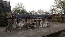
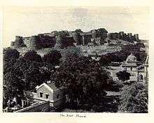
Jhansi Fort
The early 17th century fort was made by Raja Bir Singh on top of a hill known as Bangara as an army stronghold. The Karak Bijli cannon is in the fort. There is a museum nearby which has a collection of sculpture and provides an insight into the history of Bundelkhand. Extending over 15 acres, this fort is a great example of the north Indian style of architecture.
Government Museum and Rani Mahal
In the Government Museum there are collections of weapons, statues, dresses and photographs that represent the Chandela dynasty and a picture gallery of the Gupta period. There are also terracottas, bronzes, manuscripts, paintings and coins. The Government Museum specifically keep the belonging of the Rani of Jhansi, for example: her sword, armour and utensils. The museum is closed on Mondays and the second Saturday of every month.
The Rani Mahal was the palace of Rani Lakshmi Bai and has now been converted into a museum. It houses a collection of archaeological remains of the period between the 9th and 12th centuries AD.
Karguanji Jain Temple
This is most popular jain Mandir. Shri Karguvanji Atishaya Kshetra is the only 5 km ahead from Jhansi city opposite Gate No. 2 of Medical College in the beautiful valley of Karguvan Village on Jhansi–Kanpur Road, Kshetra is about 700 years old. Here 6 idols of Black Stone are installed in a basement, which is situated in the midst 9 acres of land surrounded by a rampart. 200 years ago, at the time of Peshavas, Jhansi was famous as Balvant Nagar. One day a person was carrying broken idols in a bullock cart to drop idols in water, stopped here. After trying again & again the cart did not move ahead. In the same day night a famous man of Balvant Nager, Shri Singhai Nanheju saw dream and came to know that at a place where cart stayed. There were various idols hidden underground. In the next morning Shri Nanheju informed to king about dream of night, after discussion digging at that place was decided and thus the ancient idols were recovered under the basement. The King donated 9 acres of land for temple there, at which rampart & well constructed and a beautiful garden was developed. Here six ancient idols of V.S. 1345 are installed and a big idol of Lord Mahaveer was also installed by Shri Nanheju with organizing Panch Kalyanaka Pratishtha Mahotsava.
Other places of interest
- Temples: Iskcon Temple, Laxmi Temple; Shri Kali Temple; Kaimasan mata Temple
- Christian churches: Sacred Heart Church; St. Jude's Shrine; St Antony's Cathedral
- Gangadhar Rao-Ki-Chhatri (tomb)
- Laxmi Bai Park; Narayan Bagh; Jari Ka Math; Barua Sagar & Fort; Garhmau Lake; Herbal Garden
Culture
Festivals
- Jhansi Mahotsav takes place in the February-March and lasts for about one week. The main aim behind this festival is to showcase the arts and culture of the town. The perfect place for poetry lovers, it commemorates the memories of the legends who had excelled in the field of Poetry. A number of cultural programs are organized at the festival that includes folk songs, dances, mushairas, ghazals, alha songs, suata and rai dance along with different competitions, a food festival, a handicraft fair, etc. The state government of Jhansi’s tourism department organizes the Jhansi Mahotsava. This festival is a week long event. You get to see dance and music performances during the festival that highlight the culture of Bundelkhand.
- Birthday celebration of Rani Laxmibai
- Craft Mela
- Ayurveda Jhansi Mahotsav also serves as a promoter of the Ayurvedic system of healing and the use of Ayurveda for general well being. Hence the festival is also known as "Ayurved Jhansi Mahotsav". Other attractions of the festival include handicraft fair and traditional folk performances by local artists. Last but not the least, the festival is intended to advertise the state of Uttar Pradesh as one of the most accessible destinations for health tourism.
- There is the state vegetables and flowers exhibition that are worth visiting while in Jhansi. This is basically an exhibition that lasts three days and is organized by the state government. The exhibition is held in the state gardens of Narayan bagh during the month of February. On visiting the exhibition, you find different types of vegetables, fruits and flowers found in and around Jhansi.
Jhansi in movies
- Movies and television
- Jhansi Ki Rani
- Raavan
- Badrinath Ki Dulhania
- Hollywood Project, a movie on Lakshmibai, the Rani of Jhansi, will be shot in Jhansi from February 2018.
- Manikarnika: The Queen of Jhansi
Education
Higher education
Medical and technical colleges
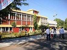
Maharani Laxmi Bai Medical college Hospital Jhansi, established in 1968, is named after the "Jhansi ki Rani" Maha Rani Laxmi Bai. The college admits 100 students each year for medical course and nearly 54 post-graduate students in various specialties.
- Maharani Laxmi Bai Medical College[16]
- Bundelkhand Govt. Ayurvedic College & Hospital
- Smt. Vidyawati Group of Institutions, Jhansi
In October 2009, the Union health ministry gave approvals for setting up an institute equivalent to AIIMS, the first in Bundelkhand region and developing central agriculture university.[17]
- Bundelkhand Institute of Engineering & Technology
- Institute of Engineering and Technology, Bundelkhand University.
- College of Science & Engineering, Jhansi
- Government Polytechnic Jhansi[18]

Research institutes
- ICAR-Indian Grassland & Fodder Research Institute (IGFRI)
- ICAR-Central Agro-Forestry Research Institute (CAFRI)
Schools
- Delhi Public School, Jhansi (DPS Jhansi) - CBSE[19]
- Rani Lakshmibai Public School, Jhansi Cantt
- Army Public School, Jhansi
- Bhani Devi Goyal Saraswati Vidhya Mandir Inter College
- Christ the King College
- Blue Bells public school
- Mount Litera Zee School Jhansi
- St Mark's College
- Margaret Leask Memorial English School, Jhansi
- St. Francis College, Jhansi
- Cathedral College, Jhansi
- Sun International School
- RNS World School
- Jai Academy
- Blue Bells public school
- Hansraj Modern Public School
- Sheerwood College
- Modern Public School
- Don Bosco
- Jacob High School
- St. Stephen's Global School
- Saint Umar Inter College
- Gyan Sthali Public School
- Maharaja Agarsen Sarsawati Vidya Mandir Inter College Shivpuri Road Jhansi
- Bipin Bihari Degree College Jhansi
- Bipin Bihari Inter College Jhansi
Transport
The city is well connected to other parts of India by railways and major highways.
Railways
Jhansi Junction has its own Division of the Indian North Central Railways. It is well connected by train services to all parts of the country, including four metropolitan cities. There are direct trains to Mumbai, Delhi, Hyderabad, Kolkata, Chennai, Bangalore, Guwahati, Visakhapatnam, Nagpur, Agra, Gwalior, Trivandrum, Indore, Ahmedabad, Udaipur, Pune, Jammu and Kashmir, Jaipur, Lucknow, Bhopal, Mahoba, Khajuraho, Gaya, Jalgaon, Bhusaval, Jabalpur, Kanpur, Allahabad, Gorakhpur, Bandra and other major towns. A list of all train services passing through Jhansi Junction can be found here.[20]
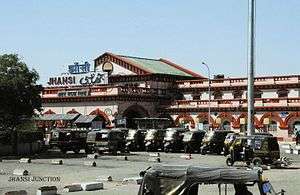
Jhansi Junction is a major railway junction of Indian Railways: a major intercity hub and a technical stoppage for many superfast trains in India. Jhansi has its own division in the North Central Railway zone of Indian Railways. It lies on the main Delhi-Chennai and Delhi-Mumbai lines. The station code is JHS.
History
The railway station was built by the British in the late 1880s. After a long survey of three places the current site was selected for the station. The station has a massive fort-like building painted in maroon and off white.
The station had three platforms in the beginning. Platform One is 2,525 feet (770 m) long making it the seventh longest in the world so could easily handle two trains at a time. Platforms two and three are also long enoungh to do this. The first Shatabdi Express of India started between New Delhi and Jhansi. Earlier Jhansi used to be a part of Central railways zone headquartered at Mumbai but now comes under NCR headquartered at Allahabad.

Connectivity
Jhansi Junction is linked with many industrial and important cities of India by direct trains like Gwalior, New Delhi, Guwahati, Kanpur, Lucknow, Bhopal, Chennai, Hyderabad, Mumbai, Bangalore, Kolkata, Jammu and Kashmir, Agra, Bhubaneshwar, and Ahmedabad.
Jhansi Junction is served by four broad gauge routes:
- Jhansi - Agra - New Delhi
- Jhansi - Kanpur Central - Lucknow
- Jhansi - Bhopal - Mumbai
- Jhansi - Manikpur - Allahabad
- Jhansi - Shivpuri - Sawai Madhopur (proposed)
Jhansi is an important destination for tourists intending to go to Khajuraho (a UNESCO World Heritage Site) and to Orchha.
Trains originating from Jhansi
- 12049/12050 Jhansi Hazrat Nizamuddin (Delhi) Gatimaan Express
- 12279/12280 Jhansi Hazrat Nizamuddin (Delhi) Taj Express
- 11109/11110 Jhansi Lucknow Junction Intercity Express
- 11103/11104 Jhansi Bandra Terminus (Mumbai) Express (via Gwalior, Ujjain, Ratlam, Surat)
- 11105/11106 Jhansi Kolkata Pratham Swatrantata Sangram Express (via Kanpur, Patna)
- 11801/11802 Jhansi Etawah Express
- 21125/21126 Jhansi Gwalior Indore Express
- 51815/51816 Jhansi Agra Fort Passenger
- 51831/51832 Jhansi Agra Cantt Passenger
- 51803/51804 Jhansi Kanpur Central Passenger
- 54157/54158 Jhansi Kanpur Central Passenger
- 51813/51814 Jhansi Lucknow Charbagh Passenger
- 51807/51808 Jhansi Banda Passenger
- 54159/54160 Jhansi Banda Passenger
- 51805/51806 Jhansi Manikpur Passenger
- 51819/51820 Jhansi Allahabad Jn Passenger
- 51817/51818 Jhansi Tikamgarh Passenger
- 51821/51822 Jhansi Khajuraho Passenger
- 51811/51812 Jhansi Bina Passenger
- 51827/51828 Jhansi Itarsi Nagpur Passenger
- several other passengers and shuttles trains connecting Lucknow, Kanpur, Agra Cantt, Allahabad, Manikpur, Banda Jn, Khajuraho, Tikamgarh, Bhopal, Bina and Itarsi
Facilities
Jhansi Junction has seven platforms and four broad over-bridges. Due to heavy usage, two new platforms are planned, increasing the total to 11. Five pairs of the Rajdhani Express as well as the Bhopal — New Delhi Shatabdi Express pass through Jhansi.Three pairs of Duronto Express also have their technical stoppages at Jhansi. All state Sampark Krantis passing through Jhansi have official stops at Jhansi. In all more than 150 trains stop at Jhansi Junction everyday.
There are tourist information offices of both the Madhya Pradesh and Uttar Pradesh governments.
Road transport
Jhansi is located at the junction of these National Highways: National Highway 27 (India) from Gujarat to Assam; National Highway 44 (India) from Jammu to Kanyakumari; and National Highway 39 (India). Thus, Jhansi commands a strategic position in the roadways network as highways in five different directions diverge from it.
The towns and major cities connected to it are Datia, Gwalior, Lalitpur, Agra, New Delhi, Bhopal, Allahabad, Kanpur, Orchha, Shivpuri, Tikamgarh, Unnao Balaji, and Sagar.
The north-south and east-west corridors pass and cross each other only in Jhansi and the city is also well connected to Kanpur, Lucknow and Madhya Pradesh by road. The four lane national highway is at the last stage of its completion, giving a boom in infrastructure and other sectors in Jhansi and nearby areas;
Air transport
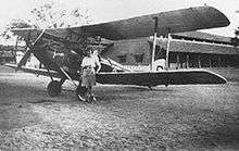
Jhansi Airport is a military aviation base built in the British era used by the Indian army and political visitors. Though there are provisions for private aircraft to land, there are no civil aviation operations. There had been a demand to make it operational for commercial purposes in the 1990s and again in the 2000s. The Uttar Pradesh government announced the construction of an all new civil aviation base to support tourism in Bundelkhand in April 2011.[21] The Indian army maintains an objection to extension of the military aviation. So, the government has examined three different places other than army aviation base for the airport in Jhansi. Gwalior Airport is the nearest airport from Jhansi.
Major markets
- Manik Chowk [Old City) - the biggest and most important market of Jhansi. Combination of three major markets the Sarafa Bazaar, Bada Bazaar, and Purani Najhai. Ancient buildings of different styles of architecture (such as Chandeli, British, Maratha, Mughal, and Rajputi) can be viewed.
- Sadar Bazar - one of the oldest markets of Jhansi City and now is the most expensive one and well known for its branded clothing stores, bakeries, and this place was used by the army cantonment and local population for business by selling goods for statesmen and other rich people.
- Sipri Bazaar- one of the old markets of the City known for its vegetable market and cheap clothing goods and accessories; situated on Shivpuri Road (known to be Shivpuri Bazaar which later changed to Sipri Bazaar)
- Loha Mandi- market known for steel and iron goods as well as good building materials including floor stone and marble.
- Elite Circle - in the City Centre of Jhansi which is a junction point of five radial roads with huge number of hotels and shops
- Jhokan Bagh - known for its furnished goods and furniture at reasonable prizes; however, its roads are irregular and not well maintained.
Armed forces
The Jhansi Cantonment was the site of the accommodation for British civil and military personnel in the period of British rule in India.
Media
Amar Ujala, Dainik Jagran, Patrika,[22] and Dainik Bhaskar are some of the newspapers with online news services.
Newspapers
Many national and local newspapers are published in Jhansi in Hindi, Urdu and English:
| Newspaper | Language | Notes |
|---|---|---|
| Amar Ujala | Hindi | |
| Dainik Jagran | Hindi | |
| Daily Aziz E Hindustan | Urdu | |
| Dainik Royal Mail | Hindi | |
| Dainik Vishwa Pariwar | Hindi | |
| Hindustan | Hindi | |
| Jan Jan Jagran | Hindi | |
| Jan Seva Mail | Hindi | |
| Raftaar | Hindi | |
| Patrika[23] | Hindi | |
| Swadesh | Hindi |
Radio
Jhansi has three radio stations: Radio Mirchi 98.3 FM, 92.7 BIG FM, 103.0 AIR FM and 91.1 Red FM.
Cinema
Jhansi currently has three cinema halls which are operating; the rest are under construction.
- Elite Cinema
- Khilona Cinema
- Natraj Cinema
Sport
Sports stadiums in Jhansi are Dhyanchand Stadium, Railway Stadium, and LVM Sports Place.
Notable people associated with Jhansi
- Edward Angelo (born 1870), Australian politician
- Alexander Archdale, English actor in theatre and film
- Chandra Shekhar Azad, Indian freedom fighter
- Vinod Kumar Bansal, Bansal classes, kota
- Michael Bates, English actor; Last of the Summer Wine and It Ain't Half Hot Mum
- Major Dhyan Chand, Indian Army officer and hockey player for the national team of India
- Maithilisharan Gupt, modern Hindi poet
- Hesketh Hesketh-Prichard, explorer, adventurer, big-game hunter and marksman who made a significant contribution to sniping practice within the British Army in the First World War
- Piyush Jha, film director and screenwriter and novelist of Indian origin
- Abdul Karim (the Munshi), an Indian attendant of Queen Victoria who served her during the final 15 years of her reign, gaining her maternal affection over that time.
- Subodh Khandekar, Olympian hockey player
- Tushar Khandekar, player on Indian national hockey team
- Ashok Kumar, former player on Indian national hockey team
- Rani Lakshmibai, great queen consort of Maharaja Gangadhar Rao; queen 1853-58
- Pankaj Mishra, Indian essayist and novelist
- Joy Mukherjee, Indian actor and director
- Ram Mukherjee, Indian director
- Sashadhar Mukherjee, producer of Hindi films
- Subodh Mukherjee, director, producer, writer of Hindi cinema; hits include Paying Guest, Munimji, Love Marriage (parts were shot at Jhansi), and Junglee
- Randeep Rai, Indian television and film actor
- Maharaja Gangadhar Rao, Raja of Jhansi State, 1838–53
- Dr Saumitra Rawat, surgeon, Chairman and Head, Surgical Gastroenterology and Liver Transplant, Sir Ganga Ram Hospital, New Delhi; 2015 Padma Shri
- Amit Singhal, senior vice-president at Google
Jhansi in literature
Two novels by John Masters are set in the fictional town of Bhowani. According to the author, writing in the glossary to the earlier novel, Nightrunners of Bengal, Bhowani is an "imaginary town. To get a geographical bearing on the story it should be imagined to be about where Jhansi really is - 25.27 N., 78.33 E."[24] Nightrunners of Bengal is set during the Indian Rebellion of 1857 at "Bhowani" (the title alludes to the mysterious distribution of "chapatis" to village headmen which preceded the revolt). Bhowani Junction is set in 1946/47 the eve of independence. In each novel the main character is a British army officer named Colonel Rodney Savage, one of a succession of such men from the same family.
Christina Rossetti wrote a short poem about the fate of the Skene family at Jhansi during the Indian Mutiny. It is entitled "In the Round Tower at Jhansi - 8 June 1857". It was published in 1862 in the same volume as her more celebrated poem "Goblin Market". Some time afterwards, Rossetti discovered that she had been misinformed about the husband and wife's suicide pact in the face of a murderous and implacable enemy ('The swarming howling wretches below' the tower walls) which is the poem's subject, but did not delete it from later editions.
Jhansi also appears as the backdrop for a portion of the George MacDonald Fraser novel Flashman in the Great Game, set just before and during the Indian Rebellion of 1857.
See also
References
- 1 2 3 "Data". www.census2011.co.in. 2011. Hindu 1823930 91.26% Muslim 147842 7.4% Christianity 7050 .35% Sikh 4951 .25% Baudh 1203 .06% Jain 7328 .37% Other 311 .02% Saprate 988 .30% ttitle=Jhansi City Census 2011 data epublisher=Census 2011 - Census of India}}
- ↑ "Uttar Pradesh plans to develop Jhansi airport". igovernment.in. 4 January 2011. Archived from the original on 21 March 2012. Retrieved 3 September 2015.
- ↑ "Centre unveils list of 98 smart cities; UP, TN strike it rich". The Hindu. 28 August 2015.
- ↑ "Smart City Jhansi". Mygov.in. Retrieved 2016-06-24.
- ↑ "स्मार्ट सिटी की परीक्षा में फेल हुए यूपी के 12 शहर". Amar Ujala. 30 January 2016.
- ↑ "Imperial Gazetteer of India, Volume 14, page 148". dsal.uchicago.edu. Digital South Asia Library. Retrieved 20 July 2017.
- ↑ "INDIA : urban population". www.populstat.info. Retrieved 20 July 2017.
- ↑ "Jhansi (Jhansi, Uttar Pradesh, India) - Population Statistics and Location in Maps and Charts". www.citypopulation.de. Retrieved 20 July 2017.
- 1 2 3 "Jhansi City Census 2011 data". 2011 Census of India.
- ↑ "Census of India 2001: Data from the 2001 Census, including cities, villages and towns (Provisional)". Census Commission of India. Archived from the original on 16 June 2004. Retrieved 20 February 2013.
- ↑ "Jhansi, India Page". fallingrain.com. Retrieved 3 September 2012.
- ↑ The Macmillan Encyclopedia; rev. ed. London: Macmillan, 1983; p. 647
- ↑ Moore, W. G. (1971) The Penguin Encyclopedia of Places. Harmondsworth: Penguin; p. 371
- ↑ "Jhansi Climatological Table Period: 1971–2000". India Meteorological Department. Retrieved April 15, 2015.
- ↑ "Ever recorded Maximum and minimum temperatures up to 2010" (PDF). India Meteorological Department. Archived from the original (PDF) on 21 May 2013. Retrieved April 15, 2015.
- ↑ "Maharani Laxmibai Medical College Jhansi". Mlbmcj.in. Retrieved 2016-06-24.
- ↑ "Centre clears an 'AIIMS' for Bundelkhand". Archive.indianexpress.com. Retrieved 23 August 2015.
- ↑ "Archived copy". Archived from the original on 9 January 2014. Retrieved 30 December 2013.
- ↑ Delhi Public School, Jhansi (DPS Jhansi) - CBSE
- ↑ "JHS/Jhansi Junction (7 PFs) Railway Station - Train Departure Timings". India Rail Info. Retrieved 2016-06-24.
- ↑ Manjul, Tarannum (1 April 2011). "New airport at Jhansi to boost tourism". indianexpress. Retrieved 3 September 2012.
- ↑ "Jhansi Hindi News". Patrika. Retrieved 13 December 2017.
- ↑ https://www.patrika.com/jhansi-news/
- ↑ Masters, John. Nightrunners of Bengal. (London and New York, 1951). Glossary.
External links
| Wikimedia Commons has media related to Jhansi. |

- Official website