List of Indian states and territories by highest point
This is the alphabetical list of the highest points of the Indian states and territories.
States
Union Territories
| State | Peak | Range/Region | Height (m) | Height (ft) | Coordinates | Source |
|---|---|---|---|---|---|---|
| Andaman & Nicobar Islands | Saddle Peak | North Andaman Island | 732 | 2,402 | 13°09′31″N 93°00′21″E / 13.1586°N 93.0058°E | [35] |
| Chandigarh | Unnamed point | Capital Area | 383 | 1,257 | ||
| Dadra and Nagar Haveli | Unnamed point | Khanvel | 424 | 1391 | ||
| Daman and Diu | Unnamed point | Diu | 30 | 98 | ||
| Delhi | Unnamed point | Tughlaqabad | 319 | 1,047 | ||
| Lakshadweep | Unnamed point | Agatti Island | 15 | 49 | ||
| Puducherry | Les Montagnes Rouges | Red Hills | 30 | 98 |
Gallery
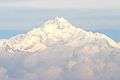 Kangchenjunga (8,586 m)
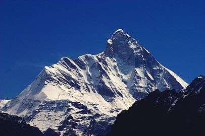 Nanda Devi (7,816 m)
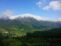 Anamudi (2,695 m)
 Kalsubai (1,646 m) rc
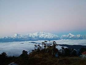 Sandakphu (3,636 m)
References
- ↑ The Geography of India: Sacred and Historic Places
- ↑ The britannica Quiqmaster
- ↑ "Assam Hills". Birdlife International.
- ↑ Fort Someshwar, West Champaran district, Bihar
- ↑ Bailadila Hills, Dantewada district, Chhattisgarh
- ↑ National Mineral Development Corporation, Dantewada district, Chhattisgarh
- ↑ छत्तीसगढ़ के सर्वोच्च शिखर गौरलाटा पर 5 वर्ष की एडविना कांत
- ↑ "The tiger in the tale". The Times of India. 2011-12-12.
- ↑ Background Information about the State of Gujarat, dgfasli.nic.in
- ↑ Bijender K Punia (1994). Tourism Management: Problems and Prospects. APH Publishing. pp. 21–. ISBN 978-81-7024-643-5.
- ↑ "Famous peaks in Himachal Pradesh".
- ↑ "Saltoro Kangri, Pakistan/India". Peakbagger.com.
- ↑ "Top 10 highest Himalaya mountain peaks in India".
- ↑ "Top 10 highest peaks of India".
- ↑ "Parasnath". Archived from the original on 2005-10-18.
- ↑ Ganesh Prabhu (2014-03-19). "Udupi-Chikmagalur: A constituency that's beset by problems". The Hindu.
- ↑ "Anai Mudi". Peakbagger.com.
- ↑ M.S. Kohli (2002). Mountains of India: Tourism, Adventure and Pilgrimage. Indus Publishing. p. 39. ISBN 978-81-7387-135-1.
- ↑ "Kalsubai".
- ↑ "Hills Of Manipur". Archived from the original on 2013-03-23.
- ↑ "Manipur Tourism District:Senapati".
- ↑ The Rough Guide to India. Rough Guides. 1 October 2013. pp. 963–. ISBN 978-1-4093-4267-0.
- ↑ "Phawngpui, Mizoram".
- ↑ "Saramati". Peakbagger.com.
- ↑ "Deomali Peak in Koraput".
- ↑ "GAZETTEER RUPNAGAR".
- ↑ "Guru Shikhar, Mount Abu". Archived from the original on 2009-04-10.
- ↑ "Kangchenjunga - Peakware".
- ↑ "A Beautiful Green Hills". Archived from the original on 2007-09-29.
- ↑ "Wikimapia - Doli Gutta (965m) - Telangana Chhattisgarh border. Possibly highest point in Telangana".
- ↑ "Peakbagger - Betalongchhip, India".
- ↑ Mahesh Chandra Porwal (1997). Remote Sensing Analysis of Environmental Resources for Planning and Development. APH Publishing. p. 31. ISBN 978-81-7024-808-8.
The northwestern portion has the greatest elevation having highest point at Amsot peak (957 m)
- ↑ "Nanda Devi - Peakware".
- ↑ "Sandakphu". Archived from the original on 2008-12-25.
- ↑ "Saddle Peak -- Britannica".
This article is issued from
Wikipedia.
The text is licensed under Creative Commons - Attribution - Sharealike.
Additional terms may apply for the media files.