Bhind district
| Bhind district | |
|---|---|
| District of Madhya Pradesh | |
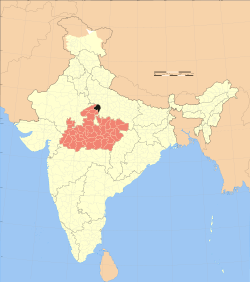 Location of Bhind district in Madhya Pradesh | |
| Country | India |
| State | Madhya Pradesh |
| Administrative division | Morena |
| Headquarters | Bhind |
| Tehsils | 8 |
| Government | |
| • Lok Sabha constituencies | Bhind |
| Area | |
| • Total | 4,459 km2 (1,722 sq mi) |
| Population (2011) | |
| • Total | 1,703,564 |
| • Density | 380/km2 (990/sq mi) |
| Demographics | |
| • Literacy | 75.3 per cent |
| • Sex ratio | 838 |
| Major highways | NH92 |
| Website | Official website |
Bhind District is a district of Madhya Pradesh state in central India of Chambal division. The town of Bhind is the district headquarters. Bhind District is situated in Chambal region in the northwest of the state. The geographical coordinates of the district are Latitude 26°36' N and Longitude 78°46' E. It is bounded by Agra, Etawah, Jalaun and Jhansi districts of Uttar Pradesh state to the north and the east, and the Madhya Pradesh districts of Datia to the south, Gwalior to the southwest, and Morena to the west. The geography of the district is characterized by uneven ravines, plain fertile fields and scanty forests. The total area of the district is 4,459 km².
The soil of Bhind is very fertile and is drained by the Chambal, Kali Sind, Kunwari or Kwari, Pahuj and Baisali rivers and by an extensive canal system. Formerly there were four tehsils, Bhind, Mehgaon, Gohad and Lahar, but at present there are eight tehsils: Bhind, Ater, Gormi, Mehgaon, Gohad, Lahar, Mihona, and Raun. The district is part of the Chambal Division. Bhagirath Prasad is an M.P. from Bhind. However Bhind is a predominantly kachwah(Rajawat) and Bhadouria Rajputs, dominated region.lodhi, Brahmin, Bhumihaar, Dhobi are also present in sizable number.[1]
History
The district is named after the mythological Hindu saint Vibhandak Rishi, also called Bhindi Rishi. During Vedic period this region was ruled by Yadu, the son of King Yayati. Historically during Mahabharat Era, this region was under the reign of Chedi King Shishupal. During Mahajanapada period Chedi had a prominent position.In 6th century Suraj sen kachwaha of Kachwaha dynasty built the Gwalior Fort and establish rule in gwalior.in 10th century when duleh ray of gwalior moved his rule to Jaipur State his younger brother bisaldev moved to bhind and defeated Mevatis of Datia district.The district was under the rule of kushan king Kanishk during 1 a.d to 3.ad and under Gurjar rule between 700 a.d to 1250 a.d .
The State of Madhya Bharat was formally inaugurated by Jawaharlal Nehru, the then Prime Minister of India, on 28 May 1948 at Gwalior. Scindia and Holkar were sworn in as the Rajpramukh and Up-Rajpramukh, respectively. It was decided to divide the Union into six districts and Bhind was one among them. As a result of reorganization of the states Madhya Bharat was added to Madhya Pradesh state on 1 November 1956.
Mythology and history
- Ganesh mandir is an ancient Ganesh temple built at the ghats of Gauri pond.
- Dandraua Hanuman Mandir is an ancient Hanuman mandir. Hanuman ji is best known as Dr . Hanuman.
- Vankhandeshwar mandir is an ancient Shivalaya built by Prithviraj Chauhan.
- Akoda is the place where Kherapati Hanuman Mandir(Panjay Sarkar). This Town situated 10 km from Bhind.
- Nunhata village is a centre of kachwah(Rajawat) Rajputs located near river besli.
- Naarada (Lahar) is the place where mythological saint Maharshi Narada prayed.
- Maharshi Bhindee Bhind was the ground of Maharshi Bhindee's dacoit life.
- Pandari is a village in Bhind Tehsil, where Pandavas took refuge during Agyatvas period of their banishment. Pandari is originated from the word Pandav Vati.
- Virendra Nagar is the colony of Bhind famous for The Gentlemen like Mukesh Bohare,Arvind Bohare,Dileep Bohare,Rishabh Bohare and other Bohares.
- Lavan is a village in Bhind Tehsil, birthplace of "Vishnudas", who was the predecessor to Tulsidas for Ram Katha (Story of Rama), he was also named "Sahajnath".
- Bhawani Gauri Sarover is a pond built at Bhind town by Pritivi Raj Chauhan.
- Machhand is a village in Mihona Tehsil, noted as the place of penance of Machhendranath, the Guru of Guru Gorakhnath.
- Bijpuri is a village in Bhind Tehsil, known for the Samadhi of Sage Gwalav, after which Gopachal fort came to be known as Gwalior Fort.
- Boreshwar is a temple in Ater Tehsil at Dulhagan village and contains an ancient Shiva temple.
- Sapad-Sammana are villages on the banks of river Chambal where Mythological sage Shringi Rishi's Ashram was situated. Shringi Rishi performed 'Putreshti Yagya' for king Dasharath.
- Mehoni village was the capital of Bundelkhand during 10th-13th century known as Veerghar ruled by King Veerpal Bundela.
- Chilonga Village is situated on the bank of Chambal River, and is notable for the residential town of Bhadauria (Clan Of Ancient Ruler Rajput Of Bhind and other area of Chambal) and for Goddess Sati Mata Temple. Sant Avdhoot Ashram (Gaushala)
- Pidora is a small village near Bhind notable for the contributions of Shri Aasharam Chaudhary (Motebaba) and Shri Rajaram Samadhiya to a school, hospital, post office and other developments in the village.
- Mehda village situated at bank of Kali Sindh. In village Sati a Gau Mata (Cow). Its temple at bank of Kali Sindh
- Ratan gard
- Barhad is the name derived from many Banyan tree in this place. There is also a Vishnu Mandir which is more than 500 years old.
- Lord Parashurama was born Jamdara Tehsil Gohad.
- Bhatmaspura village has an ancient temple of iksha purna hanuman ji and shivji, gadaiya bali kamna purna durga. There are two ponds near the temple.
- Sukand village was once state of nekadi clan of gurjar whou fought against Muslim alongside king of Bhadauria and got the title of Choudhary by thakur pancham singh nekadi and salute of two cannons
- Manhad was once the seat of gurjar doyla Chauhan clan who fought with the Muslims along with side of the bhadawar king and got title of Choudhary and five villages in jagir consisting kanathar, itayana, kathrol, saura and daundari
- Baransou is the village of gurjar, Nagar (Langai) clan who fought against Muslims, alongside of Bhadauria king and got Choudhary title.
- Jithasou is the village of gurjar, who fought against Muslims, alongside of Bhadauria king and got Choudhary title
Ravines
This region is identified by rest of India by its extensive ravines. The ravines created by gully erosion, are heavily under soil loss. The Government of Madhya Pradesh has tried to check this soil erosion and expansion of ravines by the means of watershed development and by aerial-seeding for plants like Prosopis, Acacia, and Jatropha in the ravines.and mp govt. are trying to increase the education system of bhind district
Demographics
According to the 2011 census Bhind District had a population of 1,703,562,[2] roughly equal to the nation of [[The Gambia]][3] or the US state of Nebraska.[4] This gives it a ranking of 286th in India (out of a total of 640).[2] The district has a population density of 382 inhabitants per square kilometre (990/sq mi).[2] Its population growth rate over the decade 2001-2011 was 19.25%.[2] Bhind has a sex ratio of 838 females for every 1000 males,[2] and a literacy rate of 76.59%.[2]
Tourist attractions
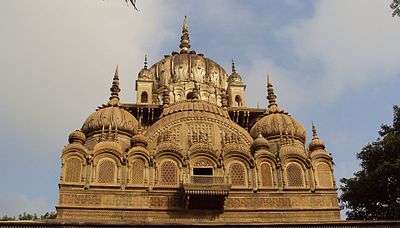
Chhatri of Malhar Rao Holkar, Alampur
Dhangar Kshatriya(Baghel) clan Ruler Maharani Ahilya Bai Holkar built the chhatri of Maharaja Malhar Rao Holkar at Alampur in Bhind district in 1766 A.D. It is marked by carvings. It is built on the pattern of the chhatris of Holkar rulers at Indore.
Shri Rawatpura Dham
The temple of Hindu Lord Hanuman is situated at Lahar tehsil of Bhind. This place is known as Rawatpura Dham and is under in Lahar tehsil.
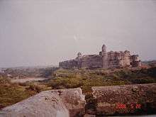
Fort of Ater
The Fort of Ater is located near Ater town, 35 km from Bhind and 40 km from Porsa. It was built by the Bhadauria kings Badan Singh, Maha Singh and Bakhat Singh in 1664-1668. The fort is situated on the banks of the Chambal River. There is a Kali temple situated at Maghera village in Ater tehsil, 15 km from Ater fort was built by Puruvanshi samaj in 1681.
Jain temples
The temple of Lord Mahavira is situated at Barason in Mehgaon tehsil. In Jain tradition, it is among the Atishaya kshetra, i.e. places where lord Mahavira visited during his journey after getting Kaivalya (Ultimate Realization) and miraculous events took place. It is situated 14 km from Bhind town. Other Atishaya kshetra are Jain temple of Lord Neminath at Pavai near Bhind town and Lord Parshvanatha at Barahi, which is 20 km from Bhind at the Bhind-Etawah district border on the bank of the Chambal. An ancient holy place called "Digambar jain Parasnath Jinalaya" is situated in the village of Simar Biragma, about 20 km from Bhind and approximately 6 km from Atishaya kshetra Barason. There are approximately 60 Jain temples in Bhind town itself.
Mata Renuka Temple
An ancient temple is situated at Jamdara village in Gohad tehsil, 45 km from Bhind, which was thought to be built by the mythological sage Parashurama.
Narad Dev Temple
An ancient temple of God Narad Dev is situated on the banks of the Kali Sindh. It can be reached by Lahaar Madori road, and is around 1 km from Madori.
National Chambal (Gharial) Wildlife Sanctuary
National Chambal (Gharial) Wildlife Sanctuary is situated on the Chambal River, and is inhabited by crocodiles, ghariyals, Ganges Dolphins, and migratory birds. A boat cruise is organised by local forest officials. The sanctuary is 22 kilometres (14 mi) from Bhind town.
Gohad Fort
This fort at Gohad was built by the Jat king Maha Singh in the 16th century. Government offices are currently situated on its premises.
Sun Temple
The Sun temple, also known as Balaji Temple, is situated 42 kilometres (26 mi) from Bhind at Balaji near Mihona Tehsil.
Ancient Dandraua Temple
This is a temple to the Hindu God Hanuman, believed to possess curing powers. Worshipers go to the temple every Tuesday and Saturday. Another Panchmukhi Hanuman mandir in Heerapura 10 km from Lahar. Dandraua Dham [website] http://www.dandrauasarkar.com/
Jamana Wale Hanuman Ji
This is a temple (Bajrang Bali) in Rekha nagar behind new collectorate. \/-\
Vankhandeshwar Temple
Vankhandeshwar temple of lord Shiva is located near the bank of Gauri sarovar, a beautiful lake. It is said that this temple is founded by Prithviraj chauhan (Prithviraj).
Malanpur
Malanpur is the modern industrial area in Bhind District near Gwalior in Gohad tehsil, 65 km from Bhind town. Its industries include modern automobiles, bicycles, soaps and detergents, electronics, pharmaceuticals and food and dairy products
Akoda A town 10 km east of district bhind. Here is nagarpanchayat having population approx 20,000. This is a historical place. Bhadoria rajput ruled here and had their kings here.
Main attractions are old garhi and hunaman mandir.
References
- ↑ http://planningcommission.nic.in/reports/sereport/ser/bndel/stdy_bndel.pdf
- 1 2 3 4 5 6 "District Census 2011". Census2011.co.in. 2011. Retrieved 2011-09-30.
- ↑ US Directorate of Intelligence. "Country Comparison:Population". Retrieved 2011-10-01.
Gambia, The 1,797,860 July 2011 est.
- ↑ "2010 Resident Population Data". U. S. Census Bureau. Archived from the original on 2013-10-19. Retrieved 2011-09-30.
Nebraska 1,826,341
External links
| Wikimedia Commons has media related to Bhind district. |
Places adjacent to Bhind district | |
|---|---|