Jammu
| Jammu City of Temples | |
|---|---|
| City | |
  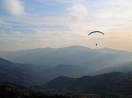 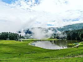 clockwise from top: Amar Mahal Palace, Vaishno Devi Temple, Paragliding at Patnitop and Sanasar Lake | |
 Jammu  Jammu | |
| Coordinates: 32°44′N 74°52′E / 32.73°N 74.87°ECoordinates: 32°44′N 74°52′E / 32.73°N 74.87°E | |
| Country |
|
| State |
|
| District | Jammu |
| Government | |
| • Type | Municipal Corporation |
| • Body | Jammu Municipal Corporation and Jammu Development Authority |
| Area | |
| • City | 167 km2 (64 sq mi) |
| Elevation[1] | 350 m (1,150 ft) |
| Population (2011) | |
| • City | 502,197 |
| • Rank | 92nd |
| • Metro | 657,314 |
| Languages | |
| • Official | Urdu, English |
| • Spoken | Dogri, Punjabi, Hindi |
| Time zone | UTC+5:30 (IST) |
| PIN | 180001[2] |
| Vehicle registration | JK-02 |
| Sex ratio | 867 ♀/ 1000 ♂ |
| Literacy | 90.14% |
| Distance from Delhi | 575 kilometres (357 mi) NW |
| Distance from Mumbai | 1,971 kilometres (1,225 mi) NE (land) |
| Climate | Cfa (Köppen) |
| Precipitation | 710 millimetres (28 in) |
| Avg. summer temperature | 29.6 °C (85.3 °F) |
| Avg. winter temperature | 17.7 °C (63.9 °F) |
| Website |
jammu |
Jammu ![]()
Etymology
According to local tradition, Jammu is named of its founder, Raja Jambulochan, who is believed to have ruled the area in the 9th century.[4] The local tradition in fact holds the city to be 3000 years old but this is not supported by historians.[5]
Geography
Jammu is located at 32°44′N 74°52′E / 32.73°N 74.87°E.[6] It has an average elevation of 350 m (1,150 ft). Jammu city lies at uneven ridges of low heights at the Shivalik hills. It is surrounded by Shivalik range to the north, east and southeast while the Trikuta Range surrounds it in the north-west. It is approximately 600 kilometres (370 mi) from the national capital, New Delhi.
The city spreads around the Tawi river with the old city overlooking it from the north (right bank) while the new neighbourhoods spread around the southern side (left bank) of river. There are five bridges on the river. The city is built on a series of ridges.
History
Jammu has historically been the capital of Jammu Province and the winter capital of the princely state of Jammu and Kashmir state (1846–1952).
The early history of Jammu is relatively unknown. According to Tarikh-i-Azmi, Jammu came into existence around 900 CE. The state of Durgara (modern forms "Duggar" and "Dogra)") is also attested from around this time.[7][8] The capital of the Durgara state at that time is believed to have been Vallapura (identified with modern Billawar). Its rulers are repeatedly mentioned in Kalhana's Rajatarangini.[9] Babbapura (modern Babor) is another state mentioned in Rajatarangini, some of whose rulers occur in the Vamshavali (family chronicles) of later Jammu rulers. These rulers are believed to have enjoyed almost independent status and allied themselves with the Sultans of Delhi. Raja Bhim Dev is prominently mentioned in the Delhi chronicles as a supporter of Mubarah Shah (r. 1421–1434).[10]
Jammu is mentioned by name in the chronicles of Timur (r. 1370–1406), who invaded Delhi in 1398 and returned to Samarkand via Jammu. In the Mughal chronicles of Babur in the early 16th century, Jammu is mentioned as a powerful state in the Punjab hills. It is said to have been ruled by Manhas Rajputs. Emperor Akbar brought the hill kingdoms of the region under Mughal suzerainty, but the kings enjoyed considerable political autonomy. In addition to Jammu, other kingdoms of the region such as Kishtwar and Rajauri were also prominently mentioned. It is evident that the Mughal empire treated these hill chiefs as allies and partners in the empire.[11]
After the decline of the Mughal power in the 18th century, the Jammu state under Raja Dhruv Dev of the Jamuwal (Jamwal) family asserted its supremacy among all the Dugar states. Its ascent reached its peak under his successor Raja Ranjit Dev (r. 1728–1780), who was widely respected among the hill states.[12][13] Ranjit Dev promoted religious freedom and security, which attracted a large number of craftsmen and traders to settle in Jammu, contributing to its economic prosperity.[14]
Towards the end of Ranjit Dev's rule, the Sikh clans of Punjab (misls) gained ascendency, and Jammu began to be contested by the Bhangi, Kanhaiya and Sukerchakia misls. Around 1770, the Bhangi misl attacked Jammu and forced Ranjit Dev to become a tributary. Brij Lal Dev, Ranjit Dev's successor, was defeated by the Sukerchakia chief Mahan Singh, who sacked Jammu and plundered it. Thus Jammu lost its supremacy over the surrounding country.[15] In 1808, Jammu itslef was annexed to the Sikh Empire by Maharaja Ranjit Singh, the son of Mahan Singh.[16]
Then came the Dogra dynasty founded by Raja Gulab Singh who eventually became the Maharaja of Jammu and Kashmir. The rulers built great temples, renovated old shrines, built educational institutes and many more. A 43 km long railway line connecting Jammu with Sialkot was laid in 1897[17]
After the partition of India, Jammu continues as the winter capital of the Indian state of Jammu and Kashmir.
Climate
Jammu, like the rest of north-western India, features a humid subtropical climate (Köppen: Cwa),[18] with extreme summer highs reaching 46 °C (115 °F), and temperatures in the winter months occasionally falling below 4 °C (39 °F). June is the hottest month with average highs of 40.6 °C (105.1 °F), while January is the coldest month with average lows reaching 7 °C (45 °F). Average yearly precipitation is about 42 inches (1,100 mm) with the bulk of the rainfall in the months from June to September, although the winters can also be rather wet. In winter dense smog causes much inconvenience and temperature even drops to 2 °C (36 °F). In summer, particularly in May and June, extremely intense sunlight or hot winds can raise the mercury to 46 °C (115 °F). Following the hot season, the monsoon lashes the city with heavy downpours along with thunderstorms: rainfall may total up to 669 mm (26.3 in) in the wettest months.
| Climate data for Jammu (1971–2000) | |||||||||||||
|---|---|---|---|---|---|---|---|---|---|---|---|---|---|
| Month | Jan | Feb | Mar | Apr | May | Jun | Jul | Aug | Sep | Oct | Nov | Dec | Year |
| Record high °C (°F) | 28.0 (82.4) |
31.7 (89.1) |
37.2 (99) |
43.9 (111) |
47.4 (117.3) |
47.2 (117) |
45.0 (113) |
41.7 (107.1) |
38.9 (102) |
37.9 (100.2) |
34.2 (93.6) |
28.1 (82.6) |
47.4 (117.3) |
| Average high °C (°F) | 18.9 (66) |
21.6 (70.9) |
25.6 (78.1) |
32.0 (89.6) |
37.2 (99) |
38.7 (101.7) |
34.0 (93.2) |
33.1 (91.6) |
33.1 (91.6) |
31.2 (88.2) |
26.6 (79.9) |
21.2 (70.2) |
29.6 (85.3) |
| Average low °C (°F) | 7.8 (46) |
9.8 (49.6) |
13.9 (57) |
18.9 (66) |
23.3 (73.9) |
26.0 (78.8) |
25.3 (77.5) |
24.8 (76.6) |
23.1 (73.6) |
18.1 (64.6) |
13.0 (55.4) |
9.0 (48.2) |
17.7 (63.9) |
| Record low °C (°F) | 0.6 (33.1) |
1.1 (34) |
4.4 (39.9) |
8.5 (47.3) |
9.8 (49.6) |
13.8 (56.8) |
14.0 (57.2) |
15.0 (59) |
15.0 (59) |
11.3 (52.3) |
6.1 (43) |
0.9 (33.6) |
0.6 (33.1) |
| Average precipitation mm (inches) | 52.4 (2.063) |
79.0 (3.11) |
74.9 (2.949) |
47.1 (1.854) |
34.8 (1.37) |
87.3 (3.437) |
371.5 (14.626) |
370.2 (14.575) |
140.9 (5.547) |
25.1 (0.988) |
10.1 (0.398) |
38.3 (1.508) |
1,331.6 (52.425) |
| Average rainy days | 3.1 | 4.2 | 4.8 | 3.2 | 3.2 | 5.3 | 12.5 | 13.1 | 6.1 | 1.8 | 1.1 | 2.3 | 60.6 |
| Source: India Meteorological Department (record high and low up to 2010)[19][20] | |||||||||||||
Transport
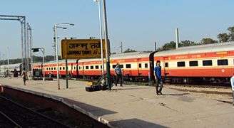
Jammu city has a railway station called Jammu Tawi (station code JAT) that is connected with major cities of India. The old railway link to Sialkot was broken after the Partition of India and Jammu had no rail services until 1971, when the Indian Railways laid the Pathankot - Jammu Tawi Broad Gauge line. The new Jammu Tawi station was opened in October 1972 and is an origination point for Express trains. With the commencement of the Jammu–Baramulla line, all trains to the Kashmir Valley will pass through Jammu Tawi. A part of the Jammu–Baramulla project has been executed and the track has been extended to Katra. Jalandhar - Pathankot - Jammu Tawi section has been doubled and electrified.
.png)
National Highway 1A which passes through Jammu connects it to the Kashmir valley. National Highway 1B connects Jammu with Poonch town. Jammu is just 80 kilometres (50 mi) from Kathua town, while it is 68 kilometres (42 mi) from Udhampur city. Katra is also 49 kilometres (30 mi) away.
Jammu Airport is in the middle of Jammu. It has direct flights to Srinagar, Delhi, Amritsar, Chandigarh, Leh and Mumbai and Bengaluru. Jammu Airport operate daily 30 arrival and departure flights which is Goair, Air India, Spicejet and Indigo running daily flights.
The city has JKSRTC city buses under and mini buses for local transport which run on some defined routes. These mini buses are called "Matadors". Besides this auto-rickshaw and cycle-rickshaw service is also available. Local taxis are also available.
Administration
Jammu city serves as the winter capital of Jammu & Kashmir state from November to April when all the offices move from Srinagar to Jammu. Srinagar serves as the summer capital from May to October.[21] Jammu was a municipal committee during 2001 census of India. With effect from 5 September 2003, it has upgraded status of a municipal corporation.[22]
Economy
Jammu city is the main cultural and economic centre of the administrative division of Jammu. The city has a number of small industries. Jammu has a number of woodgrain mills to cater to the local population. One of the most famous local Basmati Rice is produced in RS Pura area near jammu, which is then processed in rice mills in Jammu. Apart from Rice Mills scattered all around Jammu, industrial estate at Bari Brahamna has a large presence of Industrial units manufacturing a variety of products right from carpets, electronic goods, electric goods etc. The local government gives incentives for new units by foregoing taxes for a few initial years of establishment. Bari Brahamna also has a freight rail link that helps carry the goods manufactured here to other parts of India.
Tourism
Tourism is the largest industry in Jammu as in the rest of the state. It is also a focal point for the pilgrims going to Vaishno Devi and Kashmir valley as it is second last railway terminal in North India. All the routes leading to Kashmir, Poonch, Doda and Laddakh start from Jammu city. So throughout the year the city remains full of people from all the parts of India. Places of interest include old historic palaces like Mubarak Mandi, Purani Mandi, Rani Park, Amar Mahal, Bahu Fort, Raghunath Temple, Ranbireshwar Temple, Karbala, Peer Meetha, Old city and a number of shopping places, fun parks, etc.
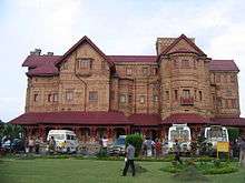
Amar Mahal Palace
The Amar Mahal Palace is a palace in Jammu, in the Indian state of Jammu and Kashmir, India, which has now been converted into a Museum. It was built in the nineteenth century for Raja Amar Singh, a Dogra king by a French architect on the lines of a French Chateau. The palace was donated to the Hari-Tara charitable trust by Dr. Karan Singh for use as a museum. It has many exhibits including a golden throne weighing 120 kg, Pahari miniature and Kangra miniature paintings, a library of 25,000 antique books and many rare art collections. The palace was the last official residence of the Dogra dynasty, and a large collection of portraits of the royal family are also on display in the Museum.
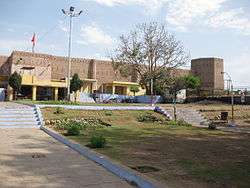
Bahu Fort and Baghe-e-Bahu Garden
Nestled 5 km from the city center, Bahu Fort and Garden lies on the left bank of the Tawi River in the city of Jammu. It was built by Raja Bahulochan more than 3000 years ago. Close to the fort, there is a shrine devoted to the Hindu Goddess Kali. It was renovated in 19th century by the Dogra rulers. There is a terraced garden, called Bagh-e-Bahu.
Raghunath Temple
Amongst the temples in Jammu, the Raghunath Temple[23] takes pride of place being situated right in the heart of the city. This temple is situated at the city centre and was built in 1857. Work on the temple was started by Maharaja Gulab Singh, founder of the Kingdom of Jammu and Kashmir, in 1835 AD and was completed by his son Maharaja Ranbir Singh in 1860 AD. The inner walls of the main temple are covered with gold sheet on three sides. There are many galleries with lakhs of saligrams. The surrounding Temples are dedicated to various Gods and Goddesses connected with the epic Ramayana. This temple consists of seven shrines, each with a tower of its own. It is the largest temple complex in northern India. Though 130 years old, the complex is remarkable for sacred scriptures, one of the richest collections of ancient texts and manuscripts in its library. Its arches, surface and niches are undoubtedly influenced by Mughal architecture while the interiors of the temple are plated with gold. The main sanctuary is dedicated to Lord Vishnu's eighth incarnation and Dogras' patron deity, the Rama. It also houses a Sanskrit Library containing rare Sanskrit manuscripts.
Peer Kho Cave
Alongside the same Tawi river are the Peer Kho Cave temple,[24] the Panchbakhtar temple and the Ranbireshwar temple dedicated to Lord Shiva with their own legends and specific days of worship. Peer Kho cave is located on the bank of river Tawi and it is widely believed that Ramayan character Jamvant (the bear god) meditated in this cave. The Ranbireshwar Temple has twelve Shiva lingams of crystal measuring 12" to 18" and galleries with thousands of saligrams fixed on stone slabs. Located on the Shalimar Road near the New Secretariat, and built by Maharaja Ranbir Singh in 1883 AD. It has one central lingam measuring seven and a half feet height (2.3 m) and twelve Shiva lingams of crystal measuring from 15 cm to 38 cm and galleries with thousands of Shiva lingams fixed on stone slabs.
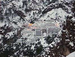
Vaishno Devi
Situated at an altitude of 5,200 feet above sea level, the Holy Cave Shrine of Mata Vaishno Devi or Trikuta Bhagwati has been a beacon of faith and fulfilment to millions of devotees from all over the world. The pilgrimage to the Shrine holds great significance for the pilgrims. The Yatris have to undertake a trek of nearly 12 km from the base camp at Katra. At the culmination of their pilgrimage, the yatries are blessed with the Darshans of the Mother Goddess inside the Sanctum Sanctorum - the Holy Cave. These Darshans are in the shape of three natural rock formations called the Pindies. There are no statues or idols inside the Cave.[25]
A geological study of the Holy Cave has indicated its age to be nearly a million years. As per belief the practice of worshipping Shakti, largely started in the Puranic period and the first mention of the Mother Goddess is in the epic Mahabharat. When the armies of Pandavs and Kaurvas were arrayed in the battlefield of Kurukshetra, Arjun, the chief warrior of Pandavs upon advice of Sri Krishna; meditated upon the Mother Goddess and sought Her blessings for victory. This is when Arjun addresses the Mother Goddess as 'Jambookatak Chityaishu Nityam Sannihitalaye', which means 'you who always dwell in the temple on the slope of the mountain in Jamboo' (probably referring to the present day Jammu). On a mountain, just adjacent to the Trikuta Mountain and overlooking the Holy Cave are five stone structures, which are believed to be the rock symbols of the five Pandavs.[26]
Mubarak Mandi Palace
Mubarak Mandi is a palace in Jammu, India. The palace was the royal residence of the maharaja of Jammu and Kashmir from the Dogra dynasty. It was their main seat till 1925 when Maharaja Hari Singh moved to the Hari Niwas Palace in the northern part of Jammu. The palace is located in the heart of the old walled city of Jammu and overlooks the Tawi river.
Dogra Art Museum
Dogra Art Museum, Jammu previously known as the Dogra Art Gallery is a museum of Dogra cultural heritage housed in the Pink Hall of the Mubarak Mandi complex, Jammu, India. It is a government museum and the biggest in Jammu region, one of the three divisions in the north Indian state of Jammu and Kashmir. The museum is unit of Directorate of Archives, Archaeology and Museums, under the Ministry of Tourism and Culture, Jammu and Kashmir Government. The building was erected in commemoration of the visit of the British Monarch Edward VII when he came to Jammu as the Prince of Wales in 1875. This building housed the Public Library as well as the Museum.
Demographics
As of 2011 census,[28] the population of Jammu city was 502,197. Males constituted 52.7% of the population; females numbered constituted 47.3% of the population. The sex ratio was 898 females per 1,000 males against national average of 940. Jammu had an average literacy rate of 89.66%, much higher than the national average of 74.4%: male literacy was 93.13% and female literacy was 85.82%. 8.47% of the population were under 6 years of age. The urban agglomeration of Jammu had a population of 657,314.[29] Most of Jammu and Kashmir's Hindus live in the Jammu region and are closely related to the Punjabi-speaking peoples in the Punjab state; many speak Dogri,[30] earlier considered a dialect of Punjabi; Dogri is a dialect of Punjabi on the basis of grammar and vocabulary.
_in_1920s.jpg)
| Rank | Language | 1961[31] |
|---|---|---|
| 1 | Dogri | 55% |
| 2 | Punjabi | 22% |
| 3 | Hindi | 11.6% |
| — | Other | 11.4% |
Muslim communities
The Jammu city and the Jammu district had a significant Muslim population prior to the Partition of India, 37 per cent by the 1941 census. During the 1947 Jammu massacres, which preceded and continued during the Pakistan tribal invasion of Kashmir, a large number of Muslims were killed and the rest driven away to Pakistan. The estimates of the number killed vary between 20,000–100,000. The killings were carried out by extremist Hindus and Sikhs, allegedly orchestrated by the Rashtriya Swayamsevak Sangh, and aided and abetted by the State Forces and the Maharaja Hari Singh.[32][33][34] As a result of the violence and migration, by 1961, less than 10 per cent of the population in the Jammu district was Muslim.[35] The displaced Muslims took refuge in the Sialkot District and other parts of Pakistani Punjab. Many prominent Punjab residents in Pakistan, including politician Chaudhry Amir Hussain, economist Mahbub ul Haq, Air Marshal Asghar Khan, journalist Khalid Hasan and singer Malika Pukhraj were from Jammu.[36]
Education
In the 2014–2015 General Budget of India, Arun Jaitley, the Finance Minister of India, proposed an Indian Institute of Technology and an Indian Institute of Management for the division. List of some educational institutions is provided below.
Engineering Colleges in Jammu:-
- Shri Mata Vaishno Devi University, Katra, Kakrial
- Government College of Engineering and Technology, Jammu
- Model Institute of Engineering and Technology, Jammu Kot Bhalwal, Jammu
- Indian Institute of Technology Jammu (to be started)
- Yogananda College of Engineering and Technology, Jammu
Medical Institutions:-
General Degree Courses (colleges):-
Universities:-
Notable people from Jammu
- Nilamber Dev Sharma - Dogri writer & Padma Shri
- Shesh Paul Vaid - IPS Officer
- Ustad Allarakha Qureshi - tabla player
- Malika Pukhraj - singer
- Pandit Shivkumar Sharma - santoor player
- Jitendra Udhampuri - writer
- V. N. Kaul - IAS Officer
- Bana Singh PVC
- Bikram Singh - former Chief of Army Staff (COAS) of the Indian Army.
- Nirmal Chander Vij - 21st Chief of Army Staff of the Indian Army
- Masud Choudhary - IPS Officer
- Ghulam Nabi Azad - Indian Politician
- Jitendra Singh (BJP politician) - Indian Politician
- Chain Singh - Indian Sport Shooter
- Bali Bhagat - Indian Politician
- Nirmal Kumar Singh - Indian Politician
- Ekta Kaul - actor
- K. L. Saigal - singer and actor
- Loveleen Kaur Sasan - actor
- Mohit Raina - actor
- Mukesh Rishi - actor
- Raj Singh Arora - actor
- Shaheer Sheikh - actor
- Sidhant Gupta - actor
- Vidyut Jammwal - actor
- Adarsh Sein Anand - 29th Chief Justice of India
- T. S. Thakur - 43rd Chief Justice of India
- Padma Sachdev - poet, novelist
- Shamma Jain - Ambassador of India
- Mithun Manhas - cricketer
- Shubham Khajuria - cricketer
- Balwant Thakur - theatre director and actor & Padma Shri award winner
Refugees and migration
The annual rate of intra-regional migration is estimated between 29% to 35%. Being comparatively safe from terrorism, Jammu has become a hub of refugees. At present there are about 9-13 lakhs refugees living in and around Jammu in different relief camps. These primarily include Kashmiri Hindus IDP who migrated from Kashmir in 1989, Pakistan administered Kashmir refugees (mainly Hindus), refugees from Reasi, Doda and Kishtwar (both Hindus and Muslims).
Cuisine
Jammu is known for its sund panjeeri, patisa , rajma with rice and Kalari cheese. Dogri food specialties include ambal, khatta meat, kulthein di dal, dal patt, maa da madra, rajma, and auriya. Pickles typical of Jammu are made of kasrod, girgle, mango with saunf, jimikand, tyaoo, seyoo, and potatoes. Auriya is a dish made with potatoes. Jammu cuisine features various chaats, especially gol gappas, kachalu, Chole bhature, gulgule, rajma kulche and dahi palla, among various others.[37]
During weddings it is typical to make kayoor along with sugar.
References
- ↑ Akhtar, Rais. Regional Planning for Health Care System in Jammu and Kashmir. Concept Publishing Company. p. 1. ISBN 9788180696275.
- ↑ Department of Posts, Ministry of Communications, Government of India. "Village/Locality based Pin mapping as on 16th March 2017". data.gov.in. Retrieved 4 October 2018.
- ↑ "Jammu Municipal Corporation (Homepage)". Official website of Jammu Municipal Corporation. Archived from the original on 10 October 2008. Retrieved 4 December 2008.
- ↑ Priya Sethi lays foundation stone of statue of Jambu Lochan, Daily Excelsior, 1 August 2016.
- ↑ Kapur, History of Jammu and Kashmir State 1980, p. 9.
- ↑ "Maps, Weather, and Airports for Jammu, India".
- ↑ Kapur, History of Jammu and Kashmir State 1980, pp. 9–10.
- ↑ Charak & Billwaria, Pahāṛi Styles of Indian Murals 1998, p. 6.
- ↑ Bamzai, Culture and Political History of Kashmir 1994, p. 184.
- ↑ Charak & Billwaria, Pahāṛi Styles of Indian Murals 1998, pp. 6–7.
- ↑ Jigar Mohammad, Raja Ranjit Dev's Inclusive Policies 2010, pp. 40–42.
- ↑ Jeratha, Dogra Legends of Art & Culture 1998, p. 187.
- ↑ Panikkar, Gulab Singh 1930, p. 10.
- ↑ Rai, Hindu Rulers, Muslim Subjects 2004, pp. 94–95.
- ↑ Panikkar, Gulab Singh 1930, p. 10–12.
- ↑ Panikkar, Gulab Singh 1930, p. 15–16.
- ↑ "Imperial Gazetteer2 of India, Volume 14, page 49 -- Imperial Gazetteer of India -- Digital South Asia Library".
- ↑ "Climate: Jammu - Climate graph, Temperature graph, Climate table". Climate-Data.org. Retrieved 29 August 2013.
- ↑ "Jammu Climatological Table Period: 1971–2000". India Meteorological Department. Retrieved April 10, 2015.
- ↑ "Ever recorded Maximum and minimum temperatures up to 2010" (PDF). India Meteorological Department. Archived from the original (PDF) on 21 May 2013. Retrieved April 10, 2015.
- ↑ "Scheme for voting by postal ballot by a person holding any office under the Govt. and verified to be moving along with the headquarters of the Govt. from Kashmir Province to Jammu Province or vice-versa" (PDF). Office of the Chief Electoral Officer, Jammu and Kashmir. p. 1. Retrieved 8 December 2008.
...the State Govt. functions for six months (November to April) in the winter capital Jammu after which it moves to the summer capital Srinagar...
- ↑ "History of Jammu Municipal Corporation". Official website of Jammu Municipal Corporation. Archived from the original on 10 April 2009. Retrieved 4 December 2008.
- ↑ "Department of Tourism, Jammu and Kashmir - Raghunath Temple". www.jktourism.org. Retrieved 2015-09-27.
- ↑ "Department of Tourism, Jammu and Kashmir - Peer Khoh". www.jktourism.org. Retrieved 2015-09-27.
- ↑ "Shri Mata Vaishno Devi".
- ↑ "Shri Mata Vaishno Devi Yatra | Online Registration & Helicopter Booking & much more". www.jammu.com. Retrieved 2015-09-27.
- ↑ "Jammu City Population Census 2011 - Jammu and Kashmir".
- ↑ "Jammu Municipal Corporation Demographics". Census of India. Retrieved 25 April 2017.
- ↑ "Jammu & Kashmir (India): State, Major Agglomerations & Cities – Population Statistics in Maps and Charts". City Population. Retrieved 25 April 2017.
- ↑ "Jammu and Kashmir". Encyclopædia Britannica.
- ↑ Kashmir, India Superintendent of Census Operations, Jammu and; Kamili, M. H. "District Census Handbook, Jammu & Kashmir: Jammu" – via Google Books.
- ↑ Ved Bhasin (17 November 2015). "Jammu 1947". Kashmir Life. Retrieved 4 June 2017.
- ↑ Chattha, Partition and its Aftermath 2009, p. 182, 183.
- ↑ Singh, Amritjit; Iyer, Nalini; Gairola, Rahul K. (2016-06-15). Revisiting India's Partition: New Essays on Memory, Culture, and Politics. Lexington Books. p. 149. ISBN 9781498531054.
- ↑ Luv Puri, Across the Line of Control 2012, p. 30.
- ↑ Luv Puri, Across the Line of Control 2012, pp. 3, 31.
- ↑ "Jammu Pincode". citypincode.in. Retrieved 2014-05-19.
Bibliography
- Bamzai, P. N. K. (1994), Culture and Political History of Kashmir: Ancient Kashmir, M.D. Publications Pvt. Ltd., ISBN 978-81-85880-31-0
- Charak, Sukh Dev Singh; Billawaria, Anita K. (1998), Pahāṛi Styles of Indian Murals, Abhinav Publications, ISBN 978-8-17017-356-4
- Jeratha, Aśoka (1998), Dogra Legends of Art & Culture, Indus Publishing, ISBN 978-81-7387-082-8
- Kapur, Manohar Lal (1980), History of Jammu and Kashmir State: The making of the State, Kashmir History Publications
- Mohammad, Jigar (November 2010), "Raja Ranjit Dev's Inclusive Policies and Politico-economic developments in Jammu", Epilogue, 4 (11), pp. 40–42
- Panikkar, K. M. (1930), Gulab Singh, London: Martin Hopkinson Ltd
- Puri, Luv (2012), Across the Line of Control: Inside Azad Kashmir, Columbia University Press, ISBN 978-0-231-80084-6
- Rai, Mridu (2004), Hindu Rulers, Muslim Subjects: Islam, Rights, and the History of Kashmir, C. Hurst & Co, ISBN 1850656614
External links
| Wikimedia Commons has media related to Jammu. |


|