Eide
| Eide kommune | |||
|---|---|---|---|
| Municipality | |||
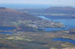
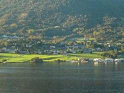 View of the village of Eide | |||
| |||
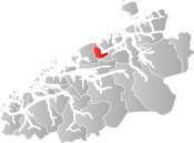 Eide within Møre og Romsdal | |||
| Coordinates: 62°55′41″N 07°22′25″E / 62.92806°N 7.37361°ECoordinates: 62°55′41″N 07°22′25″E / 62.92806°N 7.37361°E | |||
| Country | Norway | ||
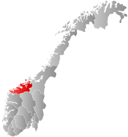
| County | Møre og Romsdal | ||
| District | Nordmøre | ||
| Administrative centre | Eide | ||
| Government | |||
| • Mayor (2015) | Egil Karstein Strand (H) | ||
| Area | |||
| • Total | 152.09 km2 (58.72 sq mi) | ||
| • Land | 145.69 km2 (56.25 sq mi) | ||
| • Water | 6.40 km2 (2.47 sq mi) | ||
| Area rank | #353 in Norway | ||
| Population (2017) | |||
| • Total | 3,454 | ||
| • Rank | #248 in Norway | ||
| • Density | 23.7/km2 (61/sq mi) | ||
| • Change (10 years) | 2.6% | ||
| Demonym(s) | Eidesokning[1] | ||
| Time zone | UTC+01:00 (CET) | ||
| • Summer (DST) | UTC+02:00 (CEST) | ||
| ISO 3166 code | NO-1551 | ||
| Official language form | Bokmål | ||
| Website |
www | ||

Eide is a municipality in Møre og Romsdal county, Norway. It is part of the region of Nordmøre. It is located on the Romsdal peninsula, along the Kornstadfjorden and the Kvernesfjorden. The administrative centre of the municipality is the village of Eide. Other villages include Lyngstad, Vevang, and Visnes.
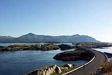
The municipality is known for its traditional and modern limestone (marble) quarries and related crafts industry. The Atlanterhavsveien coastal road connects Eide Municipality to neighboring Averøy Municipality to the east. The municipal border lies at the Storseisundet Bridge on the Atlanterhavsveien road.
The 152-square-kilometre (59 sq mi) municipality is the 353rd largest by area out of the 422 municipalities in Norway. Eide is the 248th most populous municipality in Norway with a population of 3,454. The municipality's population density is 23.7 inhabitants per square kilometre (61/sq mi) and its population has increased by 2.6% over the last decade.[2]
General information
The municipality of Eide was established on 1 January 1897 when it was separated from Kvernes Municipality. The initial population of the municipality was 1,552. On 1 January 1964, the Vevang area (population: 562) was transferred from Kornstad Municipality to Eide Municipality. On 1 January 1983, the uninhabited island of Eldhusøya (now part of the Atlanterhavsveien) was transferred from Eide to Averøy Municipality.[3]
On 1 January 2020, the neighboring municipalities of Eide and Fræna will be merged into the new municipality of Hustadvika.[4][5]
Name
The municipality (originally the parish) is named after the old Eide farm (Old Norse: Eið), since the first church (Eide Church) was built there. The name is identical with the word eið which means "isthmus" or "neck of land".[6]
Coat-of-arms
The coat-of-arms is from modern times. They were granted on 9 July 1982. The arms show three white whooping swans (Cygnus cygnus), which are very common in the many rich lakes in the area. Each swan has seven feathers, representing the seven main villages in the municipality.[7]
Churches
The Church of Norway has one parish (sokn) within the municipality of Eide. It is part of the Ytre Nordmøre deanery in the Diocese of Møre.
| Parish (sokn) | Name | Location | Year built |
|---|---|---|---|
| Eide | Eide Church | Eide | 1871 |
| Gaustad Chapel | Gaustad, near Vevang | 2001 |
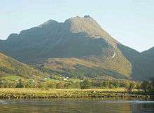
Geography
The municipality is located on the northern part of the Romsdal Peninsula, just west of the island of Averøya. Kvitholmen Lighthouse lies just off the northern coast of the municipality, in an area with hundreds of small islands and skerries. Fræna Municipality lies to the west of Eide, Gjemnes Municipality lies to the southeast, and Averøy Municipality lies to the east. The open Norwegian Sea lies to the north.
Government
All municipalities in Norway, including Eide, are responsible for primary education (through 10th grade), outpatient health services, senior citizen services, unemployment and other social services, zoning, economic development, and municipal roads. The municipality is governed by a municipal council of elected representatives, which in turn elect a mayor.
Municipal council
The municipal council (Kommunestyre) of Eide is made up of 21 representatives that are elected to four year terms. Currently, the party breakdown is as follows:[8]
| Party Name | Name in Norwegian | Number of representatives | |
|---|---|---|---|
| Labour Party | Arbeiderpartiet | 7 | |
| Conservative Party | Høyre | 7 | |
| Christian Democratic Party | Kristelig Folkeparti | 1 | |
| Centre Party | Senterpartiet | 4 | |
| Liberal Party | Venstre | 2 | |
| Local Lists | Lokale lister | 1 | |
| Total number of members: | 21 | ||
References
- ↑ "Navn på steder og personer: Innbyggjarnamn" (in Norwegian). Språkrådet. Retrieved 2015-12-01.
- ↑ Statistisk sentralbyrå (2017). "Table: 06913: Population 1 January and population changes during the calendar year (M)" (in Norwegian). Retrieved 2017-10-09.
- ↑ Jukvam, Dag (1999). "Historisk oversikt over endringer i kommune- og fylkesinndelingen" (PDF) (in Norwegian). Statistisk sentralbyrå.
- ↑ "Hustadvika kommune endelig vedtatt!" (in Norwegian). Fræna kommune. Retrieved 2017-10-09.
- ↑ "Nye Eide og Fræna kommune" (in Norwegian). Retrieved 2017-10-09.
- ↑ Rygh, Oluf (1908). Norske gaardnavne: Romsdals amt (in Norwegian) (13 ed.). Kristiania, Norge: W. C. Fabritius & sønners bogtrikkeri. p. 346.
- ↑ Norske Kommunevåpen (1990). "Nye kommunevåbener i Norden". Retrieved 18 October 2008.
- ↑ "Table: 04813: Members of the local councils, by party/electoral list at the Municipal Council election (M)" (in Norwegian). Statistics Norway. 2015.
External links


- Municipal fact sheet from Statistics Norway (in Norwegian)