Surma, Nepal
| Surma, Nepal सुरमा | |
|---|---|
| Gaunpalika | |
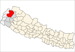
 Surma, Nepal Location in Nepal | |
| Coordinates: 29°39′N 81°04′E / 29.65°N 81.07°ECoordinates: 29°39′N 81°04′E / 29.65°N 81.07°E | |
| Country |
|
| Province | Province No. 7 |
| District | Bajhang District |
| Population (1991) | |
| • Total | 2,002 |
| • Religions | Hindu |
| Time zone | UTC+5:45 (Nepal Time) |
Surma is a former village development committee that is now a Rural Municipality in Bajhang District in Province No. 7 of western Nepal.. At the time of the 1991 Nepal census it had a population of 2,002 and had 367 houses in the village.[1]
References
- ↑ "Nepal Census 2001". Nepal's Village Development Committees. Digital Himalaya. Retrieved 2008-08-27.
This article is issued from
Wikipedia.
The text is licensed under Creative Commons - Attribution - Sharealike.
Additional terms may apply for the media files.