National Register of Historic Places listings in Vigo County, Indiana
This is a list of the National Register of Historic Places listings in Vigo County, Indiana.
This is intended to be a complete list of the properties and districts on the National Register of Historic Places in Vigo County, Indiana, United States. Latitude and longitude coordinates are provided for many National Register properties and districts; these locations may be seen together in a map.[1]
There are 47 properties and districts listed on the National Register in the county, including 1 National Historic Landmark. Another 5 properties were once listed but have been removed.
Properties and districts located in incorporated areas display the name of the municipality, while properties and districts in unincorporated areas display the name of their civil township. Properties and districts split between multiple jurisdictions display the names of all jurisdictions.
- This National Park Service list is complete through NPS recent listings posted June 19, 2020.[2]
Current listings
| [3] | Name on the Register[4] | Image | Date listed[5] | Location | City or town | Description |
|---|---|---|---|---|---|---|
| 1 | Allen Chapel African Methodist Episcopal Church |  Allen Chapel African Methodist Episcopal Church |
September 5, 1975 (#75000030) |
224 Crawford St. 39°27′35″N 87°24′51″W |
Terre Haute | The African Methodist Episcopal congregation in Terre Haute began meeting in 1837. The original structure was part of the Underground Railroad. The Chapel and its school have been noteworthy in the African American culture of the region. |
| 2 | Bethany Congregational Church | 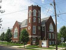 Bethany Congregational Church |
September 28, 2003 (#03000986) |
201 W. Miller Ave. 39°28′01″N 87°26′45″W |
West Terre Haute | |
| 3 | Branch of State Bank of Indiana (Memorial Hall) | 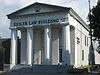 Branch of State Bank of Indiana (Memorial Hall) |
October 25, 1973 (#73000026) |
219 Ohio St. 39°27′55″N 87°24′52″W |
Terre Haute | |
| 4 | Building at 23-27 S. Sixth Street |  Building at 23-27 S. Sixth Street |
June 30, 1983 (#83000111) |
23-27 S. 6th St. 39°27′57″N 87°24′36″W |
Terre Haute | |
| 5 | Building at 510-516 Ohio Street | 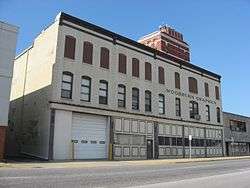 Building at 510-516 Ohio Street |
June 30, 1983 (#83000152) |
510-516 Ohio St. 39°27′57″N 87°24′39″W |
Terre Haute | |
| 6 | Building at 810 Wabash Avenue |  Building at 810 Wabash Avenue |
June 30, 1983 (#83000153) |
810 Wabash Ave. 39°28′00″N 87°24′19″W |
Terre Haute | |
| 7 | Butternut Hill |  Butternut Hill |
May 27, 1993 (#93000469) |
4430 Wabash Ave. 39°28′33″N 87°21′07″W |
Terre Haute | |
| 8 | Carr's Hall |  Carr's Hall |
June 30, 1983 (#83000154) |
329-333 Walnut St. 39°27′52″N 87°24′46″W |
Terre Haute | |
| 9 | Citizens' Trust Company Building | 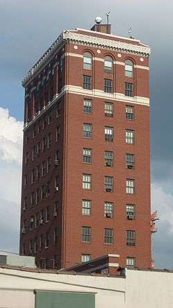 Citizens' Trust Company Building |
June 30, 1983 (#83000156) |
19-21 S. 6th St. 39°27′58″N 87°24′36″W |
Terre Haute | |
| 10 | Collett Park | 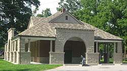 Collett Park |
December 10, 1981 (#81000021) |
N. 7th St. and Maple Ave. 39°29′38″N 87°24′21″W |
Terre Haute | A city park established in 1883 on land donated by railroad entrepreneur Josephus Collett. 21 acres (85,000 m2) in size, the tree-filled park included a pavilion built in 1894 by J. Merrill Sherman. |
| 11 | Collett Park Neighborhood Historic District |  Collett Park Neighborhood Historic District |
March 22, 2004 (#04000207) |
Roughly bounded by 7th St., Maple Ave., 11th St., and Florida Ave. 39°29′44″N 87°24′18″W |
Terre Haute | A residential neighborhood surrounding Collett Park, the district is known for its homes, many built between 1900 and 1920. Architectural styles include Queen Anne Style, Shingle Style and Colonial Revival. |
| 12 | Condit House |  Condit House |
April 2, 1973 (#73000023) |
629 Mulberry St. on the Indiana State University campus 39°28′06″N 87°24′32″W |
Terre Haute | Official residence of the President of Indiana State University; built in 1860 and bequeathed to the University in 1962. Oldest building on the campus. |
| 13 | Eugene V. Debs House |  Eugene V. Debs House |
November 13, 1966 (#66000008) |
451 N. 8th St. 39°28′18″N 87°24′20″W |
Terre Haute | This house was built in 1890 by Eugene V. Debs and his wife Kate. The building, within the campus of Indiana State University, is now a museum commemorating Debs' life. |
| 14 | Paul Dresser Birthplace | 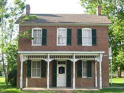 Paul Dresser Birthplace |
January 22, 1973 (#73000024) |
1st and Farrington Sts. 39°27′24″N 87°25′02″W |
Terre Haute | The birthplace and family home of composer Paul Dresser, this structure was originally at a different location in the town. When threatened by urban renewal in the 1960s, the home was moved to its current location in Fairbanks Park near the Wabash River. |
| 15 | Farrington's Grove Historic District | 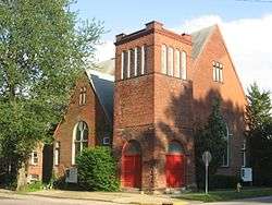 Farrington's Grove Historic District |
February 27, 1986 (#86000270) |
Roughly bounded by Poplar, S. 7th, Hulman, and S. 4th Sts. 39°27′22″N 87°24′35″W |
Terre Haute | |
| 16 | Fire Station No. 9 | 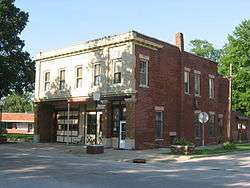 Fire Station No. 9 |
December 16, 1982 (#82000049) |
1728 S. 8th St. 39°26′51″N 87°24′19″W |
Terre Haute | |
| 17 | First Congregational Church |  First Congregational Church |
June 30, 1983 (#83000157) |
630 Ohio St. 39°27′57″N 87°24′33″W |
Terre Haute | |
| 18 | First National Bank | 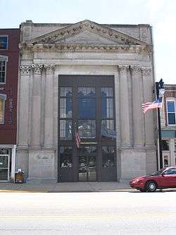 First National Bank |
May 7, 1992 (#83004576) |
509 Wabash Ave. 39°27′59″N 87°24′39″W |
Terre Haute | |
| 19 | Greenwood Elementary School |  Greenwood Elementary School |
September 26, 1997 (#97001177) |
145 E. Voorhees Ave. 39°26′26″N 87°24′56″W |
Terre Haute | |
| 20 | Highland Lawn Cemetery | 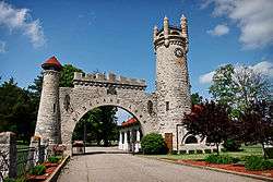 Highland Lawn Cemetery |
November 29, 1990 (#90001790) |
4520 Wabash Ave. 39°28′45″N 87°20′46″W |
Terre Haute | Opened in 1884, the cemetery features Richardsonian Romanesque landscaping and architecture from the late 19th century. Famous interments include Eugene V. Debs, Max Ehrmann, and Valeska Suratt. |
| 21 | Hippodrome Theatre |  Hippodrome Theatre |
June 30, 1983 (#83000110) |
727 Ohio St. 39°27′55″N 87°24′21″W |
Terre Haute | The Hippodrome was designed by noted theater architect John Eberson. The German Renaissance structure opened in 1915 and became a spot for opera, theater, and vaudeville. The building is currently owned by the Scottish Rite. |
| 22 | House at 823 Ohio Street | 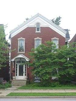 House at 823 Ohio Street |
June 30, 1983 (#83003441) |
823 Ohio St. 39°27′55″N 87°24′18″W |
Terre Haute | |
| 23 | Indiana Theatre |  Indiana Theatre |
November 13, 1997 (#83004578) |
683 Ohio St. 39°27′55″N 87°24′26″W |
Terre Haute | The Theatre was built by Terre Haute resident T.W. Barhydt to be a lasting gift to the city of Terre Haute and it was designed by America’s preeminent designer John Eberson to be his first prototype atmospheric theater which became his signature style that is recognized to be the gold standard of American theatre design. |
| 24 | Linton Township High School and Community Building |  Linton Township High School and Community Building |
March 20, 2002 (#02000200) |
13041 Pimento Circle at Pimento 39°18′30″N 87°23′06″W |
Linton Township | |
| 25 | Markle House and Mill Site | 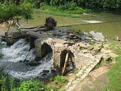 Markle House and Mill Site |
September 10, 1979 (#79000023) |
4900 Mill Dam Rd. at North Terre Haute 39°31′38″N 87°20′48″W |
Otter Creek Township | |
| 26 | Miller-Parrott Baking Company Building | March 11, 2019 (#100003516) |
1450 Wabash Ave. 39°28′07″N 87°23′36″W |
Terre Haute | ||
| 27 | New Goshen District No. 2 School | 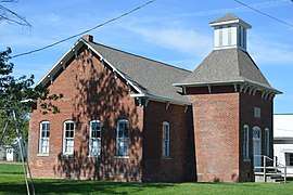 New Goshen District No. 2 School |
September 12, 2016 (#16000613) |
9620 Rangeline Place 39°34′56″N 87°27′45″W |
Fayette Township | |
| 28 | Ohio Boulevard-Deming Park Historic District | 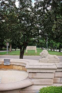 Ohio Boulevard-Deming Park Historic District |
September 14, 1989 (#89001425) |
Roughly Ohio Boulevard from 19th to Keane 39°27′57″N 87°21′39″W |
Terre Haute | Designed by architect and city planner George E. Kessler and developed by landowner Demas Deming, Jr, the boulevard is 1.5 miles (2.4 km) lined with trees and homes, with a median maintained as city park land. |
| 29 | Rea Park | June 12, 2017 (#100001065) |
3500 S. 7th St. 39°25′27″N 87°24′25″W |
Terre Haute | ||
| 30 | Sage-Robinson-Nagel House | 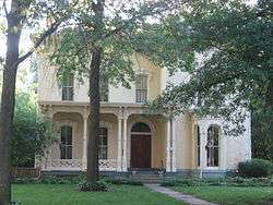 Sage-Robinson-Nagel House |
April 11, 1973 (#73000025) |
1411 S. 6th St. 39°27′07″N 87°24′36″W |
Terre Haute | |
| 31 | Saint Mary-of-the-Woods Historic District | September 18, 2017 (#100001616) |
Roughly bounded by St. Mary's Rd., 1840 Way St., Grove and Orchard Lns., Woods Way, and College Rd. 2 39°30′34″N 87°27′52″W |
Sugar Creek Township | ||
| 32 | Frank Senour Round Barn | 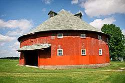 Frank Senour Round Barn |
April 2, 1993 (#93000193) |
6400 E. Oregon Church Rd., northwest of Blackhawk 39°20′07″N 87°19′10″W |
Pierson Township | Built in 1905 in the heyday of round barn construction, it is a true round barn with no angles in its circumference and a conical roof. Part of a multiple listing of historic Indiana barns. |
| 33 | Star Building |  Star Building |
June 30, 1983 (#83000158) |
601-603 Ohio St. 39°27′55″N 87°24′35″W |
Terre Haute | |
| 34 | State Normal Library | 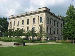 State Normal Library |
June 27, 2002 (#02000690) |
626 Eagle St. 39°28′11″N 87°24′30″W |
Terre Haute | |
| 35 | Terminal Arcade | 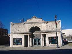 Terminal Arcade |
June 30, 1983 (#83000159) |
822 Wabash Ave. 39°28′00″N 87°24′17″W |
Terre Haute | This beaux-arts structure was designed by Daniel H. Burnham and was originally an interurban train station. Made of terra cotta and brick, it has identical facades on the north and south sides. Currently the building is a bar restaurant. |
| 36 | Terre Haute Fire Station No. 8 |  Terre Haute Fire Station No. 8 |
June 15, 2000 (#00000668) |
1831 Wabash Ave. 39°28′08″N 87°23′19″W |
Terre Haute | |
| 37 | Terre Haute Masonic Temple | 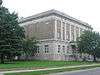 Terre Haute Masonic Temple |
June 9, 1995 (#95000705) |
224 N. 8th St. 39°28′09″N 87°24′22″W |
Terre Haute | |
| 38 | Terre Haute Post Office and Federal Building | 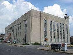 Terre Haute Post Office and Federal Building |
August 13, 1984 (#84003813) |
7th and Cherry Sts. 39°28′02″N 87°24′27″W |
Terre Haute | |
| 39 | Terre Haute YMCA Building | June 3, 2019 (#100004047) |
200 S. 6th St. 39°27′51″N 87°24′36″W |
Terre Haute | ||
| 40 | Twelve Points Historic District | 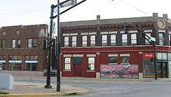 Twelve Points Historic District |
April 20, 2005 (#05000314) |
Lafayette Ave. from Linden to 13th St. and Maple Ave. from Garfield to 13th St. 39°29′31″N 87°23′56″W |
Terre Haute | |
| 41 | Vigo County Courthouse | 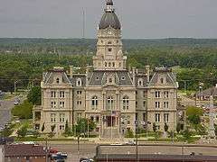 Vigo County Courthouse |
June 30, 1983 (#83000160) |
Courthouse Sq. 39°27′57″N 87°24′52″W |
Terre Haute | Designed by architect Samuel Hannaford in the Second Empire style, the courthouse was dedicated in 1883 and is the seat of government in Vigo County. Features a two-ton bell partially funded by money left in the will of Colonel Francis Vigo. |
| 42 | Vigo County Home for Dependent Children |  Vigo County Home for Dependent Children |
June 15, 2000 (#00000674) |
7140 Wabash Ave., east of Terre Haute 39°29′16″N 87°18′21″W |
Lost Creek Township | |
| 43 | Wabash Avenue-East Historic District | 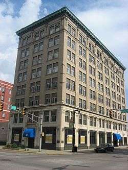 Wabash Avenue-East Historic District |
June 30, 1983 (#83000040) |
Wabash Ave. and 7th and 8th Sts.; also 26-34 8th St.; also roughly bounded by 6th, Ohio, 7th, and Walnut Sts. 39°27′59″N 87°24′24″W |
Terre Haute | Second and third sets of boundaries represent boundary adjustments of September 16, 1992[6] (5 properties removed, one new property added) and September 20, 2006[7] (3 properties removed, 13 new properties added) |
| 44 | Wabash Avenue-West Historic District |  Wabash Avenue-West Historic District |
June 30, 1983 (#83000041) |
Wabash Ave. and 6th St. 39°28′00″N 87°24′39″W |
Terre Haute | |
| 45 | Booker T. Washington School | 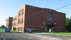 Booker T. Washington School |
October 16, 2002 (#02001170) |
1201 S. 13th St. 39°27′15″N 87°23′53″W |
Terre Haute | |
| 46 | Williams-Warren-Zimmerman House |  Williams-Warren-Zimmerman House |
October 23, 1980 (#80000046) |
900-904 S. 4th St. 39°27′27″N 87°24′44″W |
Terre Haute | |
| 47 | Woodrow Wilson Junior High School | 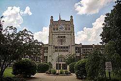 Woodrow Wilson Junior High School |
March 25, 1996 (#96000285) |
301 S. 25th St. 39°27′50″N 87°22′48″W |
Terre Haute |
Former listings
| [3] | Name on the Register | Image | Date listed | Date removed | Location | City or town | Summary |
|---|---|---|---|---|---|---|---|
| 1 | Chamber of Commerce Building | 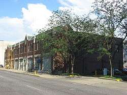 Chamber of Commerce Building |
June 30, 1983 (#83000155) | March 5, 2019 | 627 Cherry St. 39°28′02″N 87°24′31″W |
Terre Haute | |
| 2 | DeWees-Preston-Smith House | December 27, 1982 (#82000048) | July 24, 1989 | 1339 Poplar St. |
Terre Haute | ||
| 3 | Foley Hall | 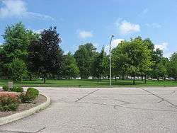 Foley Hall |
March 21, 1985 (#85000595) | March 5, 2019 | Saint Mary-of-the-Woods College campus, off U.S. Route 150 39°30′38″N 87°27′44″W |
Sugar Creek Township | Demolished |
| 4 | House at 209-211 S. Ninth Street |  House at 209-211 S. Ninth Street |
June 30, 1983 (#83000109) | March 5, 2019 | 209-211 S. 9th St. 39°27′50″N 87°24′16″W |
Terre Haute | |
| 5 | Phoenix Club | June 30, 1983 (#83000108) | May 24, 1993 | 201 S. 5th St. |
Terre Haute |
See also
| Wikimedia Commons has media related to National Register of Historic Places in Vigo County, Indiana. |
References
- The latitude and longitude information provided in this table was derived originally from the National Register Information System, which has been found to be fairly accurate for about 99% of listings. Some locations in this table may have been corrected to current GPS standards.
- "National Register of Historic Places: Weekly List Actions". National Park Service, United States Department of the Interior. Retrieved on June 19, 2020.
- Numbers represent an ordering by significant words. Various colorings, defined here, differentiate National Historic Landmarks and historic districts from other NRHP buildings, structures, sites or objects.
- "National Register Information System". National Register of Historic Places. National Park Service. March 13, 2009.
- The eight-digit number below each date is the number assigned to each location in the National Register Information System database, which can be viewed by clicking the number.
| Topics | |
|---|---|
| Lists by state |
|
| Lists by insular areas | |
| Lists by associated state | |
| Other areas | |
| Related | |
| |

Municipalities and communities of Vigo County, Indiana, United States | ||
|---|---|---|
| City | Map of Indiana highlighting Vigo County | |
| Towns | ||
| Townships | ||
| CDPs | ||
| Other unincorporated communities |
| |
| Footnotes | ‡This populated place also has portions in an adjacent county or counties | |