National Register of Historic Places listings in Switzerland County, Indiana
This is a list of the National Register of Historic Places listings in Switzerland County, Indiana.
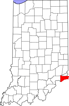
Location of Switzerland County in Indiana
This is intended to be a complete list of the properties on the National Register of Historic Places in Switzerland County, Indiana, United States. Latitude and longitude coordinates are provided for many National Register properties; these locations may be seen together in a map.[1]
There are 9 properties listed on the National Register in the county.
Properties and districts located in incorporated areas display the name of the municipality, while properties and districts in unincorporated areas display the name of their civil township. Properties and districts split between multiple jurisdictions display the names of all jurisdictions.
- This National Park Service list is complete through NPS recent listings posted June 19, 2020.[2]
Current listings
| [3] | Name on the Register[4] | Image | Date listed[5] | Location | City or town | Description |
|---|---|---|---|---|---|---|
| 1 | Edward and George Cary Eggleston House | 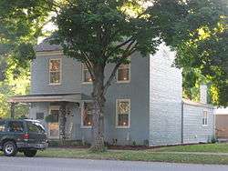 Edward and George Cary Eggleston House |
October 15, 1973 (#73000046) |
306 W. Main St. 38°44′46″N 85°04′11″W |
Vevay | |
| 2 | Merit-Tandy Farmstead |  Merit-Tandy Farmstead |
April 29, 1977 (#77000021) |
Northeast of Patriot on State Road 156 38°52′05″N 84°47′35″W |
Posey Township | |
| 3 | Old Hoosier Theatre | .jpg) Old Hoosier Theatre |
March 1, 1982 (#82000077) |
Cheapside and Ferry Sts. 38°44′50″N 85°04′01″W |
Vevay | |
| 4 | Benjamin Schenck Mansion |  Benjamin Schenck Mansion |
October 16, 2002 (#02001174) |
206 W. Turnpike St. 38°45′02″N 85°04′24″W |
Vevay | |
| 5 | Switzerland County Courthouse | .jpg) Switzerland County Courthouse |
June 17, 2009 (#09000435) |
212 W. Main St. 38°44′49″N 85°04′08″W |
Vevay | |
| 6 | Thiebaud Farmstead | 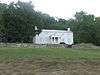 Thiebaud Farmstead |
June 22, 2004 (#04000629) |
531 State Road 56, southwest of Vevay 38°42′59″N 85°06′58″W |
Craig Township | |
| 7 | Venoge Farmstead | 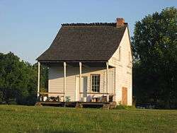 Venoge Farmstead |
January 2, 1997 (#96001539) |
111 State Road 129, west of Vevay 38°44′42″N 85°05′49″W |
Craig Township | |
| 8 | Vevay Historic District | December 2, 2019 (#100004722) |
Roughly bounded by Seminary St., Market St., Arch St., Pearl St. & Main St. 38°44′55″N 85°04′06″W |
Vevay | ||
| 9 | Thomas T. Wright House |  Thomas T. Wright House |
December 10, 1980 (#80000066) |
Southwest of Vevay on State Road 56 38°42′43″N 85°07′26″W |
Craig Township |
See also
| Wikimedia Commons has media related to National Register of Historic Places in Switzerland County, Indiana. |
References
- The latitude and longitude information provided in this table was derived originally from the National Register Information System, which has been found to be fairly accurate for about 99% of listings. Some locations in this table may have been corrected to current GPS standards.
- "National Register of Historic Places: Weekly List Actions". National Park Service, United States Department of the Interior. Retrieved on June 19, 2020.
- Numbers represent an ordering by significant words. Various colorings, defined here, differentiate National Historic Landmarks and historic districts from other NRHP buildings, structures, sites or objects.
- "National Register Information System". National Register of Historic Places. National Park Service. March 13, 2009.
- The eight-digit number below each date is the number assigned to each location in the National Register Information System database, which can be viewed by clicking the number.
| Topics | |
|---|---|
| Lists by state |
|
| Lists by insular areas | |
| Lists by associated state | |
| Other areas | |
| Related | |
| |

Municipalities and communities of Switzerland County, Indiana, United States | ||
|---|---|---|
| Towns | Map of Indiana highlighting Switzerland County | |
| Townships | ||
| CDPs | ||
| Other unincorporated communities | ||
This article is issued from Wikipedia. The text is licensed under Creative Commons - Attribution - Sharealike. Additional terms may apply for the media files.