National Register of Historic Places listings in Hendricks County, Indiana
This is a list of the National Register of Historic Places listings in Hendricks County, Indiana.
This is intended to be a complete list of the properties and districts on the National Register of Historic Places in Hendricks County, Indiana, United States. Latitude and longitude coordinates are provided for many National Register properties and districts; these locations may be seen together in a map.[1]
There are 22 properties and districts listed on the National Register in the county.
Properties and districts located in incorporated areas display the name of the municipality, while properties and districts in unincorporated areas display the name of their civil township. Properties and districts split between multiple jurisdictions display the names of all jurisdictions.
- This National Park Service list is complete through NPS recent listings posted June 19, 2020.[2]
Current listings
| [3] | Name on the Register[4] | Image | Date listed[5] | Location | City or town | Description |
|---|---|---|---|---|---|---|
| 1 | Ora Adams House | 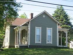 Ora Adams House |
June 17, 2009 (#09000425) |
301-303 E. Main St. 39°45′39″N 86°31′13″W |
Danville | |
| 2 | Amo THI & E Interurban Depot/Substation | 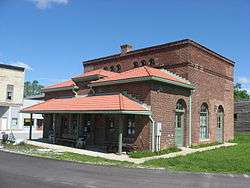 Amo THI & E Interurban Depot/Substation |
January 25, 2007 (#06001294) |
4985 Railroad St. 39°41′18″N 86°36′48″W |
Amo | |
| 3 | Forest W. and Jeannette Wales Blanton House | 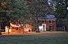 Forest W. and Jeannette Wales Blanton House |
September 12, 2016 (#16000612) |
625 N. Washington St. 39°46′14″N 86°31′23″W |
Danville | |
| 4 | Leander Campbell House | 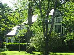 Leander Campbell House |
September 28, 2003 (#03000981) |
498 E. Broadway St. 39°45′29″N 86°30′58″W |
Danville | |
| 5 | Danville Courthouse Square Historic District | 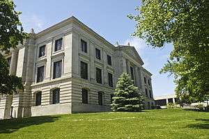 Danville Courthouse Square Historic District |
December 27, 2010 (#02001559) |
Roughly bounded by Clinton, Tennessee, Broadway, and Cross Sts. 39°45′37″N 86°31′26″W |
Danville | |
| 6 | Danville Main Street Historic District | 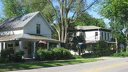 Danville Main Street Historic District |
September 8, 1994 (#94001109) |
Bounded by East, Main, Cross, and Marion Sts. 39°45′37″N 86°31′42″W |
Danville | |
| 7 | Dr. Jeremiah and Ann Jane DePew House | 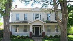 Dr. Jeremiah and Ann Jane DePew House |
September 20, 2006 (#06000850) |
292 E. Broadway St. 39°45′33″N 86°31′14″W |
Danville | |
| 8 | Hendricks County Bridge Number 316 | 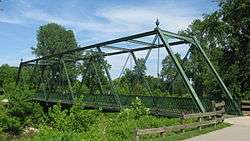 Hendricks County Bridge Number 316 |
March 26, 2003 (#03000140) |
Center Rd., Friendship Gardens over White Lick Creek 39°41′47″N 86°24′07″W |
Plainfield | |
| 9 | Hendricks County Jail and Sheriff's Residence |  Hendricks County Jail and Sheriff's Residence |
June 30, 1983 (#83000125) |
170 S. Washington St. 39°45′32″N 86°31′27″W |
Danville | |
| 10 | Hendricks County Poor Asylum | December 3, 2018 (#100003181) |
865 E. Main St. 39°45′28″N 86°30′18″W |
Center Township | ||
| 11 | Joel Jessup Farm | 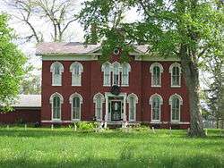 Joel Jessup Farm |
August 14, 1998 (#98001049) |
County Road 800S near County Road 1050E, northwest of Friendswood 39°38′44″N 86°20′09″W |
Guilford Township | |
| 12 | Noah and Hannah Hadley Kellum House | 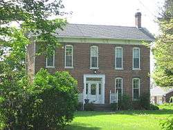 Noah and Hannah Hadley Kellum House |
March 3, 1995 (#95000204) |
7290 S. County Road 1050E, northwest of Friendswood 39°39′25″N 86°20′11″W |
Guilford Township | |
| 13 | Kellum-Jessup-Chandler Farm | 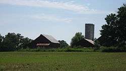 Kellum-Jessup-Chandler Farm |
September 8, 1994 (#94001111) |
6726 S. White Lick Creek Rd., southeast of Plainfield 39°39′55″N 86°20′36″W |
Guilford Township | |
| 14 | John W. McClain House | 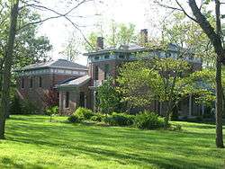 John W. McClain House |
June 22, 2004 (#04000633) |
1445 S. County Road 525E, southwest of Avon 39°44′59″N 86°25′44″W |
Washington Township | |
| 15 | McCormack-Bowman House | 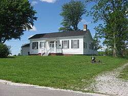 McCormack-Bowman House |
March 20, 1995 (#95000200) |
County Road 200W, 0.5 miles south of its junction with U.S. Route 40 and southwest of Clayton 39°38′50″N 86°33′37″W |
Franklin Township | |
| 16 | A.A. Parsons Farmstead | 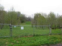 A.A. Parsons Farmstead |
September 30, 2014 (#14000803) |
1739 S625E 39°44′14″N 86°25′10″W |
Washington Township | |
| 17 | Plainfield Historic District |  Plainfield Historic District |
March 31, 2010 (#10000121) |
Roughly bounded by Lincoln St to the north; S. East St. to the east; Ash St. to the south; and S. Mill St to the west 39°42′11″N 86°24′09″W |
Plainfield | |
| 18 | Smith Farm | 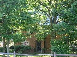 Smith Farm |
December 19, 2007 (#07001279) |
2698 S. County Road 900E, northeast of Plainfield 39°43′34″N 86°21′42″W |
Washington Township | |
| 19 | Sugar Grove Meetinghouse and Cemetery | 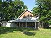 Sugar Grove Meetinghouse and Cemetery |
September 22, 2000 (#00001137) |
Junction of County Roads 700E and 600S 39°40′29″N 86°24′01″W |
Guilford Township | |
| 20 | THI and E Interurban Depot-Substation | 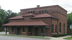 THI and E Interurban Depot-Substation |
December 19, 2002 (#02001562) |
401 S. Vine St. 39°42′01″N 86°24′01″W |
Plainfield | |
| 21 | Twin Bridges | 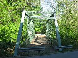 Twin Bridges |
March 15, 2000 (#00000200) |
County Road 150E over White Lick Creek 39°45′15″N 86°30′15″W |
Danville | |
| 22 | Wilson-Courtney House |  Wilson-Courtney House |
February 9, 1984 (#84001044) |
10 Cartersburg Rd. 39°45′10″N 86°31′14″W |
Danville |
See also
| Wikimedia Commons has media related to National Register of Historic Places in Hendricks County, Indiana. |
References
- The latitude and longitude information provided in this table was derived originally from the National Register Information System, which has been found to be fairly accurate for about 99% of listings. Some locations in this table may have been corrected to current GPS standards.
- "National Register of Historic Places: Weekly List Actions". National Park Service, United States Department of the Interior. Retrieved on June 19, 2020.
- Numbers represent an ordering by significant words. Various colorings, defined here, differentiate National Historic Landmarks and historic districts from other NRHP buildings, structures, sites or objects.
- "National Register Information System". National Register of Historic Places. National Park Service. March 13, 2009.
- The eight-digit number below each date is the number assigned to each location in the National Register Information System database, which can be viewed by clicking the number.
| Topics | |
|---|---|
| Lists by state |
|
| Lists by insular areas | |
| Lists by associated state | |
| Other areas | |
| Related | |
| |

Municipalities and communities of Hendricks County, Indiana, United States | ||
|---|---|---|
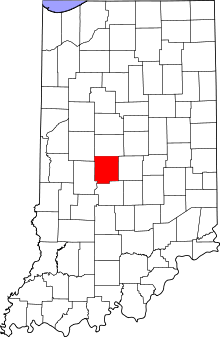
| Towns | Map of Indiana highlighting Hendricks County | |
| Townships | ||
| Unincorporated communities | ||
| Footnotes | ‡This populated place also has portions in an adjacent county or counties | |