National Register of Historic Places listings in Adams County, Indiana
This is a list of the National Register of Historic Places listings in Adams County, Indiana.
This is intended to be a complete list of the properties and districts on the National Register of Historic Places in Adams County, Indiana, United States. Latitude and longitude coordinates are provided for many National Register properties and districts; these locations may be seen together in a map.[1]
There are 9 properties and districts listed on the National Register in the county.
Properties and districts located in incorporated areas display the name of the municipality, while properties and districts in unincorporated areas display the name of their civil township. Properties and districts split between multiple jurisdictions display the names of all jurisdictions.
- This National Park Service list is complete through NPS recent listings posted June 19, 2020.[2]
Current listings
| [3] | Name on the Register[4] | Image | Date listed[5] | Location | City or town | Description |
|---|---|---|---|---|---|---|
| 1 | Adams County Courthouse | 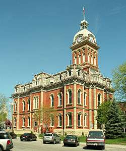 Adams County Courthouse |
September 17, 2008 (#08000914) |
112 S. 2nd St. 40°49′47″N 84°55′28″W |
Decatur | |
| 2 | John S. Bowers House |  John S. Bowers House |
March 5, 1982 (#82000055) |
104 Marshall St. 40°50′04″N 84°55′26″W |
Decatur | |
| 3 | Ceylon Covered Bridge | 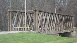 Ceylon Covered Bridge |
January 25, 2007 (#06001289) |
County Road 900S over the Wabash River in Limberlost County Park, northeast of Ceylon 40°36′51″N 84°56′35″W |
Wabash Township | |
| 4 | Ben Colter Polygonal Barn | 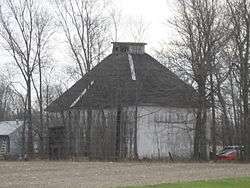 Ben Colter Polygonal Barn |
April 2, 1993 (#93000194) |
Eastern side of State Road 101, 0.6 miles south of its junction with Piqua Rd. and north of Pleasant Mills 40°47′53″N 84°50′27″W |
St. Marys Township | |
| 5 | Charles Dugan House |  Charles Dugan House |
December 22, 2009 (#09001124) |
420 W. Monroe St. 40°49′52″N 84°55′40″W |
Decatur | |
| 6 | Geneva Downtown Commercial Historic District | 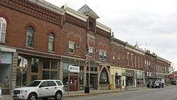 Geneva Downtown Commercial Historic District |
March 21, 2002 (#02000196) |
144-455 E. Line St. 40°35′33″N 84°57′33″W |
Geneva | |
| 7 | Grand Rapids and Indiana Railroad Depot |  Grand Rapids and Indiana Railroad Depot |
March 6, 2017 (#100000712) |
111 N. 7th St. 40°49′44″N 84°55′48″W |
Decatur | |
| 8 | Lenhart Farmhouse |  Lenhart Farmhouse |
June 27, 2002 (#02000688) |
6929 N. Piqua Rd., north of Decatur 40°50′47″N 84°55′12″W |
Root Township | |
| 9 | Gene Stratton Porter Cabin | 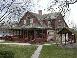 Gene Stratton Porter Cabin |
June 27, 1974 (#74000027) |
200 E. 6th St. 40°35′13″N 84°57′36″W |
Geneva |
See also
| Wikimedia Commons has media related to National Register of Historic Places in Adams County, Indiana. |
References
- The latitude and longitude information provided in this table was derived originally from the National Register Information System, which has been found to be fairly accurate for about 99% of listings. Some locations in this table may have been corrected to current GPS standards.
- "National Register of Historic Places: Weekly List Actions". National Park Service, United States Department of the Interior. Retrieved on June 19, 2020.
- Numbers represent an ordering by significant words. Various colorings, defined here, differentiate National Historic Landmarks and historic districts from other NRHP buildings, structures, sites or objects.
- "National Register Information System". National Register of Historic Places. National Park Service. March 13, 2009.
- The eight-digit number below each date is the number assigned to each location in the National Register Information System database, which can be viewed by clicking the number.
| Topics | |
|---|---|
| Lists by state |
|
| Lists by insular areas | |
| Lists by associated state | |
| Other areas | |
| Related | |
| |

Municipalities and communities of Adams County, Indiana, United States | ||
|---|---|---|
| Cities | Map of Indiana highlighting Adams County | |
| Towns | ||
| Townships | ||
| Unincorporated communities | ||