National Register of Historic Places listings in Morgan County, Indiana
This is a list of the National Register of Historic Places listings in Morgan County, Indiana.
This is intended to be a complete list of the properties and districts on the National Register of Historic Places in Morgan County, Indiana, United States. Latitude and longitude coordinates are provided for many National Register properties and districts; these locations may be seen together in a map.[1]
There are 27 properties and districts listed on the National Register in the county. Another 3 properties were once listed but have been removed.
Properties and districts located in incorporated areas display the name of the municipality, while properties and districts in unincorporated areas display the name of their civil townships. Properties and districts split between multiple jurisdictions display the names of all jurisdictions.
- This National Park Service list is complete through NPS recent listings posted June 19, 2020.[2]
Current listings
| [3] | Name on the Register[4] | Image | Date listed[5] | Location | City or town | Description |
|---|---|---|---|---|---|---|
| 1 | Blackstone House and Martinsville Telephone Company Building |  Blackstone House and Martinsville Telephone Company Building |
January 2, 1997 (#96001540) |
127 S. Main St. 39°25′32″N 86°25′42″W |
Martinsville | |
| 2 | Blankenship-Hodges-Brown House | Blankenship-Hodges-Brown House |
September 15, 2005 (#05001012) |
7455 W. Old State Road 67, southwest of Paragon 39°23′38″N 86°33′59″W |
Ray Township | |
| 3 | Bradford Estate |  Bradford Estate |
April 3, 1989 (#89000236) |
5040 N. State Road 67, north of Martinsville 39°29′56″N 86°25′30″W |
Clay Township | |
| 4 | Cedar Point Farm |  Cedar Point Farm |
March 26, 2003 (#03000148) |
8185 E. State Road 252, west of Morgantown 39°22′14″N 86°16′47″W |
Jackson Township | |
| 5 | Crawford-Gilpin House |  Crawford-Gilpin House |
June 24, 2008 (#08000558) |
339 S. Ohio St. 39°25′26″N 86°25′24″W |
Martinsville | |
| 6 | Cross School | 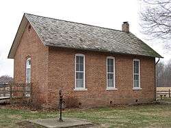 Cross School |
June 16, 1983 (#83000142) |
Voiles and Townsend Rds., southeast of Martinsville 39°23′27″N 86°22′53″W |
Washington Township | |
| 7 | East Washington Street Historic District | 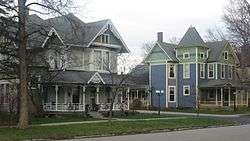 East Washington Street Historic District |
April 18, 1997 (#97000306) |
Roughly E. Washington St. from Sycamore St. to Crawford St. 39°25′37″N 86°25′17″W |
Martinsville | |
| 8 | Elm Spring Farm | 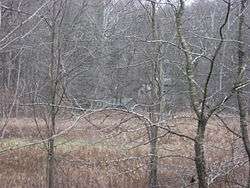 Elm Spring Farm |
September 16, 2001 (#01000981) |
1 mile (1.6 km) north of Bain Rd. on Goose Creek Rd., northwest of Martinsville 39°27′22″N 86°28′13″W |
Jefferson Township | |
| 9 | Grassyfork Fisheries Farm No. 1 |  Grassyfork Fisheries Farm No. 1 |
July 10, 2012 (#12000189) |
2902 E. Morgan St., northeast of Martinsville 39°26′37″N 86°23′26″W |
Washington Township | |
| 10 | Hall School |  Hall School |
September 29, 2004 (#04001100) |
5955 W. Hurt Rd., southwest of Monrovia 39°32′59″N 86°32′24″W |
Gregg Township | |
| 11 | Lake Ditch Bridge |  Lake Ditch Bridge |
September 16, 2001 (#01000986) |
Junction of Lake Ditch and Lake Ditch Rd., west of Monrovia 39°34′35″N 86°31′35″W |
Monroe Township | |
| 12 | Lamb's Creek Bridge |  Lamb's Creek Bridge |
December 28, 2000 (#00001541) |
Junction of Lamb's Creek and W. Old State Road 67, west of Martinsville 39°25′26″N 86°28′31″W |
Jefferson Township | |
| 13 | Franklin Landers-Black and Adams Farm |  Franklin Landers-Black and Adams Farm |
September 22, 2000 (#00001142) |
2430 S. Old State Road 67 39°32′13″N 86°22′25″W |
Brooklyn and Clay Township | |
| 14 | Long Schoolhouse |  Long Schoolhouse |
September 9, 1999 (#99001106) |
0.5 miles (0.80 km) northwest of the junction of Jordan Rd. and Hinson Rd., south of Martinsville 39°22′05″N 86°27′04″W |
Washington Township | |
| 15 | Martinsville Commercial Historic District |  Martinsville Commercial Historic District |
April 1, 1998 (#98000300) |
Roughly bounded by Pike, Mulberry, Jackson, and Sycamore Sts. 39°25′39″N 86°25′41″W |
Martinsville | |
| 16 | Martinsville High School Gymnasium |  Martinsville High School Gymnasium |
July 30, 1981 (#81000004) |
759 S. Main St. 39°25′09″N 86°25′40″W |
Martinsville | |
| 17 | Martinsville Northside Historic District | 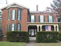 Martinsville Northside Historic District |
January 2, 1997 (#96001541) |
Roughly bounded by Cunningham, Mulberry, Pike, and Graham Sts. 39°25′50″N 86°25′30″W |
Martinsville | |
| 18 | Martinsville Sanitarium |  Martinsville Sanitarium |
December 6, 2005 (#05001368) |
239 W. Harrison St. 39°25′46″N 86°25′54″W |
Martinsville | |
| 19 | Martinsville Vandalia Depot | 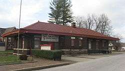 Martinsville Vandalia Depot |
March 14, 1991 (#91000268) |
210 N. Marion St. 39°25′45″N 86°25′52″W |
Martinsville | |
| 20 | Mooresville Commercial Historic District |  Mooresville Commercial Historic District |
March 26, 2003 (#03000147) |
Roughly one block north, south, east, and west of the corner of Main and Indiana 39°36′46″N 86°22′32″W |
Mooresville | |
| 21 | Mooresville Friends Academy Building |  Mooresville Friends Academy Building |
May 12, 1975 (#75000008) |
244 N. Monroe St. 39°36′54″N 86°22′53″W |
Mooresville | |
| 22 | Mooresville Gymnasium |  Mooresville Gymnasium |
June 20, 1997 (#97000598) |
244 N. Monroe St. 39°36′56″N 86°22′53″W |
Mooresville | |
| 23 | Morgan County Courthouse | 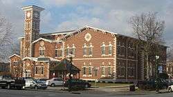 Morgan County Courthouse |
January 11, 1996 (#95001531) |
Courthouse Square 39°25′39″N 86°25′41″W |
Martinsville | |
| 24 | Morgan County Sheriff's House and Jail |  Morgan County Sheriff's House and Jail |
May 30, 1996 (#96000602) |
110 W. Washington St. 39°25′38″N 86°25′48″W |
Martinsville | |
| 25 | Morgantown Historic District |  Morgantown Historic District |
June 21, 2006 (#06000519) |
Approximately 4.5 blocks centered on Washington St., between Marion St. and east of Church St. 39°22′24″N 86°15′40″W |
Morgantown | |
| 26 | Neely House | 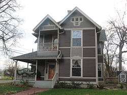 Neely House |
March 15, 2000 (#00000203) |
739 E. Washington St. 39°25′36″N 86°25′11″W |
Martinsville | |
| 27 | Wilbur School | 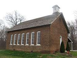 Wilbur School |
May 27, 1993 (#93000473) |
Wilbur Rd. at Wilbur 39°30′49″N 86°29′16″W |
Gregg Township |
Former listings
| [3] | Name on the Register | Image | Date listed | Date removed | Location | City or town | Summary |
|---|---|---|---|---|---|---|---|
| 1 | Burton Lane Bridge | April 14, 1997 (#97000302) | June 1, 2004 | Burton Ln. over Indian Creek, 0.3 miles south of State Road 37 |
Martinsville | ||
| 2 | Hastings Schoolhouse | March 12, 1999 (#99000299) | June 1, 2004 | 0.2 miles south of the junction of Hacker Creek Rd. and Liberty Church Rd. |
Martinsville | ||
| 3 | Hite-Finney House |  Hite-Finney House |
January 11, 1996 (#95001532) | June 15, 2012 | 183 N. Jefferson St. 39°25′42″N 86°25′37″W |
Martinsville |
See also
| Wikimedia Commons has media related to National Register of Historic Places in Morgan County, Indiana. |
References
- The latitude and longitude information provided in this table was derived originally from the National Register Information System, which has been found to be fairly accurate for about 99% of listings. Some locations in this table may have been corrected to current GPS standards.
- "National Register of Historic Places: Weekly List Actions". National Park Service, United States Department of the Interior. Retrieved on June 19, 2020.
- Numbers represent an ordering by significant words. Various colorings, defined here, differentiate National Historic Landmarks and historic districts from other NRHP buildings, structures, sites or objects.
- "National Register Information System". National Register of Historic Places. National Park Service. March 13, 2009.
- The eight-digit number below each date is the number assigned to each location in the National Register Information System database, which can be viewed by clicking the number.
| Topics | |
|---|---|
| Lists by state |
|
| Lists by insular areas | |
| Lists by associated state | |
| Other areas | |
| Related | |
| |

Municipalities and communities of Morgan County, Indiana, United States | ||
|---|---|---|
| City | Map of Indiana highlighting Morgan County | |
| Towns | ||
| Townships | ||
| CDP | ||
| Other unincorporated communities |
| |
| Footnotes | ‡This populated place also has portions in an adjacent county or counties | |