National Register of Historic Places listings in Grant County, Indiana
This is a list of the National Register of Historic Places listings in Grant County, Indiana.

This is intended to be a complete list of the properties and districts on the National Register of Historic Places in Grant County, Indiana, United States. Latitude and longitude coordinates are provided for many National Register properties and districts; these locations may be seen together in a map.[1]
There are 19 properties and districts listed on the National Register in the county, including 1 National Historic Landmark.
Properties and districts located in incorporated areas display the name of the municipality, while properties and districts in unincorporated areas display the name of their civil township. Properties and districts split between multiple jurisdictions display the names of all jurisdictions.
- This National Park Service list is complete through NPS recent listings posted June 19, 2020.[2]
Current listings
| [3] | Name on the Register[4] | Image | Date listed[5] | Location | City or town | Description |
|---|---|---|---|---|---|---|
| 1 | Baldwin Addition Historic District | 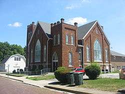 Baldwin Addition Historic District |
September 9, 1999 (#99001108) |
Roughly along Main St., between 2nd and 4th Sts. 40°25′06″N 85°39′00″W |
Fairmount | |
| 2 | Cumberland Covered Bridge | Cumberland Covered Bridge |
May 22, 1978 (#78000032) |
CR 1000 over the Mississinewa River 40°23′19″N 85°29′05″W |
Jefferson Township and Matthews | |
| 3 | Fairmount Commercial Historic District | 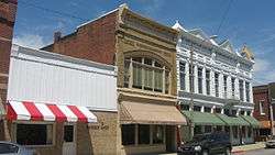 Fairmount Commercial Historic District |
March 12, 1999 (#99000295) |
205-101 and 124-102 S. Main, 102-124 and 101-123 N. Main, 107 W. 1st, and 119-117 W. Washington 40°24′57″N 85°39′02″W |
Fairmount | |
| 4 | First Presbyterian Church | December 3, 2018 (#100003184) |
216 W. 6th St. 40°33′22″N 85°39′43″W |
Marion | ||
| 5 | Gas City High School |  Gas City High School |
March 5, 2004 (#03001316) |
400 E. South A St. 40°29′11″N 85°36′31″W |
Gas City | |
| 6 | Grant County Jail and Sheriff's Residence | 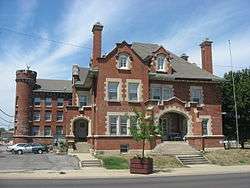 Grant County Jail and Sheriff's Residence |
November 19, 1990 (#83004526) |
215 E. 3rd St. 40°33′33″N 85°39′28″W |
Marion | |
| 7 | Abijah C. Jay House | 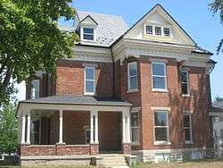 Abijah C. Jay House |
March 27, 2003 (#03000145) |
118 W. 7th St. 40°33′19″N 85°39′39″W |
Marion | |
| 8 | Israel Jenkins House |  Israel Jenkins House |
March 26, 2003 (#03000139) |
7453 E400S, southeast of Marion 40°29′49″N 85°31′40″W |
Monroe Township | |
| 9 | Marion Branch, National Home for Disabled Volunteer Soldiers Historic District | 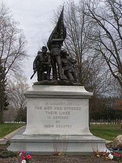 Marion Branch, National Home for Disabled Volunteer Soldiers Historic District |
August 2, 1999 (#99000833) |
1700 E. 38th St. 40°31′12″N 85°38′02″W |
Marion | |
| 10 | Marion Downtown Commercial Historic District |  Marion Downtown Commercial Historic District |
March 17, 1994 (#94000226) |
Roughly bounded by 7th, 2nd, Branson, and Gallatin Sts. 40°33′27″N 85°39′35″W |
Marion | |
| 11 | Marion PCC & St. Louis Railroad Depot | September 4, 2018 (#100002861) |
1002 S. Washington St. 40°33′06″N 85°39′36″W |
Marion | ||
| 12 | Meshingomesia (Mihsiinkweemisa) Cemetery and Indian School Historic District | 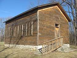 Meshingomesia (Mihsiinkweemisa) Cemetery and Indian School Historic District |
January 9, 2013 (#12001149) |
3820 W600N, northeast of Jalapa 40°38′28″N 85°43′50″W |
Pleasant Township | |
| 13 | J.W. Patterson House | 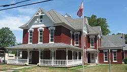 J.W. Patterson House |
November 14, 1979 (#79000016) |
203 and 209 E. Washington St. 40°24′57″N 85°38′57″W |
Fairmount | 209 Washington represents a boundary increase of January 18, 1985 |
| 14 | Aaron Swayzee House |  Aaron Swayzee House |
June 16, 1983 (#83000124) |
224 N. Washington St. 40°33′50″N 85°39′32″W |
Marion | |
| 15 | Thompson-Ray House | 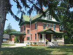 Thompson-Ray House |
September 24, 2009 (#09000756) |
407 E. Main St. 40°29′18″N 85°36′31″W |
Gas City | |
| 16 | George, Jr. and Marie Daugherty Webster House |  George, Jr. and Marie Daugherty Webster House |
June 17, 1992 (#92000678) |
926 S. Washington St. 40°33′09″N 85°39′37″W |
Marion | |
| 17 | West Ward School |  West Ward School |
December 19, 1985 (#85003226) |
210 W. North A St. 40°29′21″N 85°37′02″W |
Gas City | |
| 18 | J. Woodrow Wilson House | 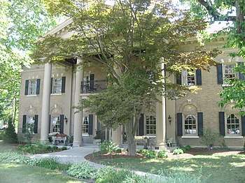 J. Woodrow Wilson House |
August 11, 1988 (#88001218) |
723 W. 4th St. 40°33′27″N 85°40′04″W |
Marion | |
| 19 | Woodside | %2C_May_2011.jpg) Woodside |
December 24, 1997 (#97001538) |
1119 Overlook Rd., north of Marion 40°35′20″N 85°40′28″W |
Washington Township | A Frank Lloyd Wright-designed Usonion home |
See also
| Wikimedia Commons has media related to National Register of Historic Places in Grant County, Indiana. |
References
- The latitude and longitude information provided in this table was derived originally from the National Register Information System, which has been found to be fairly accurate for about 99% of listings. Some locations in this table may have been corrected to current GPS standards.
- "National Register of Historic Places: Weekly List Actions". National Park Service, United States Department of the Interior. Retrieved on June 19, 2020.
- Numbers represent an ordering by significant words. Various colorings, defined here, differentiate National Historic Landmarks and historic districts from other NRHP buildings, structures, sites or objects.
- "National Register Information System". National Register of Historic Places. National Park Service. March 13, 2009.
- The eight-digit number below each date is the number assigned to each location in the National Register Information System database, which can be viewed by clicking the number.
| Topics | |
|---|---|
| Lists by state |
|
| Lists by insular areas | |
| Lists by associated state | |
| Other areas | |
| Related | |
| |

Municipalities and communities of Grant County, Indiana, United States | ||
|---|---|---|
| Cities | Map of Indiana highlighting Grant County | |
| Towns | ||
| Townships | ||
| CDPs | ||
| Unincorporated communities | ||
| Footnotes | ‡This populated place also has portions in an adjacent county or counties | |