National Register of Historic Places listings in Warrick County, Indiana
This is a list of the National Register of Historic Places listings in Warrick County, Indiana.
This is intended to be a complete list of the properties and districts on the National Register of Historic Places in Warrick County, Indiana, United States. Latitude and longitude coordinates are provided for many National Register properties and districts; these locations may be seen together in a map.[1]
There are 8 properties and districts listed on the National Register in the county.
Properties and districts located in incorporated areas display the name of the municipality, while properties and districts in unincorporated areas display the name of their civil township. Properties and districts split between multiple jurisdictions display the names of all jurisdictions.
- This National Park Service list is complete through NPS recent listings posted June 19, 2020.[2]
Current listings
| [3] | Name on the Register[4] | Image | Date listed[5] | Location | City or town | Description |
|---|---|---|---|---|---|---|
| 1 | Angel Mounds |  Angel Mounds |
October 15, 1966 (#66000124) |
8215 Pollack Ave.[6] 37°56′35″N 87°27′06″W |
Ohio Township | Extends into Vanderburgh County |
| 2 | Boonville Public Square Historic District | 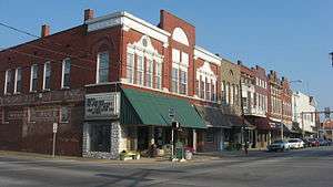 Boonville Public Square Historic District |
January 23, 1987 (#86002720) |
Bounded roughly by 1st, Sycamore, 4th, and Walnut 38°02′57″N 87°16′29″W |
Boonville | |
| 3 | Ellerbusch Archeological Site (12W56) | 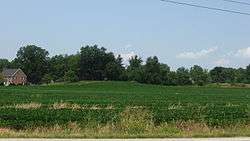 Ellerbusch Archeological Site (12W56) |
March 14, 1991 (#91000270) |
Atop the bluff northwest of the junction of State Road 662 and Ellerbursch Rd., west of Newburgh[7] 37°57′09″N 87°25′32″W |
Ohio Township | |
| 4 | Old Newburgh Presbyterian Church | 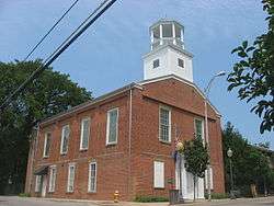 Old Newburgh Presbyterian Church |
May 23, 1978 (#78000040) |
N. State and W. Main Sts. 37°56′44″N 87°24′19″W |
Newburgh | |
| 5 | Old Warrick County Jail | 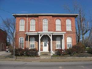 Old Warrick County Jail |
February 14, 1979 (#79000025) |
124 E. Main St. 38°03′01″N 87°16′24″W |
Boonville | |
| 6 | Original Newburgh Historic District | 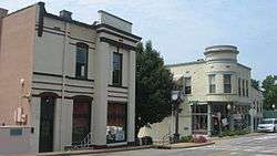 Original Newburgh Historic District |
June 16, 1983 (#83000162) |
Roughly bounded by State Road 662 and Water, Monroe, Main, and Middle Sts. 37°56′40″N 87°24′19″W |
Newburgh | |
| 7 | Roberts-Morton House | 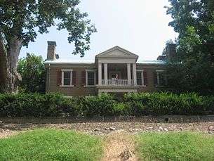 Roberts-Morton House |
December 16, 1974 (#74000024) |
1.5 miles east of Newburgh on State Road 662 37°56′12″N 87°22′46″W |
Ohio Township | |
| 8 | Yankeetown Archeological Site | 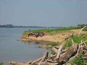 Yankeetown Archeological Site |
February 28, 1979 (#79000026) |
Along the Ohio River bank in Section 21 of Anderson Township, south of Yankeetown[8] 37°54′01″N 87°18′22″W |
Anderson Township |
See also
| Wikimedia Commons has media related to National Register of Historic Places in Warrick County, Indiana. |
References
- The latitude and longitude information provided in this table was derived originally from the National Register Information System, which has been found to be fairly accurate for about 99% of listings. Some locations in this table may have been corrected to current GPS standards.
- "National Register of Historic Places: Weekly List Actions". National Park Service, United States Department of the Interior. Retrieved on June 19, 2020.
- Numbers represent an ordering by significant words. Various colorings, defined here, differentiate National Historic Landmarks and historic districts from other NRHP buildings, structures, sites or objects.
- "National Register Information System". National Register of Historic Places. National Park Service. March 13, 2009.
- The eight-digit number below each date is the number assigned to each location in the National Register Information System database, which can be viewed by clicking the number.
- Angel Mounds State Historic Site, Evansville Convention and Visitors' Bureau, n.d. Accessed 2015-03-02.
- Location derived from Green, Thomas J., and Cheryl Ann Munson. "Mississippian Settlement Patterns in Southwestern Indiana Archived 2012-07-22 at the Wayback Machine". Mississippian Settlement Patterns. Ed. Bruce D. Smith. New York: Academic, 1978. 293-330: 314/317. The NRIS lists the site as "Address Restricted."
- Location derived from Curry, Hilda J. Archaeological Notes on Warrick County Indiana. Indianapolis: Indiana Historical Bureau, 1954, 12-13. The NRIS lists the site as "Address Restricted."
| Topics | |
|---|---|
| Lists by state |
|
| Lists by insular areas | |
| Lists by associated state | |
| Other areas | |
| Related | |
| |

Municipalities and communities of Warrick County, Indiana, United States | ||
|---|---|---|
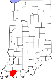
| City | Map of Indiana highlighting Warrick County | |
| Towns | ||
| Townships | ||
| Unincorporated communities |
| |