National Register of Historic Places listings in Washington County, Indiana
This is a list of the National Register of Historic Places listings in Washington County, Indiana.
This is intended to be a complete list of the properties and districts on the National Register of Historic Places in Washington County, Indiana, United States. Latitude and longitude coordinates are provided for many National Register properties and districts; these locations may be seen together in an online map.[1]
There are 9 properties and districts listed on the National Register in the county.
Properties and districts located in incorporated areas display the name of the municipality, while properties and districts in unincorporated areas display the name of their civil township. Properties and districts split between multiple jurisdictions display the names of all jurisdictions.
- This National Park Service list is complete through NPS recent listings posted June 19, 2020.[2]
Current listings
| [3] | Name on the Register[4] | Image | Date listed[5] | Location | City or town | Description |
|---|---|---|---|---|---|---|
| 1 | Beck's Mill |  Beck's Mill |
December 7, 1990 (#90001789) |
Beck's Mill Rd. at Mill Creek, southwest of Salem 38°32′17″N 86°09′18″W |
Howard Township | |
| 2 | Beck's Mill Bridge |  Beck's Mill Bridge |
September 20, 2007 (#07000981) |
Carries Beck's Mill Road over Mill Creek, southwest of Salem 38°32′14″N 86°09′16″W |
Howard Township | |
| 3 | Campbell-Gill House | August 29, 2019 (#100004365) |
8178 S. IN 335 38°29′12″N 86°01′07″W |
New Pekin | ||
| 4 | Cavanaugh Bridge |  Cavanaugh Bridge |
December 19, 2007 (#07001280) |
0.6 miles south of County Road 700S on County Road 550W over the Muscatatuck River, southwest of Brownstown 38°45′48″N 86°08′12″W |
Jefferson Township | Extends into Jackson County |
| 5 | First Baptist Church | 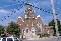 First Baptist Church |
March 21, 1985 (#85000602) |
201 N. High St. 38°36′25″N 86°05′58″W |
Salem | |
| 6 | Hay-Morrison House |  Hay-Morrison House |
October 26, 1971 (#71000007) |
106 S. College Ave. 38°36′19″N 86°05′50″W |
Salem | |
| 7 | Salem Downtown Historic District |  Salem Downtown Historic District |
October 10, 1997 (#97001181) |
Roughly bounded by Mulberry, Hackberry, and Hayes Sts., the CSX railroad tracks, and Brock Creek 38°36′20″N 86°06′00″W |
Salem | |
| 8 | Washington County Courthouse | 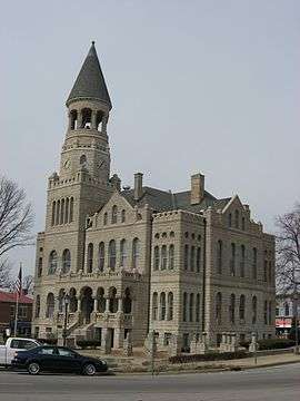 Washington County Courthouse |
June 16, 1980 (#80000047) |
Public Sq. 38°36′20″N 86°06′03″W |
Salem | |
| 9 | Washington County Jail and Sheriff's Residence |  Washington County Jail and Sheriff's Residence |
November 23, 1984 (#84000280) |
106 S. Main St. 38°36′17″N 86°06′02″W |
Salem |
See also
| Wikimedia Commons has media related to National Register of Historic Places in Washington County, Indiana. |
References
- The latitude and longitude information provided in this table was derived originally from the National Register Information System, which has been found to be fairly accurate for about 99% of listings. Some locations in this table may have been corrected to current GPS standards.
- "National Register of Historic Places: Weekly List Actions". National Park Service, United States Department of the Interior. Retrieved on June 19, 2020.
- Numbers represent an ordering by significant words. Various colorings, defined here, differentiate National Historic Landmarks and historic districts from other NRHP buildings, structures, sites or objects.
- "National Register Information System". National Register of Historic Places. National Park Service. March 13, 2009.
- The eight-digit number below each date is the number assigned to each location in the National Register Information System database, which can be viewed by clicking the number.
| Topics | |
|---|---|
| Lists by state |
|
| Lists by insular areas | |
| Lists by associated state | |
| Other areas | |
| Related | |
| |

Municipalities and communities of Washington County, Indiana, United States | ||
|---|---|---|
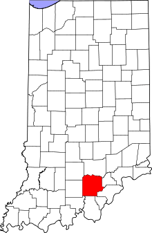
| City | Map of Indiana highlighting Washington County | |
| Towns | ||
| Townships | ||
| CDP | ||
| Unincorporated communities |
| |