National Register of Historic Places listings in Henry County, Indiana
This is a list of the National Register of Historic Places listings in Henry County, Indiana.

This is intended to be a complete list of the properties and districts on the National Register of Historic Places in Henry County, Indiana, United States. Latitude and longitude coordinates are provided for many National Register properties and districts; these locations may be seen together in a map.[1]
There are 14 properties and districts listed on the National Register in the county.
Properties and districts located in incorporated areas display the name of the municipality, while properties and districts in unincorporated areas display the name of their civil township. Properties and districts split between multiple jurisdictions display the names of all jurisdictions.
- This National Park Service list is complete through NPS recent listings posted June 19, 2020.[2]
Current listings
| [3] | Name on the Register[4] | Image | Date listed[5] | Location | City or town | Description |
|---|---|---|---|---|---|---|
| 1 | Chrysler Enclosure | 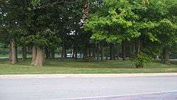 Chrysler Enclosure |
September 23, 1999 (#99001156) |
Western side of Ross St. at Chrysler High School[6] 39°54′41″N 85°22′32″W |
New Castle | |
| 2 | Gen. William Grose House | 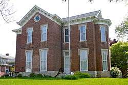 Gen. William Grose House |
June 23, 1983 (#83000034) |
614 S. 14th St. 39°55′33″N 85°22′09″W |
New Castle | |
| 3 | Guyer Opera House | 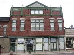 Guyer Opera House |
December 6, 1979 (#79000018) |
U.S. Route 40 39°48′25″N 85°21′12″W |
Lewisville | |
| 4 | John W. Hedrick House |  John W. Hedrick House |
December 27, 1984 (#84000491) |
506 High St. 40°03′22″N 85°32′01″W |
Middletown | |
| 5 | Henry County Courthouse | 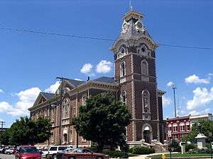 Henry County Courthouse |
April 2, 1981 (#81000013) |
Courthouse Sq. 39°55′51″N 85°22′16″W |
New Castle | |
| 6 | Elias Hinshaw House |  Elias Hinshaw House |
May 3, 1984 (#84001045) |
16 W. Main St. 39°47′43″N 85°31′42″W |
Knightstown | |
| 7 | Knightstown Academy | 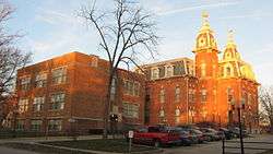 Knightstown Academy |
September 29, 1976 (#76000022) |
Cary St. 39°48′00″N 85°31′29″W |
Knightstown | |
| 8 | Knightstown Historic District | 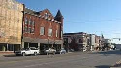 Knightstown Historic District |
May 22, 1986 (#86001104) |
Roughly bounded by Morgan, Adams, 3rd, and McCullum Sts. 39°47′46″N 85°31′38″W |
Knightstown | |
| 9 | Middletown Commercial Historic District | 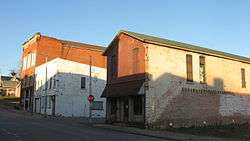 Middletown Commercial Historic District |
March 31, 2010 (#10000122) |
Intersection of 5th and Locust Sts., stretching approximately 125 feet north and 180 feet south of Locust and one block west 40°03′15″N 85°32′00″W |
Middletown | |
| 10 | New Castle Archeological Site | 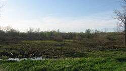 New Castle Archeological Site |
April 26, 1976 (#76000023) |
Grounds of the former New Castle State Hospital, southeast of the confluence of the Big and Little Blue Rivers, and northeast of New Castle[7] 39°57′20″N 85°21′06″W |
Henry Township | |
| 11 | New Castle Commercial Historic District |  New Castle Commercial Historic District |
December 19, 1991 (#91001868) |
Roughly bounded by Fleming and 11th Sts., Central Ave. and the Norfolk Southern railroad tracks 39°55′53″N 85°22′12″W |
New Castle | |
| 12 | Old Knightstown and Glen Cove Cemeteries | June 4, 2019 (#100004046) |
8875 S. State Rd. 109 39°48′14″N 85°31′56″W |
Knightstown | ||
| 13 | Richsquare Friends Meetinghouse and Cemetery | 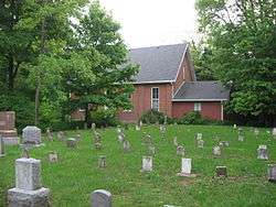 Richsquare Friends Meetinghouse and Cemetery |
April 19, 2006 (#06000305) |
5685 S. 250E, north of Lewisville 39°51′10″N 85°20′29″W |
Franklin Township | |
| 14 | Henry F. Whitelock House and Farm | 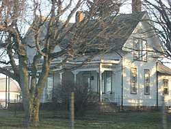 Henry F. Whitelock House and Farm |
December 22, 1983 (#83003565) |
State Road 38, north of Shirley 39°57′46″N 85°32′37″W |
Harrison Township |
See also
| Wikimedia Commons has media related to National Register of Historic Places in Henry County, Indiana. |
References
- The latitude and longitude information provided in this table was derived originally from the National Register Information System, which has been found to be fairly accurate for about 99% of listings. Some locations in this table may have been corrected to current GPS standards.
- "National Register of Historic Places: Weekly List Actions". National Park Service, United States Department of the Interior. Retrieved on June 19, 2020.
- Numbers represent an ordering by significant words. Various colorings, defined here, differentiate National Historic Landmarks and historic districts from other NRHP buildings, structures, sites or objects.
- "National Register Information System". National Register of Historic Places. National Park Service. March 13, 2009.
- The eight-digit number below each date is the number assigned to each location in the National Register Information System database, which can be viewed by clicking the number.
- Location derived from McCord, Beth. An Archaeological Assessment of Three Unique Woodland Sites in Henry County, Indiana. Muncie: Ball State U, 1998, 52. The NRIS lists the site as "Address Restricted".
- Location derived from Swartz, B.K., Jr. The New Castle Site: A Hopewell Ceremonial Complex in East Central Indiana. Muncie: Ball State U, 1976, 3. The NRIS lists the site as "Address Restricted".
| Topics | |
|---|---|
| Lists by state |
|
| Lists by insular areas | |
| Lists by associated state | |
| Other areas | |
| Related | |
| |

Municipalities and communities of Henry County, Indiana, United States | ||
|---|---|---|
| City | Map of Indiana highlighting Henry County | |
| Towns | ||
| Townships | ||
| Unincorporated communities | ||
| Footnotes | ‡This populated place also has portions in an adjacent county or counties | |