National Register of Historic Places listings in Vermillion County, Indiana
This is a list of the National Register of Historic Places listings in Vermillion County, Indiana.
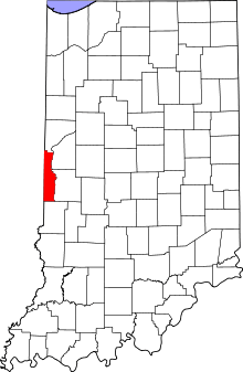
This is intended to be a complete list of the properties and districts on the National Register of Historic Places in Vermillion County, Indiana, United States. Latitude and longitude coordinates are provided for many National Register properties and districts; these locations may be seen together in a map.[1]
There are 8 properties and districts listed on the National Register in the county. Another property was once listed but has been removed.
Properties and districts located in incorporated areas display the name of the municipality, while properties and districts in unincorporated areas display the name of their civil township. Properties and districts split between multiple jurisdictions display the names of all jurisdictions.
- This National Park Service list is complete through NPS recent listings posted June 19, 2020.[2]
Current listings
| [3] | Name on the Register[4] | Image | Date listed[5] | Location | City or town | Description |
|---|---|---|---|---|---|---|
| 1 | Clinton Downtown Historic District | 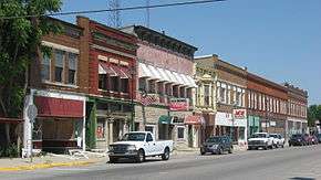 Clinton Downtown Historic District |
March 15, 2000 (#00000205) |
Roughly between S. Water and S. 3rd Sts., and Elm St. to the CSX railroad right-of-way 39°39′34″N 87°23′54″W |
Clinton | |
| 2 | Eugene Covered Bridge | 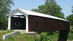 Eugene Covered Bridge |
June 10, 1994 (#94000585) |
Former County Road 00 over the Big Vermillion River at Eugene 39°58′09″N 87°28′23″W |
Eugene Township | |
| 3 | Hill Crest Community Center | 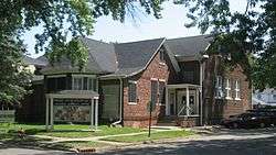 Hill Crest Community Center |
December 15, 1997 (#97001555) |
505 N. 8th St. 39°40′25″N 87°24′25″W |
Clinton | |
| 4 | Newport Covered Bridge | 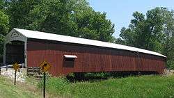 Newport Covered Bridge |
June 10, 1994 (#94000589) |
County Road 50N over the Little Vermillion River, northwest of Newport 39°53′29″N 87°26′00″W |
Vermillion Township | |
| 5 | Possum Bottom Covered Bridge |  Possum Bottom Covered Bridge |
June 10, 1994 (#94000584) |
Northern side of U.S. Route 36, 0.2 miles east of its junction with East Rd. and southeast of Dana 39°47′50″N 87°27′12″W |
Helt Township | |
| 6 | Salem Methodist Episcopal Church |  Salem Methodist Episcopal Church |
February 22, 1979 (#79000022) |
North of Clinton on State Road 63 39°43′55″N 87°23′58″W |
Helt Township | |
| 7 | Vermillion County Courthouse |  Vermillion County Courthouse |
December 19, 2007 (#07001283) |
255 S. Main St. 39°53′05″N 87°24′34″W |
Newport | |
| 8 | Vermillion County Jail and Sheriff's Residence |  Vermillion County Jail and Sheriff's Residence |
March 12, 1999 (#99000305) |
220 E. Market St. 39°51′27″N 87°24′22″W |
Newport |
Former listing
| [3] | Name on the Register | Image | Date listed | Date removed | Location | City or town | Summary |
|---|---|---|---|---|---|---|---|
| 1 | Brouilletts Creek Covered Bridge | June 10, 1994 (#94000586) | June 2, 1999 | County Roads 100W and 1700S over Brouilletts Creek |
Clinton | Disassembled in 1994 and currently in storage in its entirety for reassembly in the future.[6] |
See also
| Wikimedia Commons has media related to National Register of Historic Places in Vermillion County, Indiana. |
References
- The latitude and longitude information provided in this table was derived originally from the National Register Information System, which has been found to be fairly accurate for about 99% of listings. Some locations in this table may have been corrected to current GPS standards.
- "National Register of Historic Places: Weekly List Actions". National Park Service, United States Department of the Interior. Retrieved on June 19, 2020.
- Numbers represent an ordering by significant words. Various colorings, defined here, differentiate National Historic Landmarks and historic districts from other NRHP buildings, structures, sites or objects.
- "National Register Information System". National Register of Historic Places. National Park Service. March 13, 2009.
- The eight-digit number below each date is the number assigned to each location in the National Register Information System database, which can be viewed by clicking the number.
- Bridgehunter.com
| Topics | |
|---|---|
| Lists by state |
|
| Lists by insular areas | |
| Lists by associated state | |
| Other areas | |
| Related | |
| |

Municipalities and communities of Vermillion County, Indiana, United States | ||
|---|---|---|
| City | Map of Indiana highlighting Vermillion County | |
| Towns | ||
| Townships | ||
| CDPs | ||
| Other unincorporated communities | ||
| Ghost towns | ||
| Footnotes | ‡This populated place also has portions in an adjacent county or counties | |