National Register of Historic Places listings in Howard County, Indiana
This is a list of the National Register of Historic Places listings in Howard County, Indiana.
This is intended to be a complete list of the properties and districts on the National Register of Historic Places in Howard County, Indiana, United States. Latitude and longitude coordinates are provided for many National Register properties and districts; these locations may be seen together in a map.[1]
There are 14 properties and districts listed on the National Register in the county. Another property was once listed but has been removed.
Properties and districts located in incorporated areas display the name of the municipality, while properties and districts in unincorporated areas display the name of their civil township. Properties and districts split between multiple jurisdictions display the names of all jurisdictions.
- This National Park Service list is complete through NPS recent listings posted June 19, 2020.[2]
Current listings
| [3] | Name on the Register[4] | Image | Date listed[5] | Location | City or town | Description |
|---|---|---|---|---|---|---|
| 1 | Greentown Commercial Historic District | 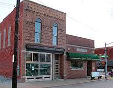 Greentown Commercial Historic District |
September 4, 2018 (#100002862) |
½ block on either side of Meridian St. between Walnut and Grant 40°28′40″N 85°58′00″W |
Greentown | |
| 2 | Elwood Haynes House | 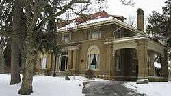 Elwood Haynes House |
September 20, 1984 (#84001054) |
1915 S. Webster St. 40°27′47″N 86°08′13″W |
Kokomo | |
| 3 | Howard Masonic Temple | December 3, 2018 (#100003182) |
316 N. Washington St. 40°29′21″N 86°08′02″W |
Kokomo | ||
| 4 | Hy-Red Gasoline Station | 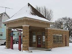 Hy-Red Gasoline Station |
September 1, 1983 (#83000035) |
203 E. Main St. 40°28′40″N 85°57′53″W |
Greentown | |
| 5 | Kokomo City Building | 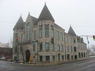 Kokomo City Building |
June 4, 1981 (#81000014) |
221 W. Walnut St. 40°29′13″N 86°08′00″W |
Kokomo | |
| 6 | Kokomo Country Club Golf Course |  Kokomo Country Club Golf Course |
September 20, 2006 (#06000854) |
1801 Country Club Dr. 40°27′43″N 86°08′36″W |
Kokomo | |
| 7 | Kokomo Courthouse Square Historic District | 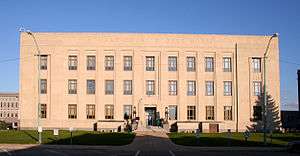 Kokomo Courthouse Square Historic District |
December 22, 2008 (#08001209) |
Bounded by Taylor St. on the north, Market St. on the east, Superior St. on the south, and Washington St. on the west 40°29′13″N 86°07′55″W |
Kokomo | |
| 8 | Kokomo High School and Memorial Gymnasium |  Kokomo High School and Memorial Gymnasium |
June 17, 2005 (#05000607) |
303 E. Superior St. and 400 Apperson Way, N. 40°29′06″N 86°07′39″W |
Kokomo | |
| 9 | Lake Erie and Western Depot Historic District |  Lake Erie and Western Depot Historic District |
September 17, 2008 (#08000917) |
Generally bounded by W. Jefferson St. on the north, N. Main St. on the east, W. Jackson St. on the south, and N. Washington St. on the west 40°29′24″N 86°07′57″W |
Kokomo | |
| 10 | Learner Building | 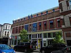 Learner Building |
September 20, 1984 (#84001055) |
107-111 E. Sycamore St. 40°29′10″N 86°07′50″W |
Kokomo | |
| 11 | Old Silk Stocking Historic District |  Old Silk Stocking Historic District |
December 22, 2008 (#08001210) |
Bounded by W. Jackson St. on the north, Washington St. on the east, Wildcat Creek on the south, and Phillips St. on the west 40°29′20″N 86°08′32″W |
Kokomo | |
| 12 | Seiberling Mansion | 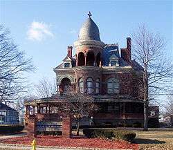 Seiberling Mansion |
December 16, 1971 (#71000006) |
1200 W. Sycamore St. 40°29′13″N 86°08′39″W |
Kokomo | |
| 13 | Henry W. Smith House |  Henry W. Smith House |
March 9, 1979 (#79000019) |
5 miles (8 km) west of Kokomo 40°28′41″N 86°13′41″W |
Clay Township | |
| 14 | George and Helen Tate House |  George and Helen Tate House |
March 6, 2018 (#100002182) |
114 E. Jefferson St. 40°29′28″N 86°07′50″W |
Kokomo |
Former listing
| [3] | Name on the Register | Image | Date listed | Date removed | Location | City or town | Summary |
|---|---|---|---|---|---|---|---|
| 1 | Frederick Youngman House | 1979 (#79000020) | March 23, 1994 | 450 S200E 40°24′46″N 86°05′20″W |
Kokomo |
See also
| Wikimedia Commons has media related to National Register of Historic Places in Howard County, Indiana. |
References
- The latitude and longitude information provided in this table was derived originally from the National Register Information System, which has been found to be fairly accurate for about 99% of listings. Some locations in this table may have been corrected to current GPS standards.
- "National Register of Historic Places: Weekly List Actions". National Park Service, United States Department of the Interior. Retrieved on June 19, 2020.
- Numbers represent an ordering by significant words. Various colorings, defined here, differentiate National Historic Landmarks and historic districts from other NRHP buildings, structures, sites or objects.
- "National Register Information System". National Register of Historic Places. National Park Service. March 13, 2009.
- The eight-digit number below each date is the number assigned to each location in the National Register Information System database, which can be viewed by clicking the number.
| Topics | |
|---|---|
| Lists by state |
|
| Lists by insular areas | |
| Lists by associated state | |
| Other areas | |
| Related | |
| |

Municipalities and communities of Howard County, Indiana, United States | ||
|---|---|---|
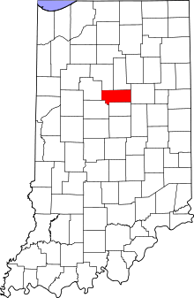
| City | Map of Indiana highlighting Howard County | |
| Towns | ||
| Townships | ||
| Other unincorporated communities | ||