National Register of Historic Places listings in Boone County, Indiana
This is a list of the National Register of Historic Places listings in Boone County, Indiana.
This is intended to be a complete list of the properties and districts on the National Register of Historic Places in Boone County, Indiana, United States. Latitude and longitude coordinates are provided for many National Register properties and districts; these locations may be seen together in a map.[1]
There are 15 properties and districts listed on the National Register in the county.
Properties and districts located in incorporated areas display the name of the municipality, while properties and districts in unincorporated areas display the name of their civil township. Properties and districts split between multiple jurisdictions display the names of all jurisdictions.
- This National Park Service list is complete through NPS recent listings posted June 19, 2020.[2]
Current listings
| [3] | Name on the Register[4] | Image | Date listed[5] | Location | City or town | Description |
|---|---|---|---|---|---|---|
| 1 | Boone County Courthouse | 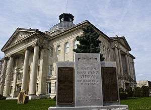 Boone County Courthouse |
September 22, 1986 (#86002703) |
Courthouse Sq. 40°02′52″N 86°28′07″W |
Lebanon | |
| 2 | Pryor Brock Farmstead |  Pryor Brock Farmstead |
June 27, 2008 (#08000569) |
8602 County Road 500S, west of Zionsville 39°58′05″N 86°18′21″W |
Eagle Township | Carpenter's rendering of Italianate architecture, symbolic of the "golden age" of Hoosier agriculture |
| 3 | Strange Nathanial Cragun House |  Strange Nathanial Cragun House |
December 15, 2011 (#11000908) |
404 W. Main St. 40°02′52″N 86°28′18″W |
Lebanon | |
| 4 | Howard School | 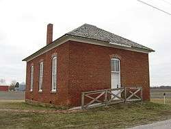 Howard School |
September 24, 2009 (#09000754) |
4555 E. County Road 750S, north of Brownsburg 39°55′51″N 86°22′56″W |
Perry Township | |
| 5 | Lebanon Courthouse Square Historic District |  Lebanon Courthouse Square Historic District |
September 12, 2016 (#16000610) |
Roughly bounded by North, East, South, Superior, and West Sts. 40°02′54″N 86°28′07″W |
Lebanon | |
| 6 | Maplelawn Farmstead |  Maplelawn Farmstead |
September 15, 2011 (#11000656) |
9575 Whitestown Rd., near Zionsville 39°57′53″N 86°17′15″W |
Eagle Township | |
| 7 | Oak Hill Cemetery | 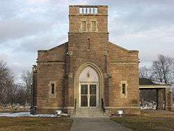 Oak Hill Cemetery |
March 26, 2014 (#14000068) |
935 E. Washington St. 40°02′50″N 86°27′16″W |
Lebanon | |
| 8 | Scotland Bridge | 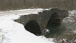 Scotland Bridge |
March 17, 1994 (#94000228) |
Lost Rd. (County Road 200E) over Sugar Creek, east of Mechanicsburg 40°10′36″N 86°25′54″W |
Clinton Township | Extends into Clinton County |
| 9 | Simpson-Breedlove House |  Simpson-Breedlove House |
March 15, 2016 (#16000075) |
3650 U.S. Route 421 39°59′24″N 86°15′40″W |
Union Township | |
| 10 | Thorntown Public Library |  Thorntown Public Library |
September 22, 1986 (#86002708) |
124 N. Market St. 40°07′50″N 86°36′22″W |
Thorntown | |
| 11 | Traders Point Eagle Creek Rural Historic District | 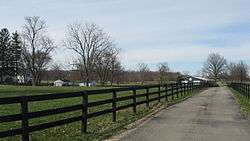 Traders Point Eagle Creek Rural Historic District |
June 17, 2009 (#09000433) |
Roughly between Interstate 865, Interstate 465, and Lafayette Rd. 39°55′32″N 86°17′47″W |
Eagle Township | Extends into Pike Township in Marion County[6] |
| 12 | Traders Point Hunt Rural Historic District | 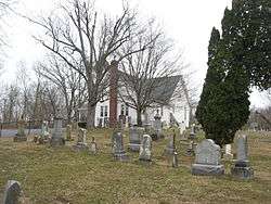 Traders Point Hunt Rural Historic District |
June 17, 2009 (#09000421) |
Roughly bounded by State Road 334, Interstate 865, Old Hunt Club Rd., and County Road 850E, southwest of Zionsville 39°56′25″N 86°19′17″W |
Eagle Township | Eagle Township and Pike Township, Indiana MPS. |
| 13 | Town Hall (Castle Hall) | 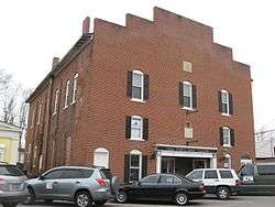 Town Hall (Castle Hall) |
June 9, 1983 (#83000115) |
65 E. Cedar St. 39°57′05″N 86°15′40″W |
Zionsville | |
| 14 | Ulen Historic District | 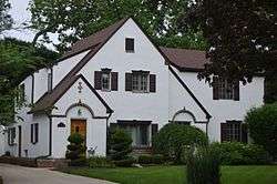 Ulen Historic District |
September 16, 2015 (#15000591) |
Roughly Ulen Country Club and Golf Course, and houses along Ulen Boulevard and East Dr. 40°03′48″N 86°27′49″W |
Ulen | |
| 15 | Andrew B. VanHuys Round Barn | 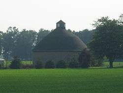 Andrew B. VanHuys Round Barn |
April 2, 1993 (#93000181) |
755 W. County Road 125 S., south of Lebanon[7] 40°01′17″N 86°29′00″W |
Center Township |
See also
| Wikimedia Commons has media related to National Register of Historic Places in Boone County, Indiana. |
References
- The latitude and longitude information provided in this table was derived originally from the National Register Information System, which has been found to be fairly accurate for about 99% of listings. Some locations in this table may have been corrected to current GPS standards.
- "National Register of Historic Places: Weekly List Actions". National Park Service, United States Department of the Interior. Retrieved on June 19, 2020.
- Numbers represent an ordering by significant words. Various colorings, defined here, differentiate National Historic Landmarks and historic districts from other NRHP buildings, structures, sites or objects.
- "National Register Information System". National Register of Historic Places. National Park Service. March 13, 2009.
- The eight-digit number below each date is the number assigned to each location in the National Register Information System database, which can be viewed by clicking the number.
- Fife, Camille B. National Register of Historic Places Inventory/Nomination: Traders Point Eagle Creek Rural Historic District. National Park Service, 2008-05, 90.
- Location derived from Indiana Division of Historic Preservation and Archaeology, Historic Indiana: Indiana Properties Listed in the National Register of Historic Places 2003 - 2004 Archived 2011-06-14 at the Wayback Machine, n.d., 17. Accessed 2010-11-16. The NRIS lists the site as "Address Restricted".
| Topics | |
|---|---|
| Lists by state |
|
| Lists by insular areas | |
| Lists by associated state | |
| Other areas | |
| Related | |
| |

Municipalities and communities of Boone County, Indiana, United States | ||
|---|---|---|
| City | Map of Indiana highlighting Boone County | |
| Towns | ||
| Townships | ||
| Unincorporated communities | ||
| Footnotes | ‡This populated place also has portions in an adjacent county or counties | |