National Register of Historic Places listings in Lawrence County, Indiana
This is a list of the National Register of Historic Places listings in Lawrence County, Indiana.

This is intended to be a complete list of the properties and districts on the National Register of Historic Places in Lawrence County, Indiana, United States. Latitude and longitude coordinates are provided for many National Register properties and districts; these locations may be seen together in a map.[1]
There are 13 properties and districts listed on the National Register in the county.
Properties and districts located in incorporated areas display the name of the municipality, while properties and districts in unincorporated areas display the name of their civil township. Properties and districts split between multiple jurisdictions display the names of all jurisdictions.
- This National Park Service list is complete through NPS recent listings posted June 19, 2020.[2]
Current listings
| [3] | Name on the Register[4] | Image | Date listed[5] | Location | City or town | Description |
|---|---|---|---|---|---|---|
| 1 | Bedford Courthouse Square Historic District | 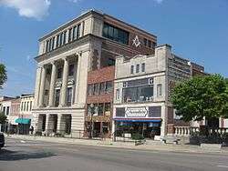 Bedford Courthouse Square Historic District |
June 8, 1995 (#95000704) |
Roughly bounded by L, 14th, 17th and H Sts. 38°51′42″N 86°29′01″W |
Bedford | |
| 2 | Bono Archaeological Site (12 Lr 194) |  Bono Archaeological Site (12 Lr 194) |
May 30, 1985 (#85001166) |
On a bluff above the White River, ½ mile west of the riverbank and 1 mile north of Bono[6] 38°44′41″N 86°19′42″W |
Bono Township | |
| 3 | Clampitt Site |  Clampitt Site |
March 15, 2016 (#16000076) |
Address Restricted |
Guthrie Township | |
| 4 | Helton-Mayo Farm | 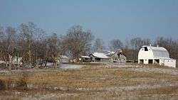 Helton-Mayo Farm |
June 9, 1995 (#95000709) |
Junction of Boyd Ln. and State Road 58, northeast of Bedford 38°53′11″N 86°27′05″W |
Shawswick Township | |
| 5 | Indiana Limestone Company Building | 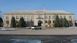 Indiana Limestone Company Building |
December 21, 1993 (#93001412) |
405 I St. 38°52′31″N 86°29′00″W |
Bedford | |
| 6 | Madden School |  Madden School |
June 15, 2000 (#00000673) |
620 H St. 38°52′21″N 86°28′53″W |
Bedford | |
| 7 | Mitchell Downtown Historic District | Mitchell Downtown Historic District |
September 26, 1997 (#97001175) |
Roughly bounded by 10th, Oak, 5th, and N. Mississippi Sts. 38°44′00″N 86°28′28″W |
Mitchell | |
| 8 | Mitchell Opera House | 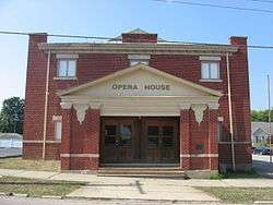 Mitchell Opera House |
April 2, 1981 (#81000020) |
7th and Brooks Sts. 38°44′04″N 86°28′27″W |
Mitchell | |
| 9 | C.S. Norton Mansion | 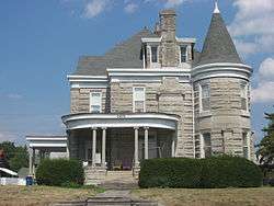 C.S. Norton Mansion |
June 22, 1976 (#76000026) |
1415 15th St. 38°51′45″N 86°29′28″W |
Bedford | |
| 10 | Otis Park and Golf Course |  Otis Park and Golf Course |
December 20, 2002 (#02001560) |
Tunnelton Rd. 38°51′31″N 86°27′17″W |
Bedford | |
| 11 | William A. Ragsdale House |  William A. Ragsdale House |
December 20, 2002 (#02001565) |
607 Tunnelton Rd. 38°51′32″N 86°27′36″W |
Bedford | |
| 12 | Williams Bridge | Indiana.JPG) Williams Bridge |
November 9, 1981 (#81000018) |
Southwest of Williams on County Road 11 38°47′48″N 86°39′54″W |
Spice Valley Township | |
| 13 | Zahn Historic District | 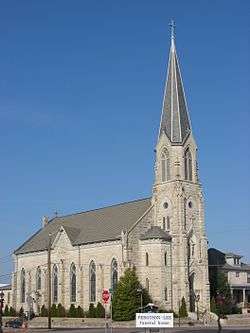 Zahn Historic District |
August 28, 1998 (#98001100) |
Roughly bounded by 17th, 20th, J., and H Sts. 38°51′29″N 86°28′57″W |
Bedford |
See also
| Wikimedia Commons has media related to National Register of Historic Places in Lawrence County, Indiana. |
References
- The latitude and longitude information provided in this table was derived originally from the National Register Information System, which has been found to be fairly accurate for about 99% of listings. Some locations in this table may have been corrected to current GPS standards.
- "National Register of Historic Places: Weekly List Actions". National Park Service, United States Department of the Interior. Retrieved on June 19, 2020.
- Numbers represent an ordering by significant words. Various colorings, defined here, differentiate National Historic Landmarks and historic districts from other NRHP buildings, structures, sites or objects.
- "National Register Information System". National Register of Historic Places. National Park Service. March 13, 2009.
- The eight-digit number below each date is the number assigned to each location in the National Register Information System database, which can be viewed by clicking the number.
- Location derived from Guernsey, E.Y. "Archaeological Survey of Lawrence County". Extra number of Indiana History Bulletin 1 (July 1924): 8 and 22. The NRIS lists the site as "Address Restricted".
| Topics | |
|---|---|
| Lists by state |
|
| Lists by insular areas | |
| Lists by associated state | |
| Other areas | |
| Related | |
| |

Municipalities and communities of Lawrence County, Indiana, United States | ||
|---|---|---|
| Cities | Map of Indiana highlighting Lawrence County | |
| Town | ||
| Townships | ||
| CDPs | ||
| Unincorporated communities |
| |
| Former communities | ||