National Register of Historic Places listings in Clark County, Indiana
This is a list of the National Register of Historic Places listings in Clark County, Indiana.
This is intended to be a complete list of the properties and districts on the National Register of Historic Places in Clark County, Indiana, United States. Latitude and longitude coordinates are provided for many National Register properties and districts; these locations may be seen together in an online map.[1]
There are 20 properties and districts listed on the National Register in the county. Another property was once listed but has been removed.
Properties and districts located in incorporated areas display the name of the municipality, while properties and districts in unincorporated areas display the name of their civil township. Properties and districts split between multiple jurisdictions display the names of all jurisdictions.
- This National Park Service list is complete through NPS recent listings posted June 19, 2020.[2]
Current listings
| [3] | Name on the Register[4] | Image | Date listed[5] | Location | City or town | Description |
|---|---|---|---|---|---|---|
| 1 | Abbott-Holloway Farm | 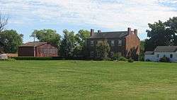 Abbott-Holloway Farm |
September 8, 1994 (#94001129) |
Roughly bounded by 2nd and Walnut Sts. and the Ohio River at Bethlehem 38°32′16″N 85°25′15″W |
Bethlehem Township | |
| 2 | Bottorff-McCulloch Farm | 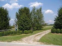 Bottorff-McCulloch Farm |
June 9, 1995 (#95000699) |
6702 Bethany Rd., southwest of Charlestown 38°24′53″N 85°41′14″W |
Charlestown Township | |
| 3 | Thomas Downs House | 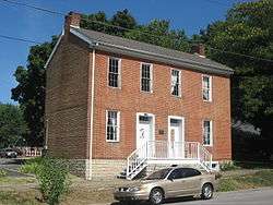 Thomas Downs House |
December 6, 1984 (#84000490) |
1045 Main St. 38°26′40″N 85°39′35″W |
Charlestown | |
| 4 | Benjamin Ferguson House | 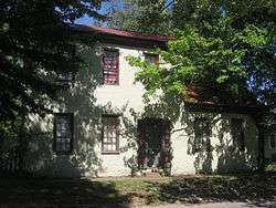 Benjamin Ferguson House |
June 16, 1983 (#83000118) |
673 High St. 38°26′28″N 85°39′46″W |
Charlestown | |
| 5 | Henry French House | 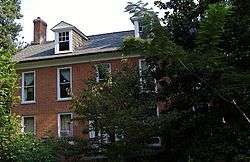 Henry French House |
June 29, 1989 (#89000772) |
217 E. High St. 38°16′49″N 85°43′16″W |
Jeffersonville | |
| 6 | Grisamore House | 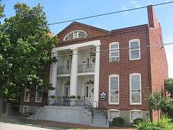 Grisamore House |
May 9, 1983 (#83000119) |
111-113 W. Chestnut St. 38°16′17″N 85°44′27″W |
Jeffersonville | |
| 7 | Howard Home |  Howard Home |
July 5, 1973 (#73000031) |
1101 E. Market St. 38°16′42″N 85°43′31″W |
Jeffersonville | |
| 8 | Mitchell P. Howes' Lime Kiln and Quarry | 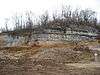 Mitchell P. Howes' Lime Kiln and Quarry |
December 30, 2013 (#13001007) |
Upper River Rd.[6] 38°20′30″N 85°38′54″W |
Utica Township | |
| 9 | Indiana State Prison South-Indiana Reformatory- Colgate-Palmolive Historic District | March 13, 2019 (#100003501) |
1410 S. Clark Blvd. 38°16′28″N 85°45′10″W |
Clarksville | ||
| 10 | Lincoln Heights Historic District | March 6, 2020 (#100005043) |
Bounded by Lewis & Clark Pkwy., Hibiscus Dr., the south side of Lynnwood Dr., and Lincoln Dr. 38°18′15″N 85°46′35″W |
Clarksville | ||
| 11 | Louisville Municipal Bridge, Pylons and Administration Building | 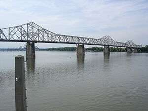 Louisville Municipal Bridge, Pylons and Administration Building |
March 8, 1984 (#84001578) |
Spans the Ohio River between Louisville, Kentucky and Jeffersonville 38°15′52″N 85°45′06″W |
Jeffersonville | Extends into Jefferson County, Kentucky |
| 12 | Old Clarksville Site | 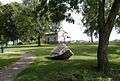 Old Clarksville Site |
December 16, 1974 (#74000028) |
Off Harrison Ave. at the Ohio River[7] 38°17′13″N 85°46′34″W |
Clarksville | |
| 13 | Old Jeffersonville Historic District | 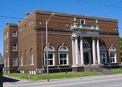 Old Jeffersonville Historic District |
October 6, 1987 (#87001461) |
Roughly bounded by Court Ave., Graham St., the Ohio River, and Interstate 65 38°16′26″N 85°44′11″W |
Jeffersonville | |
| 14 | Pleasant Ridge Historic District | December 3, 2018 (#100003178) |
Roughly between Hampton Ct., Marcy, Audubon, and Thompson Sts., Winthrop and Kenwood Aves., and Halcyon and Ridge Rds. 38°26′50″N 85°40′16″W |
Charlestown | ||
| 15 | Smith-Sutton Site | 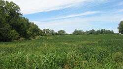 Smith-Sutton Site |
April 10, 2012 (#12000183) |
Address Restricted |
Utica Township | |
| 16 | Spring Street Freight House | 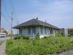 Spring Street Freight House |
March 29, 2007 (#07000209) |
1030 Spring St. 38°16′49″N 85°44′48″W |
Jeffersonville | Former depot of the Big Four Railroad |
| 17 | Samuel Starkweather's Lime Kiln and Quarry | 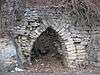 Samuel Starkweather's Lime Kiln and Quarry |
December 30, 2013 (#13001008) |
Upper River Rd.[6] 38°20′46″N 85°38′43″W |
Utica Township | |
| 18 | Moses H. Tyler Company Lime Kiln and Quarry No. 1 | 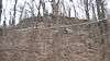 Moses H. Tyler Company Lime Kiln and Quarry No. 1 |
December 30, 2013 (#13001009) |
Upper River Rd.[6] 38°20′32″N 85°38′53″W |
Utica Township | |
| 19 | Watson House | 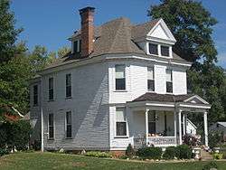 Watson House |
September 1, 1983 (#83000051) |
1015 Water St. 38°26′43″N 85°39′39″W |
Charlestown | |
| 20 | John Work House and Mill Site |  John Work House and Mill Site |
January 3, 2001 (#00001546) |
Northern side of Tunnel Mill Rd., west of Fourteen Mile Creek and northeast of Charlestown[8] 38°28′54″N 85°37′34″W |
Charlestown Township | Site of Tunnel Mill Scout Reservation[4] |
Former listing
| [3] | Name on the Register | Image | Date listed | Date removed | Location | City or town | Summary |
|---|---|---|---|---|---|---|---|
| 1 | Borden Institute | June 13, 1973 (#73000030) | July 16, 1986 | West St. 38°28′05″N 85°56′37″W |
Borden | Demolished. |
See also
| Wikimedia Commons has media related to National Register of Historic Places in Clark County, Indiana. |
References
- The latitude and longitude information provided in this table was derived originally from the National Register Information System, which has been found to be fairly accurate for about 99% of listings. Some locations in this table may have been corrected to current GPS standards.
- "National Register of Historic Places: Weekly List Actions". National Park Service, United States Department of the Interior. Retrieved on June 19, 2020.
- Numbers represent an ordering by significant words. Various colorings, defined here, differentiate National Historic Landmarks and historic districts from other NRHP buildings, structures, sites or objects.
- "National Register Information System". National Register of Historic Places. National Park Service. March 13, 2009.
- The eight-digit number below each date is the number assigned to each location in the National Register Information System database, which can be viewed by clicking the number.
- Federal Highway Administration, Indiana Department of Transportation, and Kentucky Transportation Cabinet. Supplemental Final Environmental Impact Statement. FHA et al via Ohio River Bridges Project, n.d., 5-69.
- Location derived from Division of Historic Preservation and Archaeology. Clark County Interim Report. Indianapolis: Indiana Department of Natural Resources, 1988-10, 32-33. The NRIS lists the site as "Address Restricted".
- Location is for the house, derived from Division of Historic Preservation and Archaeology. Clark County Interim Report. Indianapolis: Indiana Department of Natural Resources, 1988-10, 32-33. The NRIS lists the site as "Address Restricted".
| Topics | |
|---|---|
| Lists by state |
|
| Lists by insular areas | |
| Lists by associated state | |
| Other areas | |
| Related | |
| |

Municipalities and communities of Clark County, Indiana, United States | ||
|---|---|---|
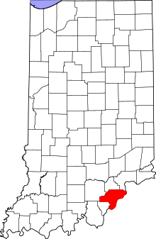
| Cities | Map of Indiana highlighting Clark County | |
| Towns | ||
| Townships | ||
| CDPs | ||
| Unincorporated communities |
| |
| Footnotes | ‡This populated place also has portions in an adjacent county or counties | |