National Register of Historic Places listings in Ripley County, Indiana
This is a list of the National Register of Historic Places listings in Ripley County, Indiana.
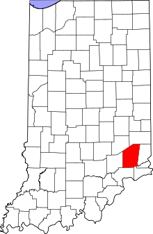
Location of Ripley County in Indiana
This is intended to be a complete list of the properties on the National Register of Historic Places in Ripley County, Indiana, United States. Latitude and longitude coordinates are provided for many National Register properties; these locations may be seen together in a map.[1]
There are 16 properties listed on the National Register in the county.
Properties and districts located in incorporated areas display the name of the municipality, while properties and districts in unincorporated areas display the name of their civil township. Properties and districts split between multiple jurisdictions display the names of all jurisdictions.
- This National Park Service list is complete through NPS recent listings posted June 19, 2020.[2]
Current listings
| [3] | Name on the Register[4] | Image | Date listed[5] | Location | City or town | Description |
|---|---|---|---|---|---|---|
| 1 | Busching Covered Bridge | 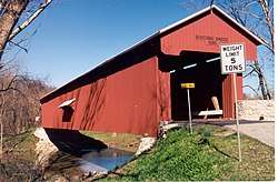 Busching Covered Bridge |
March 13, 2019 (#100003509) |
E. Perry St./E Cty. Rd. 25 S at Laughery Cr. 39°04′04″N 85°14′16″W |
Versailles vicinity | 1885 Howe truss bridge, located Versailles State Park. |
| 2 | Central Batesville Historic District | 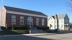 Central Batesville Historic District |
September 15, 2011 (#11000659) |
Roughly bounded by Catherine, Vine, and Boehringer Sts., and Eastern Ave. 39°17′52″N 85°13′19″W |
Batesville | |
| 3 | Central House | 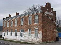 Central House |
September 23, 1982 (#82000071) |
State Road 229 39°12′18″N 85°19′42″W |
Napoleon | |
| 4 | Collin's Ford Bridge |  Collin's Ford Bridge |
July 30, 1996 (#96000787) |
Big Oaks National Wildlife Refuge, approximately 0.75 miles west of New Marion 39°00′29″N 85°22′14″W |
Shelby Township | |
| 5 | Elias Conwell House | 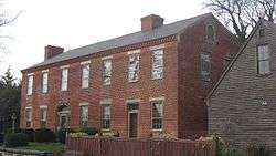 Elias Conwell House |
May 14, 1979 (#79000041) |
Wilson St. and U.S. Route 421 39°12′23″N 85°19′50″W |
Napoleon | |
| 6 | Friendship Stone Arch Bridge | March 11, 2019 (#100003510) |
Olean Rd./Cty Rd. 525 E over Raccoon Cr. 38°58′26″N 85°09′33″W |
Friendship vicinity | ||
| 7 | Marble Creek Bridge | July 30, 1996 (#96000785) |
Big Oaks National Wildlife Refuge, approximately 0.75 miles west of the junction of G and W. Recovery Rds. 38°55′39″N 85°26′31″W |
Shelby Township | ||
| 8 | Milan Masonic Lodge No. 31 | 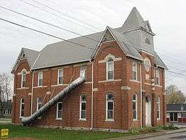 Milan Masonic Lodge No. 31 |
January 9, 2013 (#12001155) |
312 Main St. 39°07′30″N 85°07′54″W |
Milan | |
| 9 | Old Timbers | July 30, 1996 (#96000786) |
Big Oaks National Wildlife Refuge, approximately 0.5 miles southeast of the junction of K Rd. and Northeast Exit 39°00′17″N 85°23′26″W |
Shelby Township | ||
| 10 | Otter Creek Covered Bridge | March 13, 2019 (#100003511) |
N. Cty. Rd. 850 W at Otter Cr. 39°05′07″N 85°24′37″W |
Holton vicinity | ||
| 11 | John Linsey Rand House | 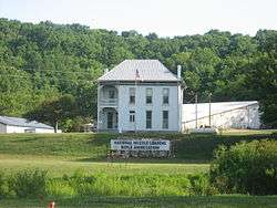 John Linsey Rand House |
June 10, 1994 (#94000582) |
Southwestern corner of the junction of State Road 62 and Maxine Moss Dr. at Friendship 38°57′57″N 85°08′43″W |
Brown Township | |
| 12 | Ripley County Courthouse | .jpg) Ripley County Courthouse |
September 24, 2009 (#09000762) |
115 N. Main St. 39°04′19″N 85°15′07″W |
Versailles | |
| 13 | Straber Ford Bridge | 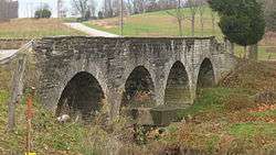 Straber Ford Bridge |
December 24, 2009 (#09001132) |
County Road 500N over Otter Creek, northwest of Osgood 39°08′53″N 85°21′44″W |
Center Township | |
| 14 | Fernando G. Taylor House | .jpg) Fernando G. Taylor House |
September 22, 1986 (#86002710) |
Northeastern corner of Main and Tyson Sts. 39°04′17″N 85°15′03″W |
Versailles | |
| 15 | Tyson United Methodist Church | .jpg) Tyson United Methodist Church |
September 8, 1994 (#94001106) |
324 W. Tyson St. 39°04′19″N 85°15′14″W |
Versailles | |
| 16 | Versailles School and Tyson Auditorium | .jpg) Versailles School and Tyson Auditorium |
April 19, 2006 (#06000309) |
100 S. High St. 39°04′18″N 85°15′20″W |
Versailles |
See also
| Wikimedia Commons has media related to National Register of Historic Places in Ripley County, Indiana. |
References
- The latitude and longitude information provided in this table was derived originally from the National Register Information System, which has been found to be fairly accurate for about 99% of listings. Some locations in this table may have been corrected to current GPS standards.
- "National Register of Historic Places: Weekly List Actions". National Park Service, United States Department of the Interior. Retrieved on June 19, 2020.
- Numbers represent an ordering by significant words. Various colorings, defined here, differentiate National Historic Landmarks and historic districts from other NRHP buildings, structures, sites or objects.
- "National Register Information System". National Register of Historic Places. National Park Service. March 13, 2009.
- The eight-digit number below each date is the number assigned to each location in the National Register Information System database, which can be viewed by clicking the number.
| Topics | |
|---|---|
| Lists by state |
|
| Lists by insular areas | |
| Lists by associated state | |
| Other areas | |
| Related | |
| |

Municipalities and communities of Ripley County, Indiana, United States | ||
|---|---|---|
| City | Map of Indiana highlighting Ripley County | |
| Towns | ||
| Townships | ||
| Unincorporated communities |
| |
| Ghost town | ||
| Footnotes | ‡This populated place also has portions in an adjacent county or counties | |
This article is issued from Wikipedia. The text is licensed under Creative Commons - Attribution - Sharealike. Additional terms may apply for the media files.