National Register of Historic Places listings in Clinton County, Indiana
This is a list of the National Register of Historic Places listings in Clinton County, Indiana.
This is intended to be a complete list of the properties and districts on the National Register of Historic Places in Clinton County, Indiana, United States. Latitude and longitude coordinates are provided for many National Register properties and districts; these locations may be seen together in a map.[1]
There are 13 properties and districts listed on the National Register in the county.
Properties and districts located in incorporated areas display the name of the municipality, while properties and districts in unincorporated areas display the name of their civil township. Properties and districts split between multiple jurisdictions display the names of all jurisdictions.
- This National Park Service list is complete through NPS recent listings posted June 19, 2020.[2]
Current listings
| [3] | Name on the Register[4] | Image | Date listed[5] | Location | City or town | Description |
|---|---|---|---|---|---|---|
| 1 | Christian Ridge Historic District |  Christian Ridge Historic District |
June 22, 2003 (#03000540) |
Roughly bounded by Prairie Creek, Young and E. Washington Sts., and Harvard Terr. 40°16′43″N 86°30′21″W |
Frankfort | |
| 2 | Clinton County Courthouse |  Clinton County Courthouse |
December 5, 1978 (#78000027) |
Public Square 40°16′52″N 86°30′40″W |
Frankfort | |
| 3 | Colfax Carnegie Library |  Colfax Carnegie Library |
March 17, 1994 (#94000230) |
207 S. Clark St. 40°11′36″N 86°39′59″W |
Colfax | |
| 4 | Charles H. and Emma Condon House |  Charles H. and Emma Condon House |
January 2, 1997 (#96001545) |
603 S. Jackson St. 40°16′33″N 86°30′36″W |
Frankfort | |
| 5 | Frankfort Commercial Historic District |  Frankfort Commercial Historic District |
August 14, 1998 (#98001055) |
Roughly bounded by Walnut, Columbia, and Morrison Sts. and Prairie Creek 40°16′54″N 86°30′42″W |
Frankfort | |
| 6 | Kirklin Public Library | 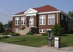 Kirklin Public Library |
March 3, 1995 (#95000206) |
115 N. Main St. 40°11′36″N 86°21′37″W |
Kirklin | |
| 7 | Old Frankfort Stone High School | 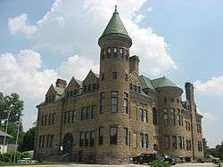 Old Frankfort Stone High School |
June 4, 1979 (#79000012) |
301 E. Clinton 40°16′48″N 86°30′32″W |
Frankfort | |
| 8 | Parkview Home of Clinton County | December 3, 2018 (#100003179) |
1501 Burlington Ave. 40°17′42″N 86°30′05″W |
Center Township | ||
| 9 | Rosenberger Building |  Rosenberger Building |
May 3, 1984 (#84001004) |
83 Old Main St. 40°11′25″N 86°39′49″W |
Colfax | |
| 10 | Scotland Bridge | 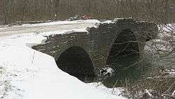 Scotland Bridge |
March 17, 1994 (#94000228) |
Lost Rd. (County Road 400E) over Sugar Creek, northeast of Mechanicsburg 40°10′36″N 86°25′54″W |
Jackson and Harrison Townships | Extends into Boone County |
| 11 | South Frankfort Historic District |  South Frankfort Historic District |
June 17, 2009 (#09000422) |
Roughly between Walnut St., Prairie Creek, and Meredith and Columbia Sts. 40°16′35″N 86°30′40″W |
Frankfort | |
| 12 | TPA Park | August 28, 2019 (#100004364) |
1 Adrian Marks Dr. 40°17′35″N 86°30′16″W |
Frankfort | ||
| 13 | John Young House |  John Young House |
November 25, 1994 (#94001348) |
9665 N. County Road 250E, northeast of Geetingsville 40°25′36″N 86°27′31″W |
Warren Township |
See also
| Wikimedia Commons has media related to National Register of Historic Places in Clinton County, Indiana. |
References
- The latitude and longitude information provided in this table was derived originally from the National Register Information System, which has been found to be fairly accurate for about 99% of listings. Some locations in this table may have been corrected to current GPS standards.
- "National Register of Historic Places: Weekly List Actions". National Park Service, United States Department of the Interior. Retrieved on June 19, 2020.
- Numbers represent an ordering by significant words. Various colorings, defined here, differentiate National Historic Landmarks and historic districts from other NRHP buildings, structures, sites or objects.
- "National Register Information System". National Register of Historic Places. National Park Service. March 13, 2009.
- The eight-digit number below each date is the number assigned to each location in the National Register Information System database, which can be viewed by clicking the number.
| Topics | |
|---|---|
| Lists by state |
|
| Lists by insular areas | |
| Lists by associated state | |
| Other areas | |
| Related | |
| |

Municipalities and communities of Clinton County, Indiana, United States | ||
|---|---|---|
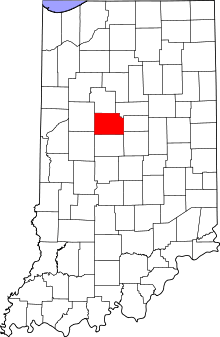
| City | Map of Indiana highlighting Clinton County | |
| Towns | ||
| Townships | ||
| Unincorporated communities |
| |